
Rare Day 3 Enhanced Risk Issued for Chicago, St. Louis, Indianapolis and Memphis as Powerful Squall Line Threatens Widespread Wind Damage and Embedded Tornadoes Sunday Night
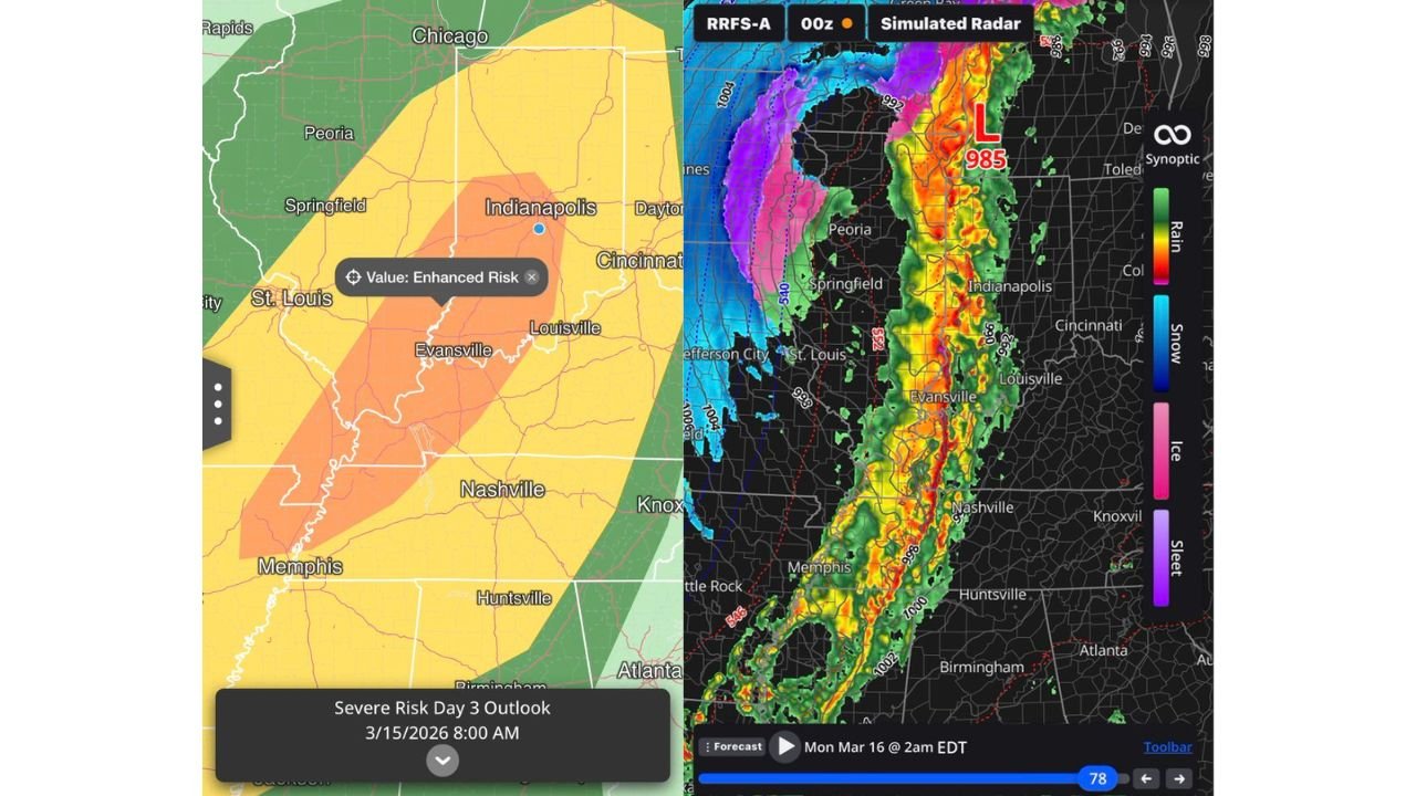
CHICAGO, ILLINOIS — A rare Day 3 Enhanced Risk has been issued for portions of the Midwest and Mid-South Sunday night, signaling growing confidence in a potentially significant severe weather outbreak stretching from northeast Arkansas through Missouri, Illinois, Indiana, Kentucky and Tennessee.
Model consistency and strengthening projections are increasingly pointing toward a high-impact squall line capable of widespread damaging winds and embedded tornadoes developing late Sunday and pushing northeast into the overnight hours.
Enhanced Risk Encompasses Major Cities
The Enhanced Risk zone now includes:
- Memphis, Tennessee
- St. Louis, Missouri
- Evansville, Indiana
- Louisville, Kentucky
- Indianapolis, Indiana
- Portions of southern and central Illinois
- Western Kentucky and western Tennessee
Chicago sits near the northern edge of the broader risk area, and while the most intense corridor appears to favor southern Illinois and Indiana, impacts could extend farther north depending on storm evolution.
Strongly Forced QLCS Likely
Forecasters highlight the potential development of a strongly forced QLCS — a quasi-linear convective system — forming during the evening hours across northeast Arkansas and southeast Missouri before surging into southern Illinois and Indiana.
This setup is concerning for several reasons:
- Rapidly increasing wind shear during peak storm development
- A powerful frontal surge moving out of the west
- 850 mb southerly winds possibly exceeding 70 knots
Even though forecast soundings show relatively modest instability, the dynamic wind environment appears more than sufficient to sustain a fast-moving line capable of producing corridors of significant wind damage.
Widespread Wind Damage Primary Concern
The leading hazard appears to be damaging straight-line winds, potentially impacting communities from Memphis and Little Rock north through St. Louis and into Indianapolis and Louisville.
Wind gusts may exceed severe criteria across a broad swath, with localized corridors of enhanced damage possible where the line bows outward.
Power outages, downed trees and travel disruptions are all possible Sunday night as the squall line advances.
Embedded Tornadoes Also Possible
Within the line, embedded tornadoes may develop — particularly in areas where small-scale circulations intensify along the leading edge.
While discrete supercells are not the primary mode expected, brief but potentially strong tornadoes cannot be ruled out, especially across:
- Northeast Arkansas
- Southeast Missouri
- Southern Illinois
- Central and southern Indiana
- Western Kentucky and Tennessee
Given the rapid forward speed of the system, warning lead times may be limited.
Simulated Radar Shows Intense Line
Model simulations depict a solid, intense line of storms extending from Memphis through Evansville and Indianapolis overnight, with strong reflectivity cores and tight pressure gradients along the advancing front.
The presence of a deepening low pressure center lifting northeast further supports the likelihood of an organized, high-end wind event.
Timing
Storms are expected to initiate or intensify late Sunday afternoon across Arkansas and Missouri, reaching southern Illinois and western Kentucky during the evening, then pushing into Indiana and possibly toward northern Illinois overnight.
The most active period appears to be Sunday evening through early Monday morning.
Preparation Urged
With a rare Day 3 Enhanced Risk already in place and model agreement increasing, residents across the Midwest should prepare now:
- Review severe weather safety plans
- Ensure multiple ways to receive warnings overnight
- Charge devices and prepare for possible power outages
- Secure loose outdoor items
Forecast confidence continues to grow that this will be a significant severe weather event for portions of the Midwest.
Stay with ChicagoMusicGuide.com for ongoing updates as this high-impact system approaches and timing details become more refined.