
Severe Storm Risk Targets Mississippi, Louisiana, Arkansas, and Tennessee as SPC Maintains Slight Risk for Friday
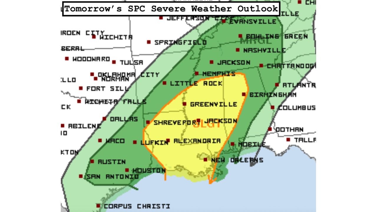
UNITED STATES — The latest Storm Prediction Center (SPC) outlook shows little change in the overall severe weather setup for Friday, with a broad Slight Risk (Level 2) continuing from eastern Texas through Louisiana, Mississippi, Arkansas, western Tennessee, and into parts of the lower Ohio Valley. While some model guidance suggests a slightly weaker low-level response, forecasters stress that multiple rounds of storms remain possible, especially from Friday afternoon into the evening and overnight hours.
SPC Outlook Shows Persistent Severe Threat Despite Uncertainty
According to the latest SPC update, the severe weather environment remains conditionally favorable, even as some model trends point to lower instability in certain areas. This uncertainty does not eliminate the threat, particularly where moisture, wind shear, and lift continue to overlap.
The highest concern zone stretches across:
- Central and southern Mississippi
- Eastern Louisiana
- Southern and central Arkansas
- Western Tennessee, including the Memphis area
Within this corridor, storms may develop in multiple waves, increasing the potential for damaging winds and isolated tornadoes.
Damaging Winds and Tornado Risk Remain on the Table
Forecast data highlights strong wind shear across the region, which could compensate for lower instability at times. While some storms may struggle initially, any storm that becomes organized could intensify quickly.
Primary hazards include:
- Damaging wind gusts up to 60 mph
- Isolated tornadoes, with a few possible later Friday
- Brief tornado potential during early activity, especially pre-dawn
- Renewed tornado risk Friday afternoon into the evening
Forecasters note that storm mode and timing will be critical, with the most concerning window arriving later in the day as atmospheric conditions evolve.
Flash Flooding a Major Concern Across Mississippi and Louisiana
Beyond severe winds and tornadoes, heavy rainfall is emerging as a significant threat, particularly across Mississippi and eastern Louisiana.
Forecast highlights include:
- 3 to 6 inches of rain possible
- Rainfall rates of 2 to 3 inches per hour
- Elevated to significant flash flood risk
- Flooded roads and localized river rises likely
Some areas may experience training storms, where repeated rounds of rainfall move over the same locations, significantly increasing flood risk.
Storm Timing: What to Watch on Friday
Timeline based on current data:
- Pre-dawn Friday: Isolated strong to severe storms possible
- Late morning to early afternoon: Rain-dominated activity with embedded storms
- Friday afternoon into evening: Highest severe risk window
- Friday night: Storms continue eastward with lingering flood threat
Officials caution that confidence remains moderate, and forecast adjustments are still possible as new data arrives.
Why This Setup Still Matters
Even with some weakening signals in model guidance, the combination of strong wind fields, deep moisture, and a progressing frontal system keeps the severe weather threat active. Past events with similar setups have produced localized but impactful outbreaks, especially where storms can briefly organize.
Residents across the Lower Mississippi Valley and adjacent regions are urged to remain weather-aware throughout Friday.
Stay Weather-Ready
Make sure you have:
- Multiple ways to receive weather warnings
- A plan for flash flooding, especially overnight
- Awareness of changing conditions throughout the day
What are you seeing in your area — steady rain, storms, or calm conditions? Share your local updates and stay connected with ChicagoMusicGuide.com for continued coverage and regional weather updates.