
Significant Wind Damage Threat Expands Sunday Night Across Nashville, Clarksville, Bowling Green and Huntsville as SPC Raises Severe Risk to 30 Percent
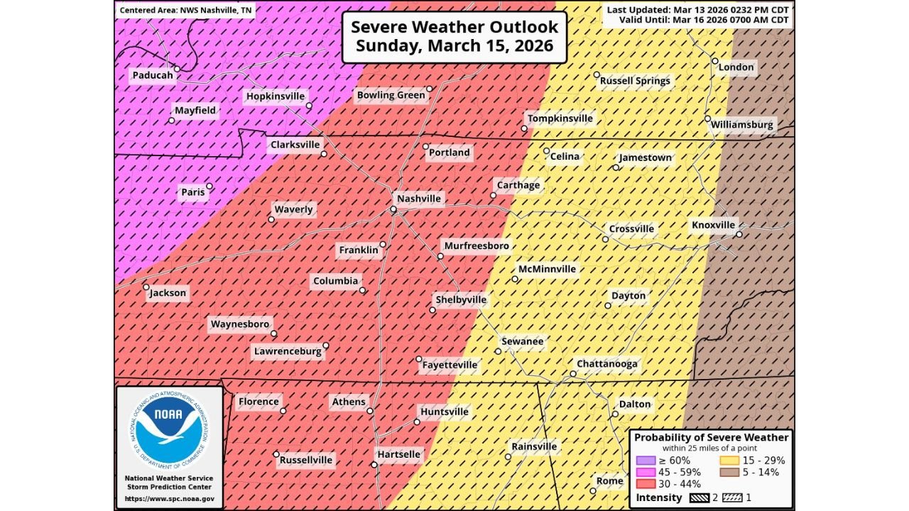
NASHVILLE, TENNESSEE — The Storm Prediction Center has increased the probability of severe weather Sunday night, raising portions of Middle Tennessee and northern Alabama to a 30 percent chance of severe storms within 25 miles of any given point — a notable escalation in concern as a powerful storm system approaches.
The updated outlook highlights a growing damaging wind threat, with forecasters warning that straight-line wind damage could become both significant and widespread.
30 Percent Severe Probability Now in Place
The expanded 30 percent zone now includes:
- Nashville
- Clarksville
- Bowling Green
- Franklin
- Murfreesboro
- Columbia
- Shelbyville
- Huntsville
- Hartselle
The hatched overlay across parts of this region indicates the potential for enhanced wind intensity — meaning damaging gusts could be severe enough to cause widespread tree damage, structural impacts and power outages.
Forecasters emphasize that the primary hazard appears to be straight-line winds rather than large hail or discrete supercell tornadoes, though brief embedded tornadoes cannot be ruled out.
Damaging Wind Event Could Be Significant
This setup favors a fast-moving squall line capable of producing strong, concentrated wind swaths.
In past events of similar structure, communities have experienced:
- Numerous downed trees
- Power outages lasting several hours
- Structural roof damage
- Travel disruptions
The wind threat is expected to peak Sunday night as the line moves eastward across Middle Tennessee into northern Alabama.
Surrounding Areas Also at Risk
Areas to the west, including Paducah, Mayfield and Paris, fall within even higher probability zones for severe weather, while areas farther east — including Crossville, Chattanooga and Knoxville — remain in the 15–29 percent range.
The gradient in risk suggests the strongest portion of the line will likely track west to east across central Tennessee before weakening slightly as it pushes toward eastern sections of the state.
Prepare Now for Possible Power Outages
Officials are urging residents to prepare today for the possibility of power outages Sunday night.
Preparation steps include:
- Charging electronic devices
- Securing loose outdoor items
- Reviewing severe weather safety plans
- Ensuring multiple methods to receive warnings
Given the emphasis on widespread wind damage potential, even residents outside the tornado-prone zones should remain alert.
Timing
Storms are expected to intensify Sunday evening and continue through the overnight hours into early Monday morning.
Conditions may deteriorate quickly once the line arrives, with short lead times between warnings and impact.
While confidence is increasing in a damaging wind event, the exact corridor of greatest impact may still shift slightly before Sunday night.
Stay with ChicagoMusicGuide.com for continuing updates as the severe weather threat develops and refined timing becomes available.