
Sneaky but Dangerous Winter Setup Targets New England and New York as Arctic Cold and High-Ratio Snow Collide This Weekend
UNITED STATES — This weekend is shaping up to be one of those classic deceptive winter setups — not a blockbuster snowstorm everywhere, but a highly dangerous mix of intense Arctic cold, strong winds, and narrow heavy snow bands that could make conditions feel extreme for parts of the Northeast.
Based on the latest data, Upstate New York, Long Island, and much of New England remain the primary targets, with additional accumulating snow possible into New York City, eastern Pennsylvania, New Jersey, and especially the Jersey Shore. While totals may not be widespread, localized plowable snowfall is firmly on the table, and some areas could see 6 inches or more — with isolated totals exceeding 8 inches where bands persist.
Why This Setup Is So Dangerous Even If Snow Totals Vary
Meteorologists are stressing that this event isn’t about widespread snowfall amounts — it’s about impact.
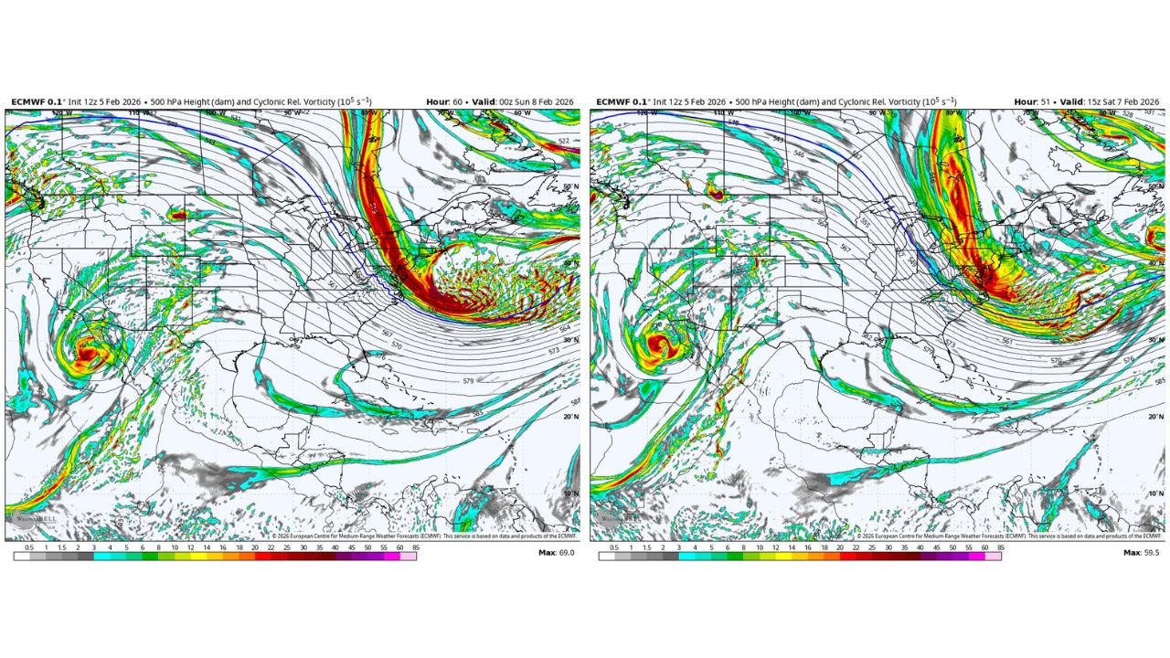
A powerful upper-level disturbance, visible clearly on ECMWF 500mb vorticity guidance, is diving sharply through the Great Lakes and Northeast. This creates:
- Extremely high snow-to-liquid ratios
- Rapid banding potential
- Snow that accumulates efficiently even with limited moisture
In practical terms, you don’t need much precipitation to get meaningful snow. Even a few tenths of liquid equivalent could quickly translate into several inches where banding locks in.
That’s why forecasters are calling this setup “sneaky.” Many locations may only see 1–3 inches, but a narrow corridor — especially across eastern Massachusetts, coastal New England, parts of Long Island, and Upstate New York — could see much higher totals.
Timing: When Conditions Deteriorate the Fastest
The most impactful window looks to be Friday night through Saturday, when multiple hazards overlap:
- Snow bands developing and shifting quickly
- Strong winds increasing blowing and drifting
- Temperatures crashing rapidly behind the Arctic front
Once the cold air is fully entrenched, snow will blow easily, visibility can drop fast, and untreated roads may ice over even where totals are modest.
Cold May Be the Bigger Story Than Snow
Even more concerning than snowfall is the brutal cold pouring in behind the system.
Data shows this Arctic air mass tracing directly from the high Arctic southward into the Northeast — a long, uninterrupted path that allows it to retain strength. This helps explain why:
- Wind chills may plunge well below zero
- Some interior and higher-elevation locations could feel dangerously cold for 24 hours or more
- Frostbite risk increases rapidly with any exposed skin
This temperature pattern fits a broader theme of Winter 2025–26, which has featured extreme contrasts — unusual warmth in the western U.S. at the same time the East experiences repeated Arctic intrusions. Upper-level anomaly maps continue to show a strong ridge in the West and deep troughing in the East — not a textbook La Niña pattern, but one that favors sharp cold shots like this.
What to Watch Closely Over the Next 24 Hours
Forecasters emphasize that pinpointing exact band placement is still the biggest challenge. Small shifts could dramatically change local outcomes.
Key areas to monitor closely:
- Eastern Massachusetts and coastal New England
- Long Island and nearby coastal zones
- Upstate New York snowbelt regions
- Parts of New Jersey and eastern Pennsylvania
Even if totals remain on the lower end for many, travel impacts, blowing snow, and dangerous cold are likely for a large portion of the region.
Bottom Line
This is not a storm to judge by headline snowfall numbers alone. The combination of high-ratio snow, strong winds, and extreme cold means this weekend could feel like a full-blown winter storm for some — even if totals end up uneven and localized.
Conditions will evolve quickly, and small forecast changes could have big real-world impacts.
Stay alert, dress for dangerous cold, and be prepared for rapidly changing conditions if you’re traveling or heading out to shows, venues, or events this weekend. For continuing winter coverage and regional weather breakdowns, keep checking back with ChicagoMusicGuide.com.