
Southern California Flash Flood Emergency Intensifies as Torrential Rain Triggers Evacuations and Burn-Scar Mudslide Threat
LOS ANGELES, CALIFORNIA — Southern California is facing a rapidly escalating flash flood emergency after a powerful storm system dumped widespread, heavy rainfall across the region, triggering dangerous flooding, mandatory evacuations, and heightened mudslide risks, particularly in wildfire burn-scar areas.
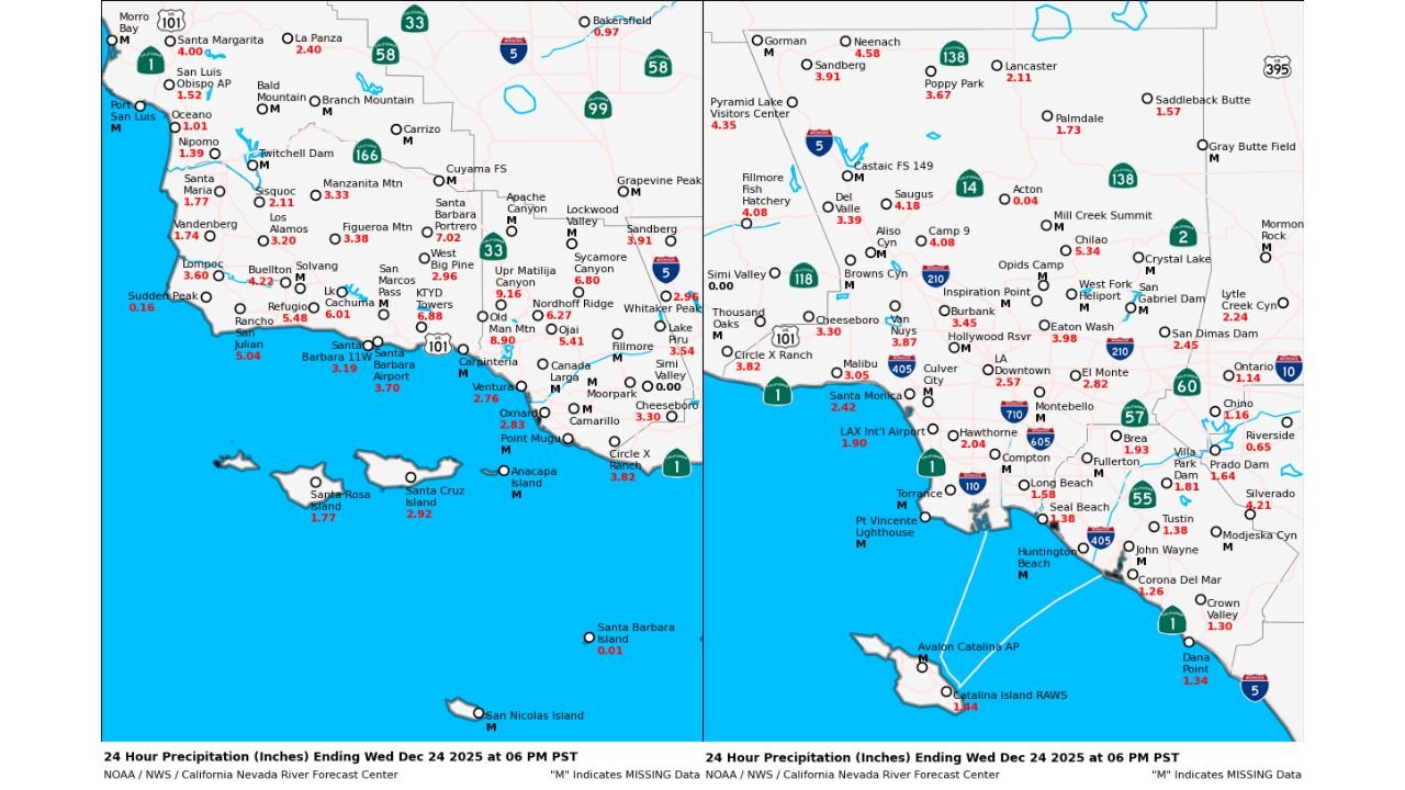
Weather data and rainfall maps show that while some locations narrowly missed worst-case forecasts, rainfall totals have still been high enough to cause serious impacts across Los Angeles, Ventura, and Santa Barbara counties. Emergency officials warn that conditions remain volatile, with additional rounds of rain expected statewide.
Flash Flooding Widespread Across Los Angeles and Ventura Counties
In the Los Angeles metro area, many communities have recorded 2 to 4 inches of rain since Tuesday evening, enough to overwhelm drainage systems and cause rapid runoff in urban neighborhoods. Low-lying roads, underpasses, and creek crossings have flooded, prompting road closures and emergency responses.
Farther northwest, mountainous areas near Ojai and the Ventura County foothills have seen significantly higher totals, with 6 to 10 inches of rain reported in less than 24 hours. These areas are especially vulnerable due to steep terrain and recent wildfire burn scars, where soil is unable to absorb water efficiently.
Mandatory Evacuations Issued Near Burn Scars and Rising Creeks
Authorities have issued mandatory evacuation orders for communities located near rapidly rising creeks, streams, and burn-scar zones, where the risk of mudslides and debris flows is highest. Even moderate additional rainfall could trigger sudden slope failures, sending mud, rocks, and debris downhill with little warning.
Emergency managers stress that burn-scar flooding behaves differently than typical rain events, with water and debris moving faster and farther than expected. Residents in evacuation zones have been urged to leave immediately and avoid returning until officials declare areas safe.
Rainfall Totals Show Sharp Local Variations
Precipitation maps from the California-Nevada River Forecast Center highlight the uneven but intense nature of this storm:
- Los Angeles Basin: Generally 1.5 to 3 inches, with isolated higher totals
- Santa Monica Mountains & Ventura foothills: 4 to 7 inches, locally higher
- Ojai and northwest Ventura County: 6 to 10 inches
- Santa Barbara County coast and hills: 3 to 6 inches
These totals fell in a short time window, increasing runoff and flash flood potential despite brief lulls in rainfall.
More Rain Expected as Storm Pattern Continues
Forecasters warn that this event is not over. Multiple additional rounds of rain are expected across Southern and Central California, raising concern that already saturated ground will be unable to handle new rainfall. Even areas that escaped major flooding during the first wave could see worsening impacts if heavier bands redevelop.
With soils saturated, any new heavy rain may lead to faster flooding than earlier in the storm, especially overnight when visibility is low.
Safety Officials Urge Extreme Caution
Emergency agencies are urging residents to take the following precautions:
- Avoid flooded roads — water depth is difficult to judge and roadways may be washed out
- Heed evacuation orders immediately, especially near burn scars
- Stay away from creeks, rivers, and drainage channels
- Remain alert overnight, when flash flooding can develop quickly
Officials emphasize that rainfall does not need to be extreme to cause life-threatening conditions in these circumstances.
What Comes Next
As the storm continues, weather officials and emergency managers will monitor rainfall trends, river levels, and hillside stability. Additional flood warnings or evacuations may be issued on short notice if conditions deteriorate.
Southern California residents are encouraged to stay informed, follow local emergency guidance, and prioritize safety as this high-impact winter storm continues to unfold.
For continuing updates, weather coverage, and safety information, follow ChicagoMusicGuide.com.