Southern Illinois and Southeast Missouri Face a Potential Moderate Risk Monday as High-Resolution Model Data Signals a Dangerous Severe Weather Environment
CARBONDALE, IL — The debate is no longer whether severe weather hits southern Illinois and southeast Missouri on Monday, April 27, 2026. The debate is how bad it gets. High-resolution model data is now printing a compelling and increasingly alarming picture for this corner of the Midwest, and theoretical risk analysis based on current atmospheric data suggests the Storm Prediction Center may be one model run away from pulling the trigger on a Moderate Risk — Level 4 of 5 upgrade for the region.
If that upgrade comes, it would place southern Illinois, southeast Missouri, and adjacent communities into one of the highest severe weather alert categories forecasters can issue.
What the Model Data Is Showing Right Now
Two of the highest-resolution short-range weather models available — the NAM 3km and the HRRR, both of which run at neighborhood-level detail and are specifically designed to capture mesoscale storm environments — are in strong agreement that the atmospheric setup across southern Illinois and southeast Missouri on Monday afternoon is exceptional. Both models are depicting an environment capable of supporting organized supercell thunderstorms with all severe weather hazards in play, including tornadoes, very large hail, and destructive winds.
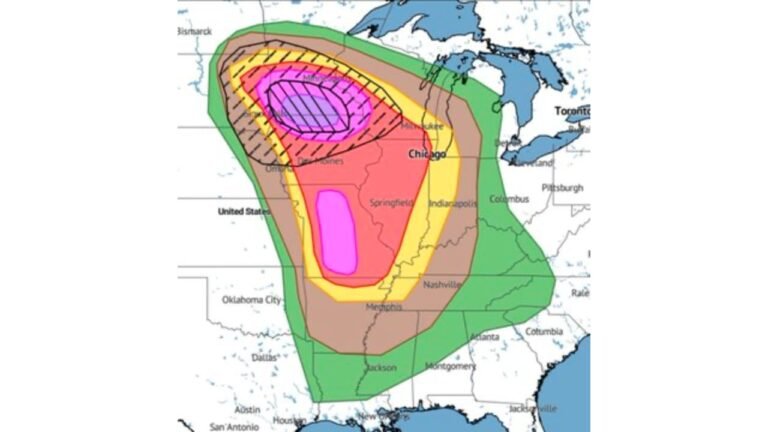
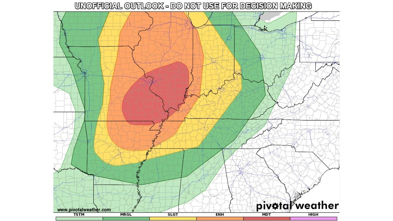
Current theoretical risk analysis places the core of the highest-threat zone — shown in deep red on the outlook display, corresponding to a Moderate Risk level — squarely over southern Illinois and extending into southeast Missouri. This red core is surrounded by an Enhanced Risk orange zone expanding across a broad corridor, with Slight Risk yellow covering much of the broader Midwest from Missouri through Indiana.
The outermost green contours extend the general thunderstorm and marginal severe threat across portions of Iowa, Wisconsin, Kentucky, Tennessee, and Arkansas — indicating the sheer geographic reach of Monday’s storm system.
The Moderate Risk Question and the Positioning Debate
Current analysis raises an important forecasting nuance: the precise positioning of the highest risk zone may need to shift. The model data argument can be made that the current theoretical placement of the Moderate Risk core may be pulled slightly too far north. The strongest atmospheric signals — including the richest instability and the sharpest low-level wind shear — are printing most prominently across southern Illinois and southeast Missouri rather than the zones farther north.
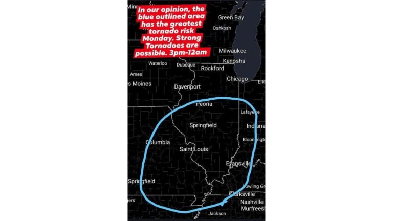
This matters because where the Moderate Risk core ultimately gets placed will determine which specific communities receive the highest-level severe weather messaging. Communities in the Carbondale, Cape Girardeau, Paducah corridor sit at the center of the atmospheric bull’s-eye based on current model data, regardless of where the official risk boundary lines are ultimately drawn.
The Storm Prediction Center will continue evaluating incoming model guidance through Sunday evening and Monday morning before issuing updated Day 1 outlooks. Each new model run brings the picture into sharper focus.
Understanding the Risk Categories on the Map
The color-coded severe weather outlook scale runs from Thunderstorm at the lowest level through Marginal, Slight, Enhanced, Moderate, and High at the top. Monday’s theoretical analysis is showing the following distribution across the region:
The deep red Moderate Risk core over southern Illinois and southeast Missouri represents a level at which widespread, organized, and potentially violent severe weather is expected. At this level, multiple tornadoes — including strong ones — along with very large hail and significant wind damage are all realistic outcomes. The Enhanced Risk orange zone surrounding it covers a large population corridor where significant severe weather is likely. The Slight Risk yellow zone extending across the broader Midwest indicates scattered severe storms are expected even on the outer edges of the system.
Threat Data and Model Comparison Table
| Data Point | Detail |
|---|---|
| Valid Period | Monday April 27 through Tuesday April 28, 2026 |
| Highest Risk Zone | Southern Illinois, southeast Missouri |
| Theoretical Peak Category | Moderate Risk — Level 4 of 5 |
| Models in Agreement | NAM 3km and HRRR both signaling strong environment |
| Primary Positioning Concern | Core may be slightly too far north — southern IL/SE MO is the target |
| Key Threat Cities | Carbondale IL, Cape Girardeau MO, Paducah KY corridor |
| All Severe Hazards | Tornadoes, very large hail, damaging winds all in play |
| Official SPC Decision | Pending — upgrade under active consideration |
State-by-State Outlook for Monday
Illinois — Southern Illinois is the state’s highest-risk zone and the focal point of current model data. Communities including Carbondale, Marion, Mount Vernon, and Benton sit inside or adjacent to the theoretical Moderate Risk core. If the Storm Prediction Center issues the upgrade, these communities will be under one of the most serious severe weather outlooks of the spring season. All residents in southern Illinois should treat Monday as a high-alert weather day regardless of the official category.
Missouri — Southeast Missouri sits directly within the high-end threat zone. The Cape Girardeau area and communities along the Mississippi River corridor are well within the bull’s-eye. St. Louis sits on the northern fringe of the Enhanced Risk zone and will need to monitor storm development throughout the day.
Kentucky — Western Kentucky including the Paducah area falls within the Enhanced Risk zone and is at risk for tornadoes and large hail as storms move northeast through the afternoon and evening.
Indiana — Southern Indiana sits within the Enhanced and Slight Risk zones on the eastern edge of the outlook. Storm activity is expected to push into this corridor during the evening hours. Evansville and surrounding communities should prepare for severe weather potential Monday evening.
Arkansas — Northern Arkansas falls within the southern fringe of the general thunderstorm and marginal risk area. Storm activity is possible, particularly along the Missouri-Arkansas border counties.
Tennessee — The outer green contours reach into northwest Tennessee. Severe weather potential increases during the overnight hours as the storm system continues tracking east.
Forecast Confidence
Confidence that southern Illinois and southeast Missouri experience significant severe weather on Monday is HIGH. The NAM 3km and HRRR models are in strong agreement on the quality of the storm environment, which is a meaningful signal at this range. Confidence in a Moderate Risk upgrade from the Storm Prediction Center is MODERATE and rising with each model run. The primary remaining variable — early-day convection and how it evolves Monday morning — continues to be the key wildcard that will determine whether the full afternoon potential is realized.
Monday is not a day to take lightly across the tri-state region of southern Illinois, southeast Missouri, and western Kentucky. The atmosphere is loaded. The models agree. The only open question is whether the official risk category catches up to what the data is already showing.
More severe weather coverage is always on the horizon. Stay informed at ChicagoMusicGuide.com — your source for Midwest outbreak tracking, model-driven storm analysis, and breaking severe weather coverage across Illinois, Missouri, and the entire United States.