
Southern Indiana, Eastern Illinois, Southwest Ohio and Northern Kentucky Face Conditional Tornado Risk Thursday With Briefly Strong EF2+ Possible
EVANSVILLE, INDIANA — A conditional but potentially dangerous severe weather setup is developing for Thursday afternoon and evening across southern Indiana, eastern Illinois, southwest Ohio, and far northern Kentucky, where a few tornadoes — including a briefly strong EF2+ — cannot be ruled out.
Forecasters emphasize this is not a guaranteed outbreak scenario. However, the environment features several classic ingredients that, if aligned properly, could support isolated supercells capable of producing tornadoes near a warm front and triple point setup.
Warm Front and Triple Point Create Focused Tornado Corridor
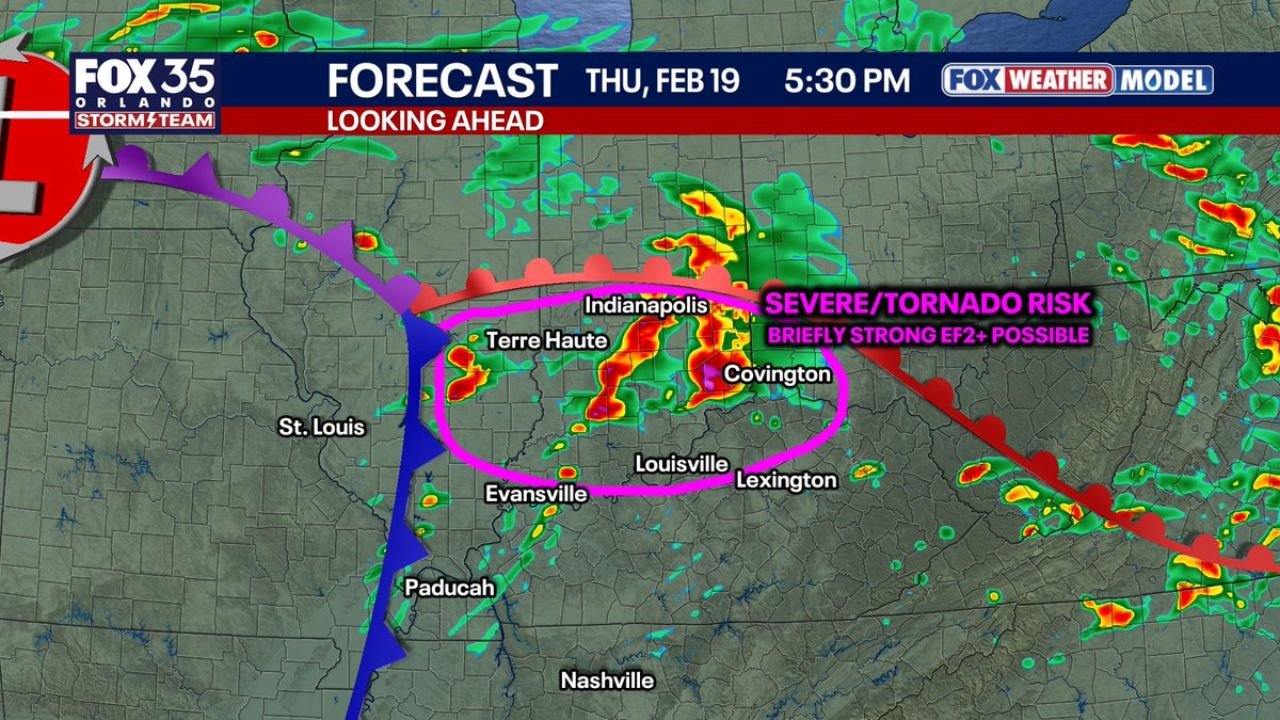
The forecast map highlights a corridor stretching from near Terre Haute and Indianapolis in Indiana, down toward Evansville, eastward into the Covington, Kentucky area, and brushing portions of southwest Ohio.
This zone lies near a warm front draped west-to-east and a developing surface low with a trailing cold front extending south toward Paducah, Kentucky. Tornadoes historically favor warm fronts and triple point configurations because they enhance low-level wind shear and directional turning of winds with height.
Southern Indiana appears to have the highest conditional risk. If a discrete supercell can form along or just south of the boundary, it could briefly intensify in an environment supportive of rotation.
Supercell Development Is the Key Uncertainty
The main question is storm mode. If storms remain clustered or linear, the tornado threat may stay limited and primarily produce gusty winds and heavy rain. However, if a storm can break away and remain isolated, the vertical wind shear in place would favor rotating updrafts.
Model projections suggest scattered storms developing in the late afternoon around Indianapolis and Terre Haute, then expanding southeastward toward Louisville and Covington by early evening.
Because this setup is conditional, small changes in instability or boundary placement could significantly alter outcomes. Even a narrow corridor of enhanced heating could locally increase the risk.
Timing and What to Watch For
The greatest window for severe weather appears to be between mid-afternoon and early evening Thursday. Residents across southern Indiana, eastern Illinois, southwest Ohio, and northern Kentucky should monitor conditions closely during this period.
Key factors that will determine severity include:
- The exact placement of the warm front
- How much surface instability develops
- Whether storms remain discrete or quickly merge
- The strength of low-level wind shear near sunset
Given the potential for fast-evolving storms, having multiple ways to receive weather alerts is essential.
Not a Slam-Dunk Outbreak — But Worth Attention
While instability may be modest for this time of year, the wind profile is supportive enough that any storm that organizes could briefly produce a tornado. The phrase “conditional risk” applies strongly here — the ingredients are present, but they must come together precisely.
Southern Indiana currently appears to be the most favored area for any stronger tornado potential, though eastern Illinois, southwest Ohio, and northern Kentucky remain in play.
Stay with ChicagoMusicGuide.com for updated severe weather coverage and detailed breakdowns as confidence increases and new model data becomes available.