
Tennessee–Arkansas–Mississippi Weather Outlook Shows Limited Snow Potential as December Pattern Brings Only Clippers and Deep Cold Across the Mid-South
TENNESSEE — A new long-range weather outlook suggests the Mid-South is unlikely to see a significant snow event over the next two weeks, despite a colder pattern taking shape across much of the central United States. Forecast data and ensemble model maps indicate that while the region will turn sharply colder, snow accumulation chances remain minimal.
Model Guidance Shows No Strong Window for Major Snow
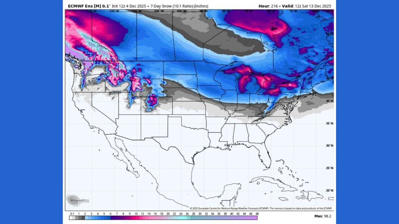
Meteorologists analyzing the latest ECMWF ensemble output report no solid timeframe for a meaningful winter storm across the Mid-South. While temperatures will support wintry weather, the atmospheric pattern needed for a widespread snow event simply isn’t aligning at this stage of December.
The model map included in the outlook shows heavier snow confined to the Upper Midwest, Great Lakes, and northern Plains, with only minor, localized flurries making it into the central U.S.
This suggests that regions such as Tennessee, Arkansas, northern Mississippi, and western Kentucky are unlikely to see measurable snow in the near term.
Fast-Moving Clippers Could Bring Light Flurries Further South
Although a major storm appears unlikely, forecasters note that the evolving upper-air pattern will allow multiple Alberta clippers to sweep across the central and eastern U.S.
These systems are typically:
- Fast-moving
- Low moisture
- More associated with sharp temperature drops than heavy snow
While these clippers may drop a few flurries or a dusting as they dive southward, current guidance shows nothing substantial developing.
MJO Progression Points to a Prolonged December Cold Stretch
Based on the current phase of the Madden–Julian Oscillation (MJO), meteorologists expect the region to remain steadily cold through the end of the month.
This reinforces the idea that while the atmosphere will be supportive of chilly conditions, the moisture pathways needed for organized snowstorms will remain limited.
The result:
- Cold air dominates,
- Snow chances stay low,
- Clipper-driven flurries remain the only realistic short-term possibility.
What This Means for Residents Across the Mid-South
As December progresses, residents should prepare for:
- Colder daytime highs
- Freezing overnight lows
- Wind-driven chill factors during clippers
- Minimal snow accumulation
While winter weather enthusiasts may be hoping for a bigger system, model consensus currently favors quiet conditions with no major threats.
How is the early-winter pattern shaping up where you live? Share your local weather observations and join the conversation on ChicagoMusicGuide.com.