
Texas, Illinois, Ohio, Pennsylvania, and Georgia Head Toward a Broad January Warm-Up as Pacific Jet Reshapes U.S. Weather Pattern
UNITED STATES — A widespread temperature reversal is shaping up across much of the lower 48 states next week, as forecast data shows a strong Pacific jet stream pushing warmer air eastward and temporarily shutting down sustained cold across large portions of the country.
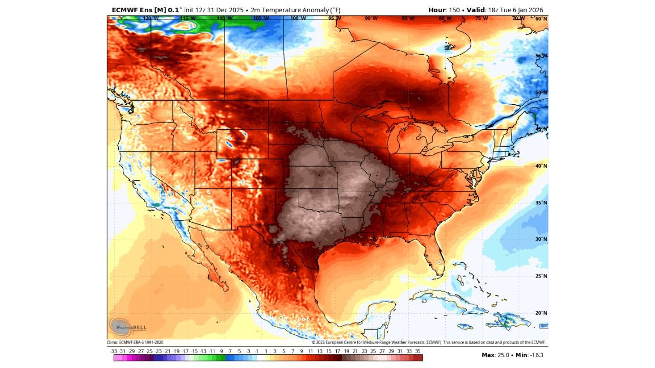
Multiple long-range model signals indicate that most regions of the central, southern, and eastern United States are likely to experience above-normal temperatures as we move deeper into early January. This pattern marks a notable pause after recent cold intrusions and winter storms affecting parts of the Midwest and East.
Pacific Jet Stream Driving the Warm Pattern
Forecast guidance shows a ridge building eastward from the Pacific, allowing milder air to flood across the interior United States. Temperature anomaly maps highlight strong positive departures from normal, especially across the Plains, Midwest, Ohio Valley, and much of the South.
This setup limits the ability of Arctic air to move south, keeping sustained cold locked farther north and delaying any major winter pattern reset.
Cold Air Signal Delayed Until Mid-January
While colder air does appear in extended model output, it remains long-range and uncertain. Ensemble data suggests that a shift toward colder conditions across the central and eastern U.S. could develop later in January, but confidence is low at this time.
One key factor adding uncertainty is the Madden-Julian Oscillation (MJO), which remains stuck near the “null zone.” When the MJO lacks a clear phase, models often struggle to lock in timing and intensity for pattern changes, making exact outcomes difficult to pin down.
Greenland Blocking Could Change the Setup Later
Some ensemble members hint that stronger blocking near Greenland could emerge by mid-month if favorable teleconnections develop. If that occurs, colder air could return more forcefully to the eastern half of the country. For now, however, the dominant signal favors warmth rather than renewed winter extremes.
What This Means for the Week Ahead
- Milder temperatures for much of the lower 48
- Reduced risk of widespread snow and ice in the short term
- Higher uncertainty beyond the second week of January
- Potential pattern flip later, but not locked in yet
This evolving setup is one to watch closely, especially as we move deeper into the heart of winter and seasonal expectations clash with short-term warmth.
If you’re tracking how this shifting pattern could affect concerts, travel, or outdoor plans in the weeks ahead, stay tuned for continued updates. You can follow more weather breakdowns and regional outlooks right here on ChicagoMusicGuide.com as new data comes in.