
Texas, Louisiana, Mississippi, Alabama, Georgia, and Florida Face Rare Winter Ice and Tornado Threat as Storm Prediction Center Issues Late-Night Alert
UNITED STATES — A powerful and unusually complex January storm system is creating a sharp and dangerous divide across the southern United States, with freezing rain and sleet impacting large parts of Texas and Louisiana while a separate tornado risk zone develops just to the east across Mississippi, Alabama, Georgia, and northern Florida. The Storm Prediction Center (SPC) has issued a late-night Mesoscale Discussion highlighting the growing concern for freezing rain overnight into Sunday, even as severe weather ingredients intensify nearby.
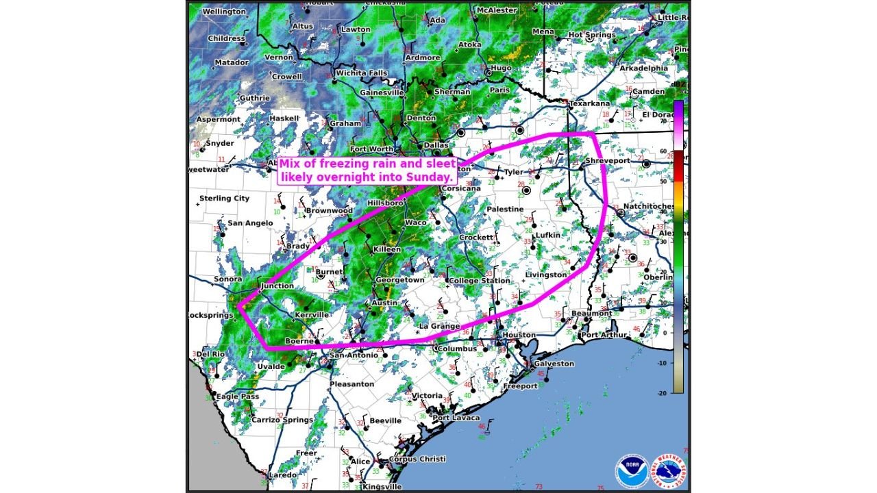
Radar imagery and surface observations show a broad shield of precipitation stretching from South-Central Texas through North Texas and into western Louisiana, with temperatures hovering near or below freezing north of the Interstate 10 corridor. At the same time, stronger winds and warmer air are advancing east of the frozen zone, creating a rare mid-winter overlap of hazards.
Mesoscale Discussion Highlights Overnight Freezing Rain Threat
The SPC’s Mesoscale Discussion #50, valid into the early morning hours, specifically flags a mix of freezing rain and sleet likely overnight into Sunday across a large portion of Texas, extending into western and northern Louisiana. The outlined zone includes cities and communities near Austin, Waco, Killeen, Georgetown, Hillsboro, Dallas–Fort Worth, Tyler, and Shreveport.
Meteorologists note that precipitation rates may increase overnight, raising the risk for:
- Ice accumulation on bridges, overpasses, and untreated roads
- Tree damage and power outages, especially where ice builds on already weakened limbs
- Dangerous travel conditions developing rapidly after midnight
Even areas that initially see rain may transition to freezing rain as surface temperatures drop, making conditions particularly deceptive for overnight drivers.
Central and South Texas Caught in the Transition Zone
Central Texas sits near the heart of this evolving storm, where surface temperatures vary sharply over short distances. Communities from San Antonio north toward Austin and Georgetown are experiencing periods of cold rain, with freezing rain possible in elevated or inland areas as colder air continues to press southward.
Farther west, locations near Junction, Kerrville, and Brady are seeing more persistent wintry precipitation, including sleet and freezing rain. These areas are at higher risk for ice accretion on power lines and secondary roads, especially as precipitation continues through the early morning hours.
Just Miles East, Severe Weather and Tornado Risk Increases
What makes this storm especially noteworthy is how quickly conditions change east of the freezing line. Less than 100 miles from the ice storm zone, warmer and more unstable air is spreading northward across southern Mississippi, Alabama, and parts of Georgia and the Florida Panhandle.
Forecasters warn that strong wind shear combined with increasing moisture could allow isolated severe thunderstorms, including the possibility of a brief but potentially strong tornado, even during the overnight period. January tornado risks are uncommon but historically most likely in the Deep South when Gulf moisture surges north ahead of a strong winter system.
Why This Storm Stands Out in January
This event underscores how volatile winter weather can become across the southern U.S. Unlike classic winter storms confined to snow and ice, this system features:
- A shallow but persistent cold air mass locked in across Texas and Louisiana
- Strong upper-level winds promoting wind shear farther east
- A tight temperature gradient, allowing winter weather and severe storms to coexist nearby
Such setups are challenging to forecast and can evolve quickly, making real-time monitoring critical for both emergency managers and residents.
What Residents Should Prepare For Overnight
Officials urge residents across the affected states to remain weather-aware through the night and into Sunday. Those in ice-prone areas should avoid unnecessary travel, especially during the overnight and early morning hours when road conditions are hardest to assess. In tornado-prone regions, having multiple ways to receive warnings — including weather radios and mobile alerts — is strongly recommended, particularly while sleeping.
As this storm system continues to shift eastward, impacts may change rapidly from county to county. Continued updates and refinements to warnings are expected as temperatures and precipitation evolve.
As the southern United States navigates this rare and dangerous January weather setup, staying informed will be key to minimizing risk. For continued coverage of winter storms, severe weather threats, and regional impacts across the country, visit ChicagoMusicGuide.com for the latest updates.