
Texas, Oklahoma, Arkansas, Tennessee, North Carolina and Virginia Face Expanding Major January Winter Storm With Heavy Snow, Ice and Dangerous Cold
UNITED STATES — A large and increasingly impactful January winter storm is coming into sharper focus across a wide stretch of the country, with updated guidance showing heavy snow, dangerous ice, and prolonged cold affecting multiple regions from Texas and Oklahoma through the Mid-South, Appalachians, and into the Mid-Atlantic and New England from Friday through early next week.
Latest forecast data, ensemble guidance, and national hazard outlooks all point toward a multi-day, high-impact winter event, with travel disruptions, power outage risks, and hazardous wind chills becoming more likely as confidence continues to rise.
Storm Setup: Why This System Is Gaining Strength
Forecast models show very cold Arctic air already in place, with only brief moderation midweek before another surge of cold locks in ahead of the storm. This setup creates a classic clash between deep cold air at the surface and moisture riding along the southern jet stream, a combination that favors widespread snow north of the storm track and significant freezing rain to the south.
While model spread still exists, forecasters agree that enough ingredients are present to support a high-end winter weather event, even if exact placement of the heaviest snow and ice shifts slightly over the coming days.
Heavy Snow Threat: Plains to the Mid-Atlantic
Snowfall potential stretches from the Southern Plains into the Ohio Valley, Appalachians, Mid-Atlantic, and New England, with moderate to high confidence in widespread accumulations.
Key snowfall highlights include:
- Oklahoma and North Texas: Areas north of the main ice zone could see 6 to 12 inches of snow, particularly across southern Oklahoma, where confidence in double-digit totals is highest.
- Arkansas, Tennessee, and Kentucky: A broad swath of significant snow is likely, with travel-impacting accumulations and snow-covered roads becoming widespread.
- Virginia, West Virginia, and North Carolina high terrain: Snow probabilities increase sharply along the Cumberland Plateau and Blue Ridge, with several inches possible.
- Mid-Atlantic and Northeast: Guidance supports moderate to heavy snow from portions of Pennsylvania and New Jersey into New York and New England, especially in higher elevations.
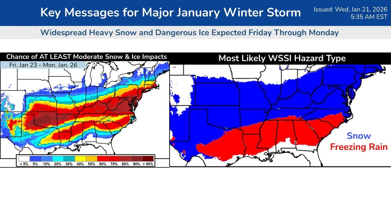
Ensemble probability maps show a 30–50% chance of at least 6 inches of snow along a long corridor from the Southern Plains to the East Coast, underscoring the storm’s expansive reach.
Dangerous Ice Zone: Southern Plains to the Carolinas
South of the heavy snow band, freezing rain and sleet pose one of the most serious threats with this system.
Areas at highest risk include:
- Northern Texas and southern Oklahoma
- Southern Arkansas and northern Mississippi
- Alabama, Georgia, and the Carolinas
Even light ice accumulations can lead to impassable roads, downed trees, and power outages, especially when combined with strong cold advection behind the storm. Forecasts indicate that freezing rain may overlap regions already dealing with heavy snow, compounding impacts.
Cold Air and Wind Chills Add to the Danger
Behind the storm, hazardous cold is expected to linger, with wind chills falling well below actual air temperatures.
- Many areas could see single-digit temperatures, with below-zero wind chills possible in colder air masses.
- The persistence of cold increases the risk of prolonged icing, refreezing of roads, and extended infrastructure stress.
- Power outages, if they occur, become far more dangerous due to the lack of reliable heat in affected communities.
Forecasters stress that cold impacts may last longer than the snowfall itself, making preparation critical.
Timing: When Impacts Begin and End
- Friday: Snow and ice develop across the Southern Plains and Mid-South late in the day.
- Saturday: Peak impacts expand eastward, with widespread snow, ice, and travel disruptions.
- Sunday into Monday: The storm reaches the East Coast and New England, while cold air deepens behind the system.
Some regions may experience multiple rounds of winter weather, rather than a single burst.
How This Compares to Past Events
Officials note that while this storm is not a repeat of February 2021, particularly for Texas, the combination of cold and winter precipitation is enough to cause significant disruptions, especially across the northern half of Texas and nearby states. The key difference lies in duration and placement, but impacts could still be serious.
Preparation and Safety Guidance
With confidence increasing, now is the time to prepare:
- Adjust travel plans early, especially for Friday night through Sunday.
- Protect pipes, pets, plants, and vulnerable individuals from prolonged cold.
- Ensure you have multiple ways to receive weather alerts, including mobile alerts and local updates.
- If you rely on electricity for heat, identify backup shelter options ahead of time.
Forecasters emphasize that exact snow and ice lines will continue to shift, but the overall threat is real and growing.
What to Watch Going Forward
Over the next 24–48 hours, expect refinements to:
- The axis of heaviest snow
- The extent of the freezing rain corridor
- Localized snowfall totals
Even small shifts could make a major difference at the community level, so staying informed is essential.
Stay Connected
This storm has the potential to impact millions across multiple states. We’ll continue tracking updates, impacts, and timing changes as confidence increases.
Are you in the projected snow or ice zone? How are you preparing for the weekend storm?
Share your thoughts and stay updated with ongoing weather coverage on ChicagoMusicGuide.com.