
Texas, Oklahoma, Kansas and Missouri Bracing for Increasing Severe Storm Potential March 6–11 as Western Trough Fuels Multi-Day Thunderstorm Pattern
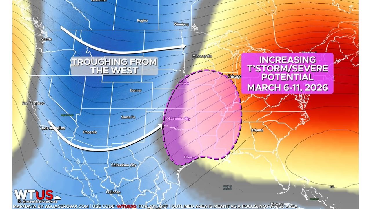
UNITED STATES — A prolonged western U.S. trough combined with strengthening Gulf moisture return is setting the stage for an increasingly favorable severe weather pattern from March 6 through March 11, particularly across Texas, Oklahoma, Kansas and Missouri, with impacts potentially extending into Arkansas, Illinois and the Mississippi Valley.
Forecast guidance shows a broad zone from the southern Plains into the central U.S. where thunderstorm and severe weather potential may steadily increase through the weekend and into next week.
Western Trough Setting the Stage
The large-scale setup shows:
- Deep troughing anchored over the western United States
- Strong southwest flow emerging across the Plains
- Warm, moist air surging north from the Gulf of Mexico
This combination is often associated with active severe weather periods across Texas and Oklahoma, especially when instability overlaps with strengthening wind shear.
The highlighted focus zone stretches from north Texas and central Texas through Oklahoma City, into southern and eastern Kansas, and northeast toward western Missouri.
Primary Corridor: Texas Through Missouri
Based on the data shown, the most favorable severe corridor includes:
- Houston and north Texas
- Oklahoma City and central Oklahoma
- Southern and eastern Kansas
- Western and central Missouri
- Parts of Arkansas
This region lies in the overlap of increasing moisture and dynamic upper-level energy. As the trough ejects disturbances eastward, multiple rounds of thunderstorms are possible.
Multi-Day Window March 6–11
Rather than a single outbreak day, models suggest an active stretch spanning several days.
That means:
- Repeated thunderstorm clusters
- Potential supercell development
- Organized squall lines
- Shifting severe zones depending on each wave
Exact timing for peak severe days remains uncertain, but the overall pattern supports a sustained active period.
Mississippi Valley and Midwest Also in Play
As the western trough progresses, severe potential could expand into:
- Arkansas
- Missouri
- Illinois
- Possibly parts of Indiana
Chicago currently sits near the northern edge of the highlighted region. While the strongest parameters are focused farther south and west, any northward moisture surge or stronger disturbance could bring stronger thunderstorms into parts of Illinois later in the window.
Why This Pattern Raises Attention
Key ingredients include:
- Anomalously strong Gulf moisture return
- Persistent upper-level troughing from the west
- Favorable jet stream alignment
This setup is historically associated with early-season Plains severe weather episodes.
However, forecasters caution that small-scale details — such as surface boundaries and timing of each disturbance — will determine the magnitude and exact location of any severe events.
Monitoring Trends Closely
Confidence is growing in an active rain and thunderstorm period from the southern Plains through the Mississippi Valley, potentially nudging into the Midwest.
Residents across Texas, Oklahoma, Kansas, Missouri and Arkansas should monitor forecast updates as the March 6–11 window approaches. Specific severe outlooks and risk levels will become clearer as we move closer to the event timeframe.
For continuing updates on this developing severe weather pattern and its potential impacts across the central United States, stay with ChicagoMusicGuide.com.