
Texas, Oklahoma, Kansas, and the Central U.S. Could See Much-Needed Early April Rains as Storm Pattern Signals Rising Severe Weather Risk
DALLAS, TEXAS — Forecast models are showing encouraging rainfall trends for portions of the Central United States heading into early April, particularly across Texas, Oklahoma, and Kansas, where recent dry stretches have raised concerns. Ensemble guidance suggests above-normal precipitation between late March and early April, though confidence remains lower across parts of the Northwest Plains.
The emerging pattern indicates a shift toward a more active storm track across the Southern Plains, which could bring meaningful rainfall opportunities — but also a noticeable uptick in severe weather risk.
Southern Plains Positioned for Above-Normal Rainfall
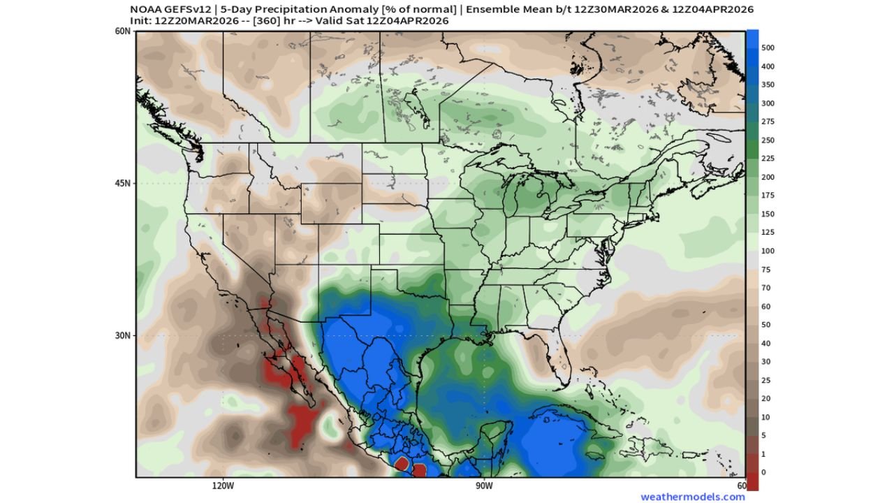
Both European and American ensemble guidance indicate precipitation totals exceeding seasonal averages across large portions of Texas, extending north into Oklahoma and Kansas.
Forecast anomaly maps show broad areas shaded in green and blue across the Southern Plains, signaling rainfall totals running well above normal for the period. This is particularly significant for parts of central and eastern Texas, where repeated storm systems may track across the region.
The projected rainfall corridor also stretches eastward toward portions of the Lower Mississippi Valley, reinforcing the idea that early April could bring a more favorable moisture pattern to areas that have recently trended dry.
Northwest Plains Rainfall Remains Uncertain
While confidence is higher in improved rainfall chances across the Southern Plains, the outlook is less optimistic for parts of the Northwest Plains, including sections of Montana and the Dakotas.
Precipitation anomaly guidance shows more muted signals in those regions, with some areas remaining near or slightly below seasonal averages. This suggests that while the overall Central U.S. pattern becomes more active, the northern tier may not benefit equally from the upcoming storm track.
Meteorologists caution that ensemble means represent broad averages and that localized variations are still possible. However, the current signals clearly favor the Southern Plains over the far northern Plains for meaningful rainfall increases.
Active Storm Pattern Likely to Increase Severe Weather Risk
An uptick in rainfall during late March and early April often coincides with a more energetic atmospheric pattern. The same storm systems delivering beneficial rain to Texas and Oklahoma could also support strong to severe thunderstorms.
With increasing Gulf moisture return and strengthening upper-level dynamics, the Central U.S. could see a rise in:
- Severe thunderstorm outbreaks
- Large hail and damaging wind potential
- Isolated tornado risks
- Heavy rainfall leading to localized flooding
Forecasters emphasize that beneficial rains and severe weather frequently go hand-in-hand during spring transition periods across the Plains.
Early April Could Mark a Pattern Shift
The broader atmospheric setup suggests a more progressive and storm-active pattern compared to recent weeks. Repeated disturbances moving through the Southern Plains would provide multiple opportunities for rain across Texas, Oklahoma, and Kansas.
If the trend holds, this period could significantly improve soil moisture and drought conditions in parts of the Central U.S. However, the trade-off may be increased severe weather episodes as spring instability builds.
Residents across the Central United States should monitor forecast updates closely as early April approaches. While the rainfall outlook is promising for drought relief in parts of Texas and the Southern Plains, the evolving storm pattern also signals heightened severe weather potential.
For continued updates on national weather trends, rainfall projections, and severe storm outlooks, visit ChicagoMusicGuide.com.