
Tornadoes Possible Along I-70 East of Effingham, Illinois as Midwest Warm Front Setup Raises Conditional Strong Risk
EFFINGHAM, ILLINOIS — A volatile severe weather setup is developing across parts of the Midwest and Ohio Valley, with tornadoes possible tomorrow afternoon, particularly along and east of the I-70 corridor near Effingham, Illinois. Forecasters indicate that any supercells that form could track eastward, posing a risk for rotating storms across central and eastern Illinois and into Indiana.
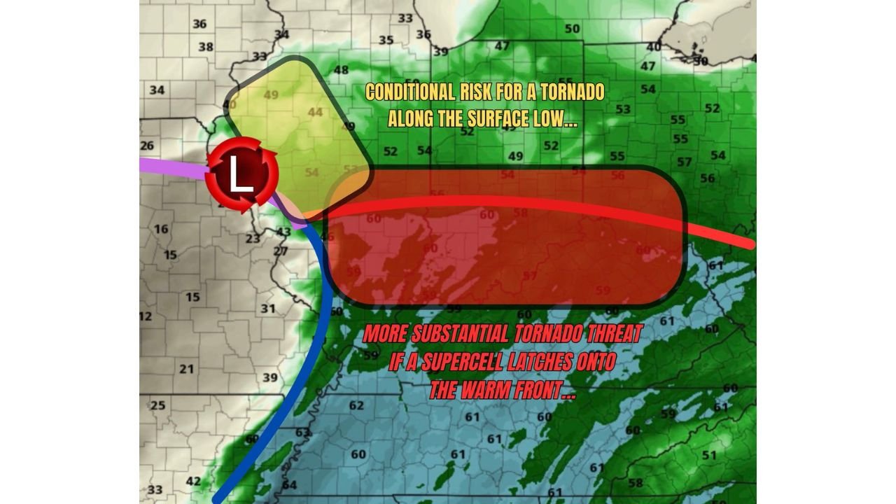
While not a guaranteed outbreak scenario, the environment shows ingredients that could support tornado development — including a conditional risk for a strong tornado if storms interact favorably with the warm front.
Warm Front and Surface Low Create a Focused Tornado Corridor
The projected surface map shows a low-pressure center positioned west of Illinois, with a warm front extending eastward across central Illinois into Indiana and the Ohio Valley. This boundary is critical.
Areas along and just north of the warm front often experience enhanced wind shear and directional turning in the lower atmosphere. If a supercell “latches onto” that boundary, storm rotation can intensify quickly.
The highlighted tornado risk zone stretches from east of Effingham along I-70, potentially impacting communities across east-central Illinois and into western Indiana as storms track east.
Conditional Strong Tornado Risk Depends on Storm Mode
Forecasters emphasize that this is a conditional setup. That means tornado potential hinges on how storms organize.
If storms remain scattered and discrete, supercells may develop ahead of the main line. In that scenario, a storm interacting directly with the warm front could produce a more substantial tornado threat.
However, if storms merge into clusters or a solid line too quickly, the tornado risk could be reduced in favor of damaging wind gusts.
The key factor will be whether a single storm can remain isolated long enough to tap into enhanced low-level shear along the boundary.
Midwest and Ohio Valley in Broader Severe Weather Zone
Beyond Illinois, the severe setup expands across parts of the Ohio Valley, including areas of Indiana and possibly western Ohio, as storms continue eastward.
Temperatures south of the warm front are expected to remain in the upper 50s to lower 60s, indicating sufficient low-level moisture for organized convection. Meanwhile, cooler air north of the boundary sharpens the contrast, increasing the potential for localized rotation near frontal intersections.
Communities across central Illinois, eastern Illinois, and into Indiana should monitor conditions closely during the afternoon and early evening hours.
Timing and Impact Window
The primary tornado window appears to be tomorrow afternoon, with storms likely initiating west of the I-70 corridor before moving east.
Areas east of Effingham, Illinois, including locations along I-70, could experience rapidly intensifying storms if atmospheric destabilization reaches its peak during this time.
Primary hazards include:
- Isolated tornadoes
- Damaging wind gusts
- Large hail
- Rapidly changing visibility in heavy rain
Because this setup depends heavily on storm structure and boundary interaction, forecast updates will be critical.
As the Midwest prepares for a potentially dynamic severe weather day, residents along and east of the I-70 corridor in Illinois and into Indiana should ensure they have multiple ways to receive warnings. For continued severe weather updates and detailed regional analysis, visit ChicagoMusicGuide.com for the latest coverage.