Two Models Flag a Potential Tropical Development Off Florida’s West Coast by Thursday June 4 as Hurricane Season Opens
TAMPA, FL — On the opening day of the 2026 Atlantic Hurricane Season, two independent high-resolution models are pointing at the same concerning signal — a piece of energy trying to organize off the west coast of Florida by Thursday, June 4, 2026. While conditions are currently unfavorable for tropical development, current analysis confirms that small pockets of lower wind shear could allow a small system to take shape over the eastern Gulf of Mexico.
What Two Models Are Showing
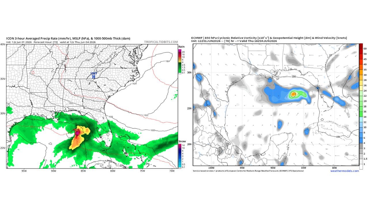
The ICON model initialized June 1, 2026 at 12Z, valid for Thursday, June 4 at 12Z, shows a well-defined low pressure center developing over the eastern Gulf of Mexico just west of Florida’s Gulf Coast. The precipitation rate display shows an intense core of heavy rainfall in orange and magenta centered on the circulation, with a broad green rainfall shield spreading northward toward Louisiana, Mississippi, and Alabama and eastward toward Tampa and the Florida Peninsula.
The surface pressure analysis on this model run shows isobars tightening around a 1000 to 1012 millibar circulation center positioned near the Florida-Alabama border region in the Gulf, a classic early-season Gulf of Mexico development position.
The European model’s 850 millibar cyclonic relative vorticity analysis valid Thursday, June 4 at 18Z tells the same story. An orange-shaded vorticity maximum — indicating a concentrated area of atmospheric spin at roughly 5,000 feet above the surface — is clearly depicted off the west coast of Florida, surrounded by a broad zone of elevated cyclonic vorticity in green and blue extending across the northern and eastern Gulf. This is the atmospheric signature of a developing or developing-adjacent tropical circulation.
Why This Is Worth Watching Despite Unfavorable Conditions
Current large-scale conditions are not ideal for tropical development. El Nino influence is maintaining elevated wind shear across portions of the Gulf of Mexico, which disrupts tropical circulations before they can organize vertically. However, current analysis specifically identifies small pockets of locally reduced wind shear in the eastern Gulf where a compact, small-scale system could still develop and maintain itself even within a broader hostile environment.
This is not unprecedented. Small Gulf systems have formed and caused significant rainfall impacts on Florida and Gulf Coast states even during periods of otherwise unfavorable large-scale conditions. The compactness of the potential circulation actually works in its favor in a high-shear environment.
Potential Impacts if a System Develops
| Impact Type | Affected Area | Threat Level |
|---|---|---|
| Heavy rainfall | West Florida coast, Tampa Bay area | Moderate to High |
| Flooding | Coastal and low-lying areas, west FL | Moderate |
| Tropical storm force winds | Near any developing center | Low to Moderate |
| Gulf Coast rainfall | Louisiana, Mississippi, Alabama | Low to Moderate |
Forecast Confidence
Confidence in some form of surface circulation developing in the eastern Gulf of Mexico by Thursday, June 4 is LOW to MODERATE based on the model agreement shown. Confidence in this reaching tropical storm or named storm status is LOW given the unfavorable large-scale wind shear environment. Confidence in heavy rainfall impacting Florida’s west coast and portions of the northern Gulf Coast during this period is MODERATE regardless of whether formal tropical development occurs.
This is the first notable tropical development signal of the 2026 hurricane season. Monitor closely as Thursday approaches.
More tropical weather coverage is always on the horizon. Stay informed at ChicagoMusicGuide.com — your source for Gulf of Mexico tropical tracking and breaking weather coverage across Florida, the Gulf Coast, and the entire United States.