
Upper Midwest, Ohio Valley, and New England Face Strongest Late-December Cold Blast as Arctic Air Pushes South
CHICAGO, ILLINOIS — Forecast data points to a significant Arctic cold blast developing at the end of December, with the Upper Midwest, Ohio Valley, and New England emerging as the regions most likely to experience below to well-below average temperatures as 2025 transitions into early January. Current model trends suggest the cold air arrives around December 30, lasting through January 2, with potential extension toward January 6 if an additional cold surge materializes.
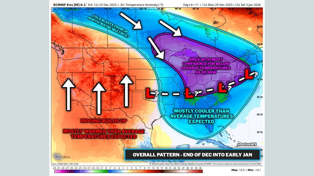
While temperature contrasts will exist across the country, confidence is highest that the central and eastern United States—particularly the Midwest corridor eastward—will bear the brunt of the cold.
Upper Midwest Likely to See the Coldest Conditions
Among all regions, the Upper Midwest shows the highest confidence for sustained and significant cold. Areas including Illinois, Wisconsin, Minnesota, Iowa, and Michigan are positioned directly beneath the core of the Arctic air mass.
Temperature anomaly projections indicate persistent below-average readings, with some locations potentially running 10 to 20 degrees colder than normal for several days. Cities such as Chicago, Milwaukee, Minneapolis, and Madison are likely to feel the sharpest impacts, including overnight lows dipping well below freezing and daytime highs struggling to recover.
This setup is typical of strong Arctic highs, which can lock cold air in place and suppress warmer air from returning quickly.
Ohio Valley Expected to Remain Locked in Cold Air
South and east of the Midwest, the Ohio Valley is also forecast to experience prolonged cold conditions. States including Indiana, Ohio, Kentucky, and western Pennsylvania fall within the zone highlighted for below-average temperatures.
Forecast guidance suggests the cold air will not be fleeting, with multiple days of chilly daytime highs and cold nighttime lows. While the cold may not be as extreme as in the Upper Midwest, it is expected to be persistent, increasing heating demand and raising the potential for cold-related travel concerns.
Meteorologists are also monitoring whether storm energy could interact with this cold air along its southern edge, though confidence in specific storm development remains limited at this time.
New England Faces Cold Push Into Early January
Farther east, New England—especially interior and northern sections—is also within the core zone for below-average temperatures. States such as Vermont, New Hampshire, Maine, and interior Massachusetts are projected to see notably colder than normal conditions heading into the new year.
Coastal areas may experience some moderation at times, but inland locations are likely to remain firmly entrenched in winter-like cold. The cold pattern could linger longer here if Arctic high pressure remains anchored over eastern Canada.
Western U.S. Stays Milder by Comparison
In contrast to the eastern half of the country, the western United States is expected to remain mostly warmer than average. A developing ridge of high pressure should promote milder conditions across much of the Southwest, Great Basin, and interior West, with only limited exceptions along parts of the coast and higher elevations.
This strong west-east contrast reinforces the likelihood that cold air will remain concentrated over the Midwest and East rather than spreading nationwide.
Storm Track Uncertainty Remains
Although cold air will be firmly in place, models are still uncertain about whether southern-stream energy will interact with the Arctic air mass. Early signals suggest the first cold push may suppress storm development, pushing energy farther south.
Forecasters will closely watch the final days of December, as any shift in pressure patterns could open the door for snow or mixed precipitation events across parts of the Midwest or Ohio Valley.
Outlook Heading Into the New Year
While forecast details will continue to evolve, confidence remains high that late December into early January will be colder than average for the Upper Midwest, Ohio Valley, and New England. Residents across these regions should prepare for true winter conditions as the new year begins.
As weather patterns sharpen heading into January, staying aware of updated forecasts will be critical. For continued coverage of Midwest and national winter weather trends, long-range forecasts, and cold-weather updates, visit ChicagoMusicGuide.com.