
Virginia, West Virginia, and Maryland Face Early Slight Risk for Heavy Snow as Pattern Shifts Ahead of January 18–19
UNITED STATES — After a relatively quiet start to January, a noticeable shift in the upper-level weather pattern is raising the first meaningful winter weather signal of the season for parts of the Mid-Atlantic, including Virginia, West Virginia, and western Maryland, heading into the January 18–19 weekend.
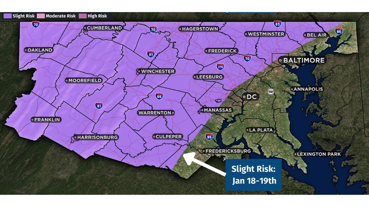
The Climate Prediction Center (CPC) has outlined a Slight Risk for heavy snow across much of the central and western Mid-Atlantic, signaling that conditions may become favorable for impactful snowfall if a developing system tracks correctly. While this does not guarantee a snowstorm, it is an early indicator that winter weather potential is increasing across the region.
What the Slight Risk Area Actually Means
The shaded Slight Risk zone on the CPC outlook covers:
- Western and central Virginia
- Eastern West Virginia
- Parts of western and northern Maryland
- Areas west of Washington, D.C. and Baltimore
A Slight Risk does not imply widespread heavy snow is imminent. Instead, it highlights regions where confidence is increasing that at least some locations could see impactful snowfall, depending on how the storm system evolves over the coming days.
Why This Signal Is Showing Up Now
Medium-range model guidance suggests:
- A large-scale pattern shift toward colder air across the eastern U.S.
- A trough developing over the central and eastern states
- The potential for moisture to interact with colder air as a system moves through the Mid-Atlantic
At this range, models agree on the pattern change, but not yet on storm details such as exact track, strength, or precipitation type.
Why Confidence Remains Limited
Despite the CPC outlook, this setup remains highly conditional:
- Small changes in storm track could mean rain instead of snow, especially east of the Blue Ridge
- Warmer air aloft could limit snow accumulation
- Timing differences between cold air arrival and available moisture are still uncertain
Because of these factors, forecast details will almost certainly change as higher-resolution data becomes available later this week.
What Residents Should Watch Going Forward
For now, this is best viewed as a “heads-up” forecast, not a call to action. Key things to monitor:
- Updated CPC outlooks
- Short-range model trends later this week
- Temperature forecasts leading into the weekend
If the colder pattern locks in and storm timing aligns, localized accumulating snow could become possible, particularly in higher elevations and interior locations.
Bottom Line
This is not a confirmed snowstorm, but it is the first organized winter weather signal of January for the Mid-Atlantic. The presence of a CPC Slight Risk means forecasters are watching closely — and residents should too — as the region heads toward the January 18–19 timeframe.
For continued weather breakdowns, forecast context, and what these patterns actually mean as models update, stay connected with ChicagoMusicGuide.com.