
Virginia’s Central Blue Ridge and Nelson County Under Winter Weather Advisory as 1–3 Inches of Snow Threaten Slick Friday Morning Commute
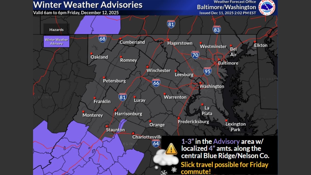
VIRGINIA — Winter Weather Advisory Targets Central Blue Ridge and Nelson County on Friday, A Winter Weather Advisory has been issued for parts of Virginia’s central Blue Ridge and Nelson County as a round of accumulating snow moves in on Friday, December 12, 2025. The advisory, posted by the National Weather Service office in Baltimore/Washington, is valid from 6 a.m. to 6 p.m., covering the heart of the daytime travel period.
Forecasters expect 1–3 inches of snow, with localized totals up to 4 inches along the higher terrain. The timing and intensity of the snow mean drivers could face slick and slushy roads, particularly during the Friday morning commute.
Where the Heaviest Snow Is Expected
The advisory zone highlighted on the map includes:
- Nelson County, Virginia
- Higher elevations along the central Blue Ridge
- Areas near Staunton, Monterey, and the southern Shenandoah Valley just north of the main advisory block
While the most significant totals are focused in the purple-shaded areas, lighter snow is possible outside the advisory:
- Flurries to a dusting of snow may extend along and south of a line from Petersburg, West Virginia, to Fredericksburg, Virginia
- Communities including Harrisonburg, Luray, Warrenton, and the outer suburbs southwest of Washington, D.C. could see brief, lighter bursts
Even minor accumulation in these surrounding locations can still make untreated roads slippery.
Timing: Friday From Early Morning Through Late Afternoon
Snow is expected to begin early Friday morning and continue on and off through the day:
- 6 a.m. – 9 a.m.: Snow develops in the higher elevations of the central Blue Ridge and Nelson County, coinciding with the morning commute.
- Late morning to early afternoon: Steadier snow bands may produce the 1–3 inch totals, with localized heavy pockets in the mountains.
- Late afternoon through early evening: Snow gradually tapers, leaving behind wet and slushy surfaces that can refreeze later at night if temperatures drop.
Because the advisory runs until 6 p.m., both the morning and afternoon drives may be affected.
Impact on Roads, Commuters, and Events
The combination of accumulating snow and daytime traffic could create several hazards:
- Slick highways and secondary roads, especially along I-64, U.S. 29, and smaller mountain routes in Nelson County and the Blue Ridge
- Reduced visibility during heavier bursts of snow
- Slippery sidewalks and parking lots around schools, venues, and businesses
- Longer travel times for commuters heading toward Charlottesville, Staunton, and communities west and southwest of Washington, D.C.
Even where only flurries or a dusting fall from Petersburg, WV, to Fredericksburg, VA, quick coatings on bridges and overpasses may make driving more difficult than conditions first appear.
How Residents Can Prepare
With snow expected during key travel hours, residents are encouraged to:
- Allow extra time for the Friday morning commute
- Use caution on mountain roads and higher elevation passes
- Clear snow from vehicles completely before driving
- Keep an eye on local updates for any changes in snowfall totals or timing
For touring musicians, crews, and fans traveling to or from central Virginia venues, planning for slower travel and potential delays will be important.
Stay Tuned With ChicagoMusicGuide.com
ChicagoMusicGuide.com will continue to track Friday’s winter weather across Virginia and the Mid-Atlantic, watching for any changes in snowfall projections or advisory areas that could affect travel to shows and events.
Check back for more updates as this early-season snow event moves through the region.