
Washington and Oregon Brace for Coldest Night of Winter as Temperatures Plunge Before Weekend Warm-Up
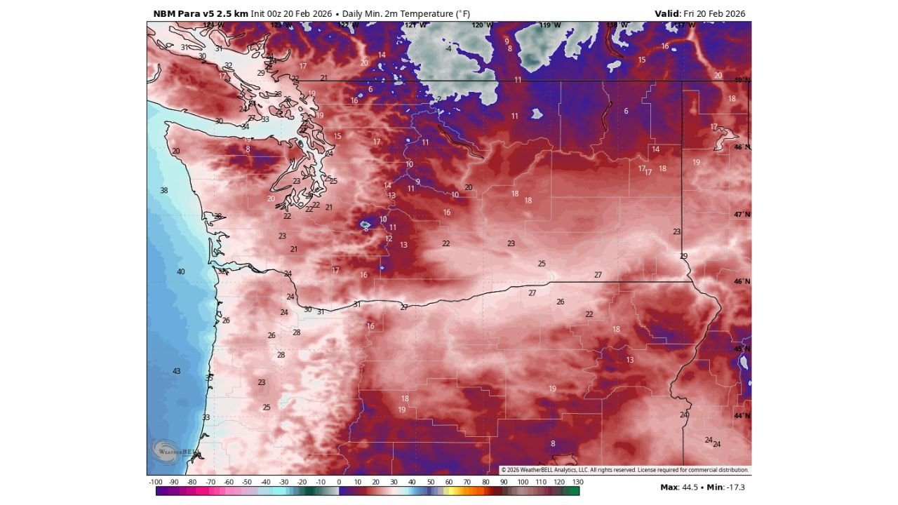
SEATTLE, WASHINGTON — Precipitation has largely come to an end across the Pacific Northwest, but the region is now preparing for what could be the coldest night of the winter season. Forecast data for Friday morning shows widespread sub-freezing temperatures across Washington and Oregon, with interior valleys dropping into the teens and lower 20s.
The cold snap is expected to peak overnight before temperatures begin moderating Friday ahead of another weather system arriving Saturday.
Widespread Teens and 20s Across Washington and Oregon
The temperature forecast map valid for Friday, February 20 highlights a deep pool of cold air settling across the interior Northwest.
Projected overnight lows include:
- Teens across eastern Washington, including areas near Spokane
- Lower teens and single digits in portions of northeastern Washington
- Upper teens to low 20s across central and eastern Oregon
- Low 20s in parts of the Puget Sound region
- Upper 20s along portions of the Oregon Coast
Higher elevations in the Cascade Mountains are expected to be even colder, reinforcing the likelihood that this will be the coldest night of the season for many communities.
Why Tonight Is So Cold
The cold conditions are a result of:
- Clearing skies after recent precipitation
- Dry air allowing efficient nighttime cooling
- Snow cover in some interior areas enhancing radiational cooling
With precipitation ending and winds decreasing, ideal conditions for heat loss overnight have developed. These factors combine to produce sharp temperature drops, especially in valleys.
Communities across Yakima, Wenatchee, Bend, and Spokane could see some of their lowest readings of the winter.
Warmer Air Returns Friday
Despite the frigid start, temperatures are expected to rebound Friday afternoon as a warmer Pacific air mass begins pushing inland.
Highs will climb back above freezing for much of western Washington and western Oregon, marking a noticeable improvement compared to the early morning chill.
This warming trend continues into Saturday as another system approaches the coast.
Snow Levels Jump to 3,500 Feet This Weekend
By Saturday, snow levels are forecast to rise to around 3,500 feet, significantly limiting lowland snow potential.
That means:
- Lowland snow chances appear minimal for the remainder of winter
- Rain will dominate in valleys and coastal communities
- Mountain elevations above 3,500 feet will remain favored for snowfall
For areas like Seattle, Tacoma, Portland, and Eugene, this likely marks a transition toward a more typical late-winter pattern.
Mountains May Benefit From Active Pattern
While low elevations warm, the broader pattern remains supportive of continued precipitation in the mountains.
The Cascade Range in both Washington and Oregon could continue to see periodic snow events, helping build up what has been a relatively low seasonal snowpack in some areas.
Ski resorts and higher-elevation communities may benefit from this setup, even as lower elevations shift toward rain-dominant systems.
What Residents Should Expect
For Friday morning:
- Icy roads possible in untreated areas
- Frost likely widespread
- Cold-sensitive pipes and outdoor plants at risk
By Saturday:
- Milder temperatures
- Increasing cloud cover
- Rising snow levels above lowland communities
As Washington and Oregon endure what appears to be the coldest night of the winter season, attention quickly turns to the incoming weekend system and the shift toward higher snow levels. While lowland snow may be fading for the season, mountain snow opportunities remain on the table. For continued Pacific Northwest weather updates and seasonal outlooks, visit ChicagoMusicGuide.com.