
Western North Carolina Snowfall Event to Favor NC/TN Border With 3 to 6 Inches Possible Through Monday Evening
ASHEVILLE, NORTH CAROLINA — A high-end northwest flow snowfall event is expected to move through Western North Carolina (WNC) beginning Sunday afternoon and continuing through Monday evening. Forecast projections show the heaviest accumulation along the North Carolina–Tennessee border, while lighter snowfall may extend into the Asheville metro area.
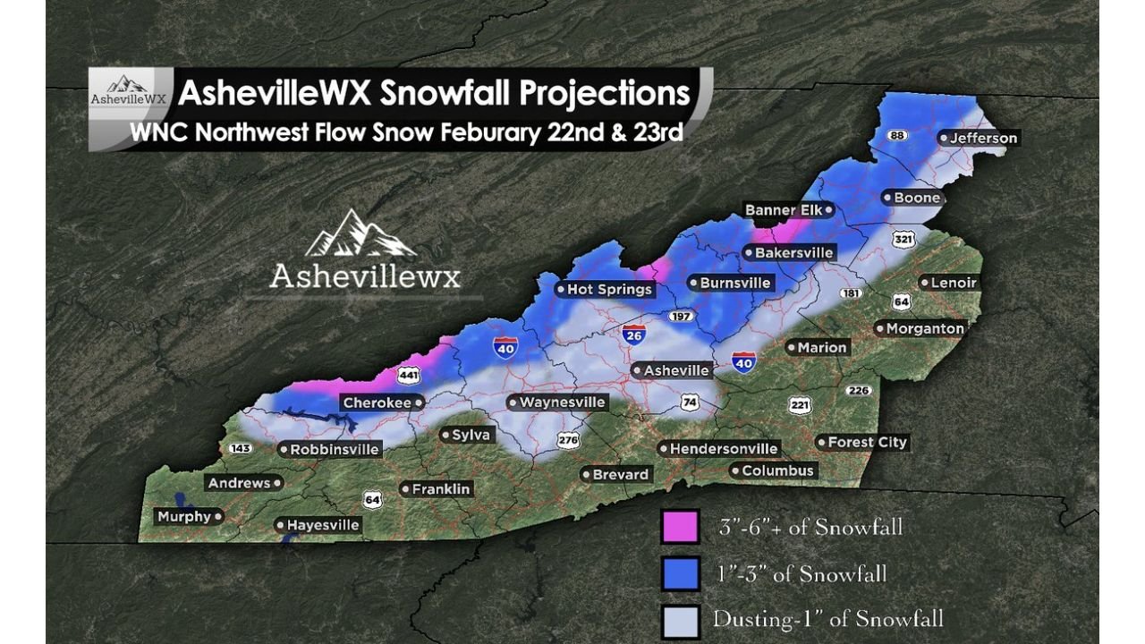
Meteorologists note that this setup favors mountain enhancement, meaning higher elevations near the state line will see the best opportunity for significant snow totals.
3 to 6 Inches Along the NC/TN Border
Snowfall projections indicate 3 to 6 inches of accumulation across elevated areas near the NC/TN border, including communities such as Cherokee, portions of the Smokies along U.S. 441, and higher ridges west of Hot Springs.
These areas sit within the pink-shaded zone on the forecast map, representing the highest snowfall potential in the region. Northwest flow events often maximize totals in terrain-favored locations where cold air is forced upward along the mountains.
Travel through higher elevations could become slick late Sunday into Monday, especially along mountain passes and secondary roads.
1 to 3 Inches Across Northern Mountain Communities
A broader swath of 1 to 3 inches is projected across northern mountain towns including Banner Elk, Bakersville, Burnsville, and areas near Boone and Jefferson.
These communities are positioned within the blue-shaded snowfall zone. While totals may not reach the highest elevations along the immediate border, steady snowfall and colder temperatures could still lead to minor travel disruptions.
Roadways along Interstate 26 near Burnsville and portions of Interstate 40 west of Asheville may experience periods of reduced visibility and accumulating snow.
Dusting to 1 Inch Into Asheville and Surrounding Areas
Further south and east, lighter accumulation is expected. The map indicates a dusting to 1 inch extending into Asheville, Waynesville, and parts of Marion.
Even areas such as Hendersonville, Brevard, and nearby foothill communities could see brief snow showers or light accumulations, though totals are expected to remain limited compared to higher elevations.
Forecasters emphasize that northwest flow events can produce localized variations. Slight changes in wind direction or moisture depth could shift heavier pockets of snow a few miles in either direction.
Event Timing and Impacts
The snowfall is expected to begin Sunday afternoon, intensify at times Sunday night, and taper through Monday evening. The prolonged nature of the event increases the likelihood of gradual accumulation in favored mountain zones.
Residents along the NC/TN border should prepare for:
- Snow-covered mountain roads
- Slick secondary highways
- Reduced visibility in heavier bursts
- Delays in higher elevation communities
While this event does not appear to be a widespread winter storm for all of Western North Carolina, the focused nature of northwest flow snow means certain communities could see meaningful accumulation.
As the system develops across Western North Carolina, officials will continue monitoring snowfall trends and elevation-based impacts. For ongoing weather updates and regional storm coverage affecting cities across the country, visit ChicagoMusicGuide.com.