What Looks Like Widespread Rain Around St. Louis on Radar Is Actually Bugs and Bats With One Real Severe Storm Near Alton
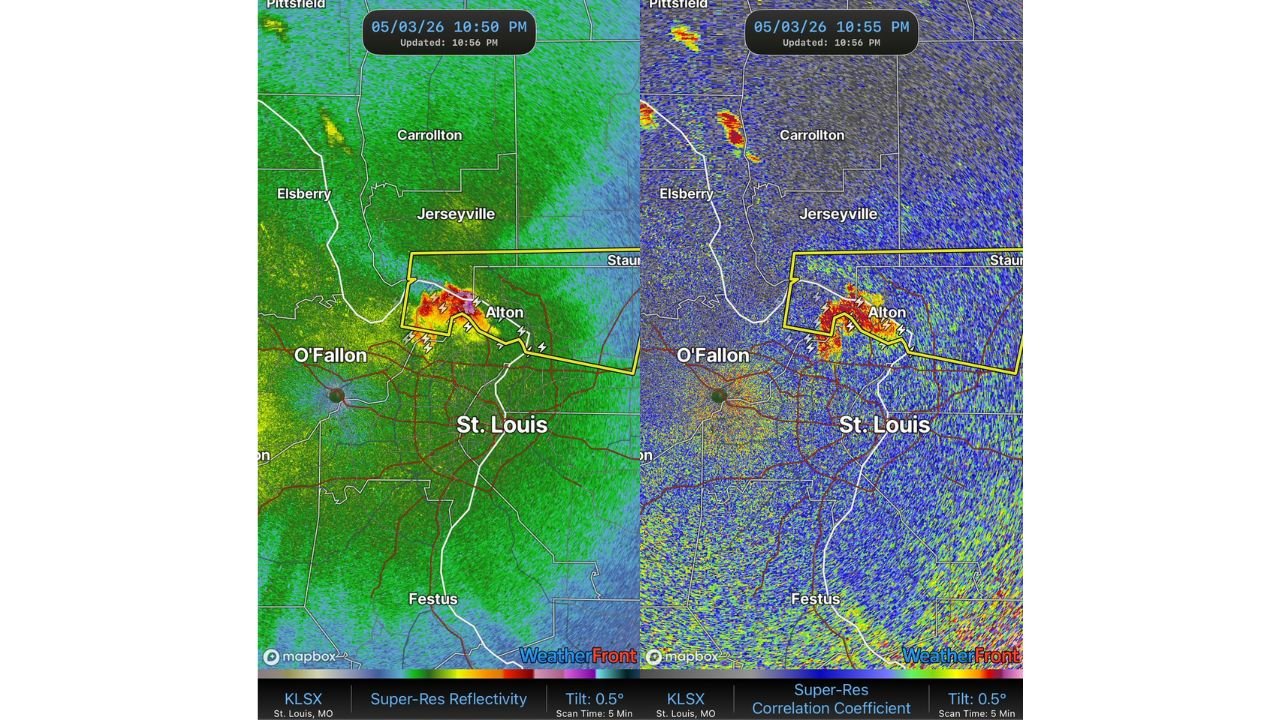
ST. LOUIS, MO — Radar around St. Louis at 10:50 PM on May 3, 2026 looks alarming at first glance. A broad green and yellow mass appears to blanket the entire region. But current dual-polarization radar analysis reveals the truth: the vast majority of what you are seeing is not rain at all. It is bugs and bats.
Reflectivity Is Lying to You Right Now
The standard reflectivity scan shows returns spread across the entire St. Louis metro and surrounding counties. This would normally suggest widespread precipitation. But one look at the Correlation Coefficient scan from the same timestamp at 10:55 PM tells a completely different story.
The Correlation Coefficient — a dual-pol radar product that measures how consistent and uniform the targets in the air are — shows nearly the entire region in deep blue and black, indicating wildly inconsistent, non-uniform targets. That is the signature of insects and bats, not raindrops. Raindrops are relatively uniform in size and distribution, producing high correlation values shown in maroon. Bugs and bats come in all shapes and sizes scattered randomly through the air, producing the chaotic low values seen across most of the St. Louis region right now.
The One Real Storm in the Picture
There is one genuine severe thunderstorm in this radar picture and it is located north of St. Louis near Alton, Illinois. A Severe Thunderstorm Warning is active for this cell. The storm shows a tight core of high reflectivity values in red and purple on the reflectivity scan, and critically, the Correlation Coefficient scan shows a maroon high-CC core at the exact same location. That confirms real precipitation, real lightning, and a real severe thunderstorm worthy of the warning.
Everyone else in the broader St. Louis metro area seeing green on radar tonight is looking at nature, not a storm.
How to Read This on Your Weather App
| What You See | Correlation Coefficient | What It Actually Is |
|---|---|---|
| Green/yellow spread across metro | Blue and black (low CC) | Bugs and bats, not rain |
| Tight red/purple core near Alton | Maroon (high CC) | Real severe thunderstorm |
The Takeaway for Tonight
St. Louis metro residents do not need to be concerned about widespread rain tonight. The only active threat is the severe thunderstorm near Alton on the Illinois side. Always check dual-pol products alongside basic reflectivity before reacting to what radar appears to show.
More weather coverage is always on the horizon. Stay informed at ChicagoMusicGuide.com — your source for radar education, storm tracking, and breaking weather coverage across Missouri, Illinois, and the entire United States.