
Widespread Warm-Up Expected as Illinois, Indiana, and Much of the Midwest Shift Toward Unseasonably Mild December Weather
ILLINOIS — A Major Shift From Winter Chill to Unseasonably Warm December Air, A dramatic warm pattern is expected to develop across Illinois, Indiana, and much of the central United States next week, signaling a sharp break from the early-season winter conditions many areas have recently experienced. Based on broad atmospheric guidance, a significant warm air mass is forecast to expand across the central and eastern U.S., delivering temperatures far above average for mid-December.
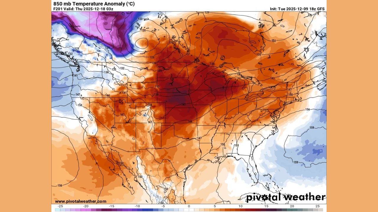
The developing pattern suggests that large portions of the Midwest could feel conditions more typical of early fall than the week before Christmas. The temperature anomaly projection shows unusually warm air centered over Illinois, Indiana, Iowa, Missouri, Wisconsin, and Michigan, with mild conditions spreading outward across the Plains and Southeast.
A Broad Warm Surge Covering the Heart of the Nation
Imagery shows widespread positive temperature anomalies at mid-levels of the atmosphere, an indication of strong regional warming. Much of the Midwest is depicted in deep orange and red shading — a clear signal that the incoming temperatures will run well above climatological norms for this time of year.
Key regions affected include:
- Illinois and Indiana
Expected to experience some of the strongest warm departures next week. Wind flow patterns will help pull mild central U.S. air directly into the region. - Iowa, Wisconsin, Michigan, and Missouri
Forecast to see a similar spike in temperatures, with several degrees above seasonal averages likely. - The Central and Northern Plains
States such as Nebraska, Kansas, and the Dakotas will also feel the rapid warm-up spreading outward from the Midwest core. - The Ohio Valley and Mid-Atlantic
Warmer-than-normal readings are projected to extend eastward into Ohio, Kentucky, Pennsylvania, and beyond.
While cold air lingers over parts of the Pacific Northwest and far northern Rockies, the dominant national pattern favors widespread mild conditions across central and eastern regions.
What This Means for Residents
For Illinois and surrounding states, the warm shift will likely produce:
- Afternoon highs several degrees above normal
- A noticeable break from early-winter chill and recent cold waves
- Potentially wet rather than snowy conditions for some areas
- A temporary pause in winter-like weather as late December approaches
This warm spell arrives during a period when many residents typically prepare for more persistent cold, making the upcoming pattern a noteworthy departure from seasonable expectations.
Looking Ahead: How Long Will the Warmth Last?
While the warm-up appears solidly in place for next week, it is still unclear how long it will dominate the central U.S. pattern. Large temperature swings are common in December, and substantial cold air remains present across Canada and the northern tier.
However, for now, Illinois, Indiana, and much of the Midwest can expect a significant — and possibly short-lived — break from winter conditions.
Stay Ready for More Weather Updates
As temperatures fluctuate in the weeks leading into the holidays, ChicagoMusicGuide.com will continue tracking major pattern shifts, warm surges, or renewed winter threats affecting Midwest residents and traveling music fans.
For ongoing updates, stay connected right here with ChicagoMusicGuide.com.