
Winter Storm Bellamy to Bring 8–12 Inches of Snow and Possible Thundersnow Across Iowa, Missouri, and Western Illinois Tonight
CHICAGO – A Powerful Winter Storm Expected to Intensify Overnight With Heavy Snow and Rare Thundersnow Potential, A rapidly strengthening winter storm — identified as Winter Storm Bellamy — is expected to push across the Midwest late Friday night into Saturday morning, bringing a dangerous mix of heavy snow, intense snow bands, and the potential for thundersnow across several states. Updated model guidance highlights a zone of strong instability capable of producing lightning and thunder embedded within heavy snowfall, particularly across Northern Missouri, central and southern Iowa, and parts of Western Illinois.
The system will continue moving east through Saturday, affecting travel, weekend events, and early-morning performances across the region.
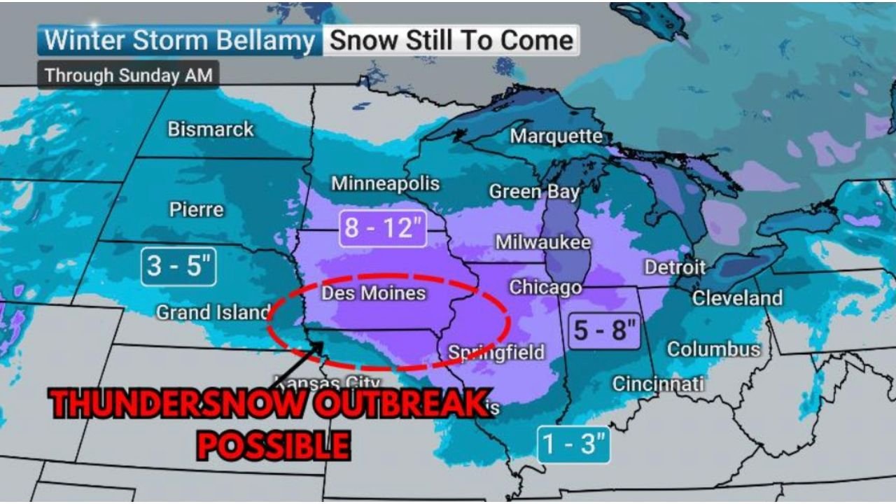
8–12 Inches of Snow Forecast for Central Iowa and Surrounding Areas
Forecast maps show a core region of 8–12 inches of snowfall, centered over:
- Des Moines and central Iowa
- Parts of northern Missouri
- Western Illinois
This corridor sits beneath the storm’s strongest deformation band — a zone where moisture and lift overlap to create long-lasting, heavy snowfall.
Areas across Wisconsin, Northern Illinois (including Chicago), and into Michigan are expected to receive 5–8 inches, consistent with earlier predictions.
Thundersnow Outbreak Possible in Iowa, Missouri, and Western Illinois
The model highlights a red-circled zone from Kansas City through Des Moines and into Western Illinois, where atmospheric instability appears sufficient to produce widespread thundersnow.
Thundersnow is a rare cold-season phenomenon characterized by:
- Lightning and thunder within heavy snow bands
- Extremely fast accumulation rates
- Brief periods of near-whiteout visibility
- Dangerous travel conditions
Meteorologists note that the “supercharged airmass” behind this storm could generate intense snowfall rates that exceed 2 inches per hour in localized areas.
Snowfall Totals Across the Upper Midwest
According to updated projections:
- 8–12 inches → Central Iowa, parts of Northern Missouri, Western Illinois
- 5–8 inches → Chicago region, Milwaukee, Springfield, Detroit
- 3–5 inches → Nebraska, parts of Minnesota, the Dakotas
- 1–3 inches → Far southern areas near the Ohio Valley
Chicago remains within the 5–8 inch zone, with heavier totals possible if the main snow band shifts slightly north.
Impacts for Musicians, Events, and Travel Plans
Winter Storm Bellamy is arriving during a busy weekend for performers, holiday shows, and indoor venues. The combination of heavy snow and thundersnow may cause:
- Hazardous travel for late-night gigs or Saturday morning performances
- Slower venue setups due to poor road and parking conditions
- Potential last-minute schedule changes for regional events
- Reduced attendance at live shows due to visibility concerns
- Delays for musicians traveling from Iowa, Missouri, or Illinois into Chicago
Artists traveling overnight should prepare for rapidly worsening conditions along major corridors including I-35, I-80, and I-74.
A High-Impact Storm That Requires Close Monitoring
As the surface low moves east through Saturday morning, snowfall rates, embedded storms, and shifting bands may change conditions quickly. Communities across the Midwest should stay alert to real-time updates as the storm evolves.
Are you adjusting weekend performance plans because of Winter Storm Bellamy? Share your updates with us at ChicagoMusicGuide.com — we’re following conditions closely and want to hear from musicians across the region.