Arkansas Atmosphere Recovers as Fresh Severe Storms From Oklahoma and Texas Move In Bringing Extremely Large Hail and Tornado Threat Through Tuesday Evening
LITTLE ROCK, AR — The first round of severe weather is moving out of Arkansas — but the state is far from done. Current radar analysis captured at 3:07 PM CDT Tuesday, April 28, 2026 confirms that while late morning and early afternoon storms are pushing east out of the state, the atmosphere across central, southern, and western Arkansas has recovered significantly. Numerous significant severe thunderstorms are now tracking eastward out of Oklahoma and Texas directly toward a reloaded and fully fueled Arkansas environment. The evening hours carry a real and ongoing threat of extremely large hail and a few tornadoes before the severe weather pattern finally breaks.
Arkansas is not getting a break yet. The worst of the evening round may still be ahead.
What Radar Is Showing Right Now
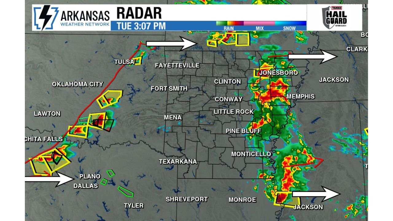
Live radar at 3:07 PM CDT shows a two-pronged severe weather situation unfolding simultaneously across the region. To the west, a line of severe-warned storms — marked with multiple yellow severe thunderstorm warning boxes — is tracking eastward out of Oklahoma near the Tulsa, Lawton, and Wichita Falls corridor. The white arrows on current radar indicate storm motion pushing rapidly east-northeast toward the Arkansas border. These storms are carrying the hail and tornado potential that has already been well-documented in the afternoon analysis across north Texas and Oklahoma.
To the east, a separate cluster of intense storm activity is shown near Jonesboro, Memphis, and the Monticello area — storms that have already pushed across Arkansas and are now exiting into Tennessee and Mississippi. A tornado warning polygon in red is visible near the Jonesboro-Memphis corridor, indicating active tornado-warned activity still in progress on the eastern fringe of the state.
The center of Arkansas — from Fort Smith through Little Rock, Conway, Pine Bluff, and Texarkana — is currently in a relative lull between these two storm clusters. That lull is the atmospheric recovery window. And the recovery, according to current analysis, has been substantial across the central and southern portions of the state.
The Recovery That Makes This Evening Dangerous
The critical forecasting development driving Tuesday evening’s continued threat is the atmospheric recovery across central and southern Arkansas. When the morning and early afternoon storm cluster pushed through, it temporarily stabilized the boundary layer — cooling the surface, reducing instability, and limiting the fuel available for new storm development. That stabilization is now reversing.
Current analysis confirms that the atmosphere across the west half and central and southern Arkansas has recovered meaningfully through the early afternoon hours. Surface heating has resumed, moisture has remained rich, and the instability that made this morning’s storms dangerous is being rebuilt in time for the incoming storm cluster from Oklahoma and Texas to exploit it. This is the exact scenario that produces the most dangerous evening severe weather events — a recovered environment waiting for organized storms to arrive from upstream.
With an abundance of storm fuel now back in place, the incoming severe storms from Oklahoma and Texas will have access to a fully reloaded atmosphere when they cross into Arkansas during the late afternoon and evening hours.
Threats for the Remainder of Tuesday
Extremely large hail is the headline threat for the evening round across Arkansas. The storm clusters approaching from the west have already been producing significant hail across Oklahoma and north Texas, and the recovered instability environment in Arkansas will do nothing to weaken those hail cores as storms move in. Golf ball to baseball-sized hail remains possible with the most intense storm cores.
Tornadoes are also possible during the evening hours, particularly with any discrete supercell development ahead of the main storm line. The atmospheric wind shear profile across Arkansas this evening remains supportive of rotating updrafts, and any storm that can stay discrete in the recovered warm sector environment will have tornado potential.
Current Storm Positions and Motion
| Storm Cluster | Current Location | Motion | Target Zone |
|---|---|---|---|
| Western cluster (active warnings) | Oklahoma / Wichita Falls TX | East-northeast | Western Arkansas by late afternoon |
| Northern exiting storms | Jonesboro / Memphis fringe | East | Tennessee, Mississippi |
| Southern exiting cluster | Jackson MS / Monroe LA fringe | East-southeast | Exiting region |
| Recovery zone (no storms, reloading) | Fort Smith to Little Rock to Pine Bluff | Stationary | Incoming storm fuel zone |
Community Impact Outlook
Fort Smith and western Arkansas — First in line for the incoming storm cluster from Oklahoma. Severe weather including large hail and possible tornadoes expected during the late afternoon hours. Residents should be weather-alert and sheltered before storms arrive.
Little Rock, Conway and central Arkansas — Within the recovered instability corridor. As storms push east from Fort Smith, this corridor becomes the primary impact zone during the evening hours. The combination of recovered atmosphere and incoming organized storm cluster makes this a high-priority monitoring zone.
Pine Bluff, Monticello and south-central Arkansas — Southern portion of the recovered atmosphere. Storms tracking southeast out of Oklahoma and Texas may impact this area as well. Large hail and tornadoes remain possible.
Texarkana and southwest Arkansas — On the southern track of the incoming storm system. Evening severe weather timing is expected for this corridor as storms push east from north Texas.
Jonesboro and northeast Arkansas — Currently seeing exiting storm activity with active tornado warnings in the area. Residents should remain sheltered until the eastward-moving cluster fully clears the region.
Forecast Confidence
Confidence in continued significant severe weather across Arkansas through Tuesday evening is HIGH. The atmospheric recovery is confirmed by current analysis. The incoming storm cluster from Oklahoma and Texas is well-defined on radar and tracking directly toward the reloaded environment. Confidence in extremely large hail with the evening storm round is HIGH. Confidence in tornado potential for discrete supercells ahead of the main line is MODERATE to HIGH across central and western Arkansas.
The break is coming — but it is not here yet. Stay weather-aware across Arkansas through the evening hours and keep warnings active on every device.
More severe weather coverage is always on the horizon. Stay informed at ChicagoMusicGuide.com — your source for live storm tracking, evening severe weather updates, and breaking tornado and hail coverage across Arkansas and the entire United States.