Alabama Snow Chances Fade as Forecast Models Push Back Against Viral Winter Storm Claims
ALABAMA — Once again at the center of online winter weather speculation, but updated forecast data suggests that viral snowstorm claims circulating across social media are not supported by the most reliable weather models. While cold air will move into the Deep South this week and again over the weekend, confidence remains high that snow accumulation and meaningful impacts across Alabama are unlikely.
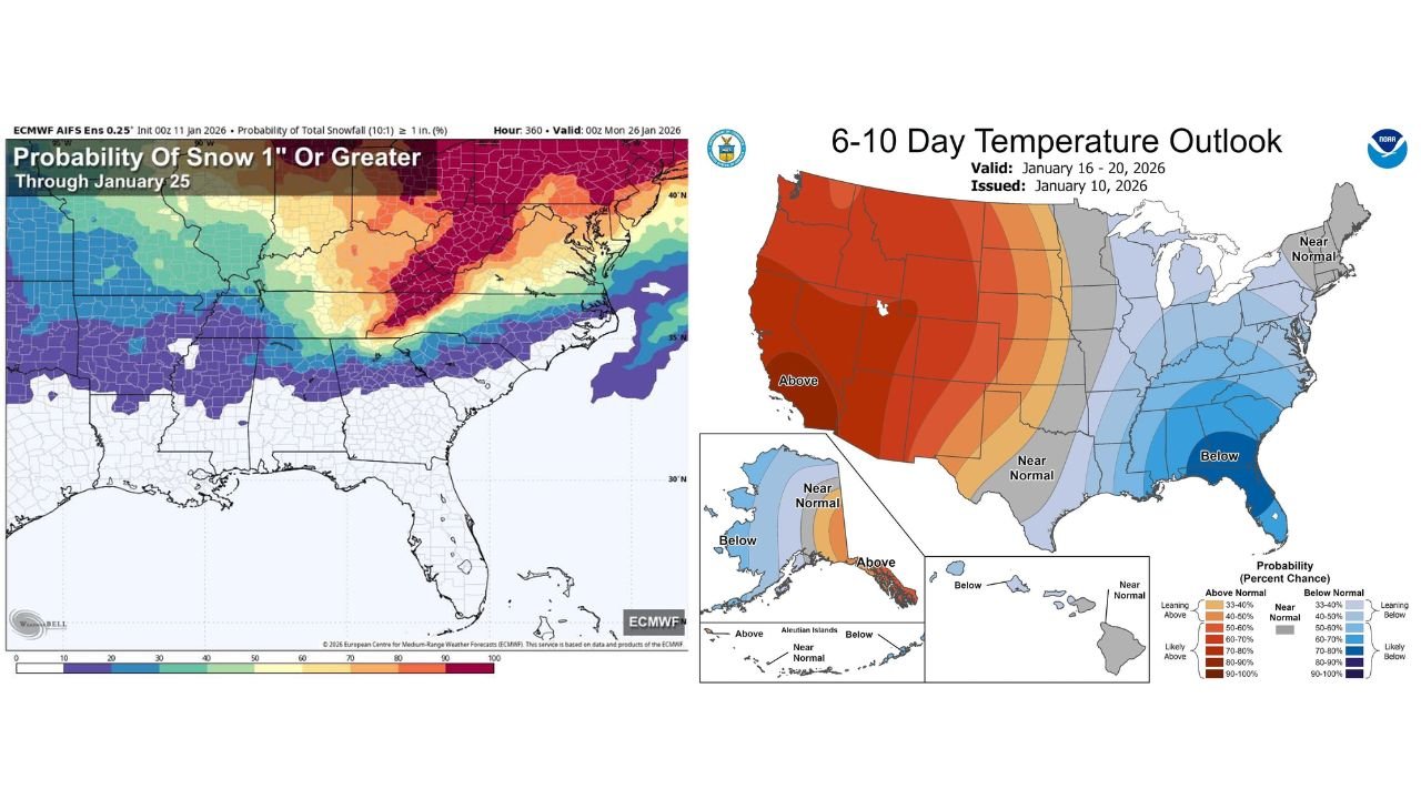
Forecast guidance from long-range ensemble models shows that while temperatures will trend sharply colder, moisture, timing, and atmospheric alignment are not favorable for accumulating snow across most of the state.
Cold Air Is Coming, But Snow Setup Remains Weak
A very cold air mass is expected to drop southward into North Alabama late Wednesday night into Thursday morning, followed by another reinforcing push of Arctic air this weekend. Despite the colder temperatures, forecasters emphasize that cold alone does not guarantee snow.
The mid-week system may produce a few isolated flurries, particularly across far northern Alabama, as cold air briefly overlaps with limited moisture. However, confidence remains high that no accumulation or travel impact will occur, with ground temperatures too warm and moisture too shallow to support snowfall.
A similar pattern is expected this weekend as another Arctic front moves through Sunday. While colder air will follow the front, model guidance shows mainly scattered light rain with the frontal passage, with only a low chance of flurries afterward. As with the mid-week system, no accumulation is expected.
Why Viral Snow Maps Are Misleading Right Now
Much of the online snow hype stems from deterministic model runs, particularly from the American GFS, which has periodically suggested accumulating snow in parts of Alabama on individual runs. However, forecasters caution that single-run outputs are not forecasts.
More reliable guidance comes from ensemble modeling, which runs dozens of simulations with small variations to capture uncertainty. The ECMWF ensemble, widely considered the most reliable global winter model, currently shows declining probabilities for even one inch of snow across North Alabama over the next 10 to 15 days.
Ensemble output highlights a wide range of outcomes, most of which produce no snow at all. This spread reinforces the conclusion that confidence in a snow event is low, especially at this lead time.
Understanding the Forecast Challenge
Winter forecasting in the Deep South is especially difficult due to shallow cold layers, boundary-layer temperature issues, and rapid phase changes between rain and snow. Small errors in timing or moisture depth can completely change outcomes.
The current pattern lacks the necessary ingredients for snow accumulation:
- Insufficient moisture depth
- Poor overlap between cold air and precipitation
- Warm ground temperatures
- Short-lived forcing
While the atmosphere may briefly support snowflakes in the air, surface conditions strongly favor rain or virga, not forcing accumulation.
Coldest Air of the Season Still Expected
Although snow is unlikely, the cold itself is very real. Forecast trends point to the coldest air of the season arriving around Sunday, with temperatures dropping well below normal across Alabama and much of the Southeast.
This cold outbreak may bring hard freezes, especially across northern and central portions of the state, with overnight lows potentially dipping into the 20s. Residents should prepare for cold-sensitive impacts, such as frozen pipes, livestock concerns, and increased heating demand.
Importantly, this cold outbreak does not appear to be tied to a winter storm capable of producing snow or ice accumulation.
Forecast Confidence and What Comes Next
The weekend system remains several days away, and forecasts can still evolve. However, current confidence strongly favors a cold but quiet weather pattern rather than a winter storm.
Forecasters stress that panic is not warranted, and that snow maps circulating online should be treated with caution until the forecast window narrows further. Within three days of a potential event, forecast confidence improves significantly — and at this time, signals remain weak.
As Alabama moves into a colder stretch of January weather, staying informed with accurate, model-based updates matters more than reacting to viral speculation. For continued weather coverage, forecast breakdowns, and clear explanations as conditions evolve, follow ChicagoMusicGuide.com for reliable updates throughout the week.