Florida, Georgia, Kentucky, Illinois, Indiana and Michigan Could Turn Much Snowier as Late-January Pattern Flips
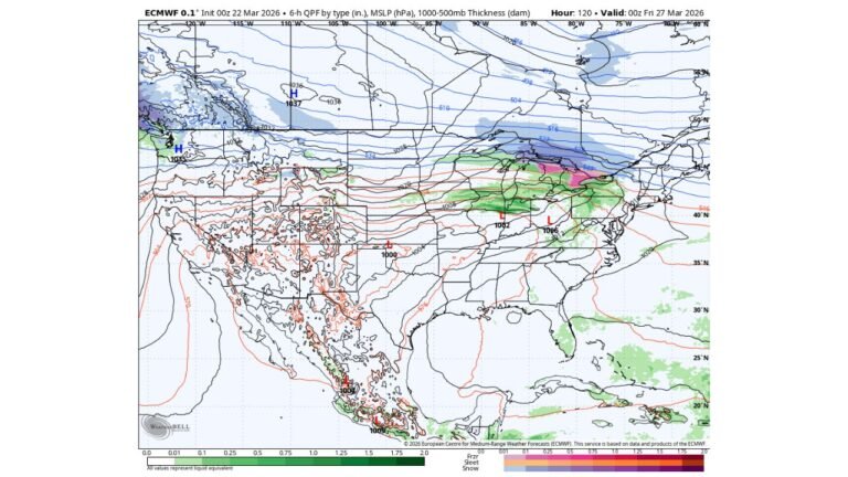
UNITED STATES — A new long-range setup is increasingly pointing toward a colder and snowier stretch from late January into early February, with the jet stream pattern favoring repeated shots of Arctic air across the eastern half of the country and a more active storm track than what much of early 2026 has delivered so far.
Forecast discussion tied to European ensemble guidance suggests snow potential expanding unusually far south, while the Great Lakes and Northeast sit in the zone with the strongest signal for multiple meaningful snow events if the storm track verifies.
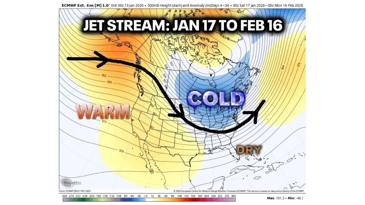
What the pattern is signaling (late January into mid-February)
A month-ahead jet stream outlook (roughly Jan. 17 through Feb. 16) is being described as one that strongly favors big cold air intrusions in the eastern U.S. That kind of setup matters because when cold air is in place, even modest moisture can turn into snow or mixed precipitation—especially near the typical battle line from the South into the Mid-Atlantic.
The same outlook also leans toward an uptick in storm activity late January and especially early February, after a relatively quiet start to the winter season for large, widespread snowstorms in many eastern markets.
How far south snow could reach: Florida Panhandle and North Georgia on the map
One of the biggest attention-grabbers in the current guidance is the southern edge of the snow risk.
- North Georgia is showing signals of over 1 inch of snow in long-range ensemble output.
- There are also hints of flurries as far south as the Florida Panhandle, which is unusual enough that it’s being highlighted in the forecast discussion.
That does not guarantee a “Florida snow event,” but it does raise the odds that at least one system could push wintry weather farther south than normal—especially if cold air arrives first and moisture rides along the Gulf/Atlantic side afterward.
Kentucky and the interior South: a clearer snow signal than usual
Compared with the deep South, guidance is showing a more defined snow potential across parts of the interior:
- A “solid signal” is being discussed for at least 4–6 inches in Kentucky during the broader window.
Kentucky often sits in a prime corridor when cold air bleeds south and storms track from Texas or the Gulf toward the Appalachians or Mid-Atlantic. If the storm track becomes more active, Kentucky can end up in the swath where snow totals add up quickly across multiple events.
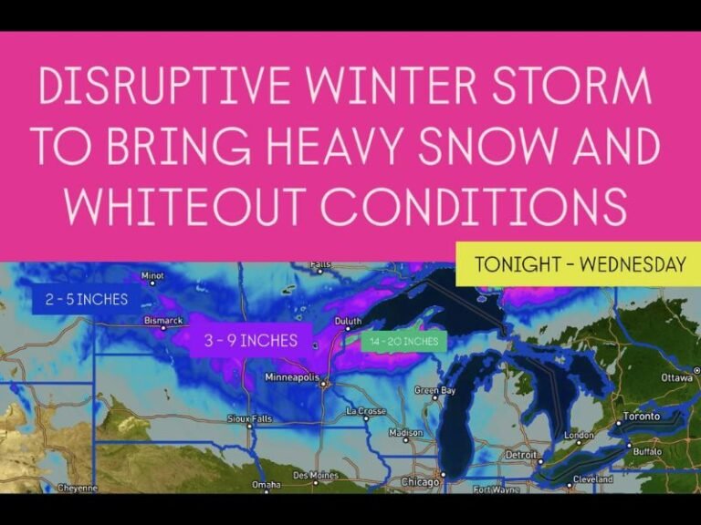
Illinois, Indiana, Michigan and the Great Lakes: where totals can stack fast
The strongest “big snow” language in the outlook is focused from the Great Lakes into the Northeast, with a very large area showing the potential for double-digit snow totals over time.
For the Great Lakes region—Illinois, Indiana, Michigan, Wisconsin, and Ohio—that typically means two main snow routes:
- Storm-track snow from passing low-pressure systems that spread a broad shield of snow
- Lake-effect snow that can explode when Arctic air crosses the warmer lake waters (especially in snow belts)
If the pattern turns more active, Chicago and northern Illinois can still see snow, but the most extreme “stacking” often occurs downwind of the lakes—where localized totals can climb far faster than surrounding areas.
Northeast states in the crosshairs: Pennsylvania to New Jersey and beyond
On the long-range snow map, the corridor from the Great Lakes into the Northeast is being framed as a zone that could see 10/20/30 inches over time—not necessarily in one storm, but through repeated events.
That kind of language usually points toward a storm track that frequently reloads along the eastern U.S., pulling moisture into cold air and producing multiple snow opportunities for states like:
- Pennsylvania
- New York
- New Jersey
- and nearby parts of New England
The exact placement of the heaviest snow axis can still shift north or south by a state or two depending on how each individual storm tracks.
Why confidence is still limited right now
Even with strong-looking long-range signals, the same discussion acknowledges a key uncertainty: where moisture sets up.
In practical terms, that means the difference between:
- a cold, dry miss, or
- a plowable snow, or
- a messy mix of sleet/freezing rain near the rain/snow line
As the calendar gets closer, higher-resolution models typically sharpen the forecast and reveal whether the pattern produces one dominant storm or several smaller-but-impactful systems.
Severe weather outlook: quieter than normal for now
While the snow/cold signal is rising, the outlook suggests the overall pattern is not especially favorable for widespread severe weather over the next few weeks. The exception noted is that a system or two near the Gulf Coast or Florida could still produce some storms, but the “bigger picture” severe threat may hold off until later in February as broader climate influences shift.
Florida-specific note: colder shots and a drier trend
For Florida, the pattern is described as drier than average, with a higher chance for repeated Arctic fronts and bigger temperature swings. A drier setup can also worsen drought concerns, even while cold fronts keep arriving.
What this could mean for travel, shows, and weekend plans
Because this outlook covers multiple states and a multi-week window, the most important takeaway for travelers and concertgoers is planning flexibility:
- Expect more last-minute schedule changes if storms start lining up along the Great Lakes-to-Northeast corridor.
- If you’re driving for shows, watch for rapidly changing road conditions near lake-effect zones.
- For flights, the biggest ripple effects often come from storms impacting major hubs across the Midwest and Northeast.
If this pattern locks in, it’s the kind that can turn “ordinary winter weather” into repeated disruptions—especially once we get into the late-January and early-February storm window.
If you’re in Florida, Georgia, Kentucky, Illinois, Indiana, Michigan, Pennsylvania, New York, or New Jersey, what are you seeing in your local forecasts so far—do you think this turns into the first truly active stretch of the 2026 winter? Share what you’re noticing and keep the conversation going at ChicagoMusicGuide.com.