New England, Upstate New York, and Interior Northeast Plunge Below Zero as Arctic Air Delivers a Brutally Frigid Night
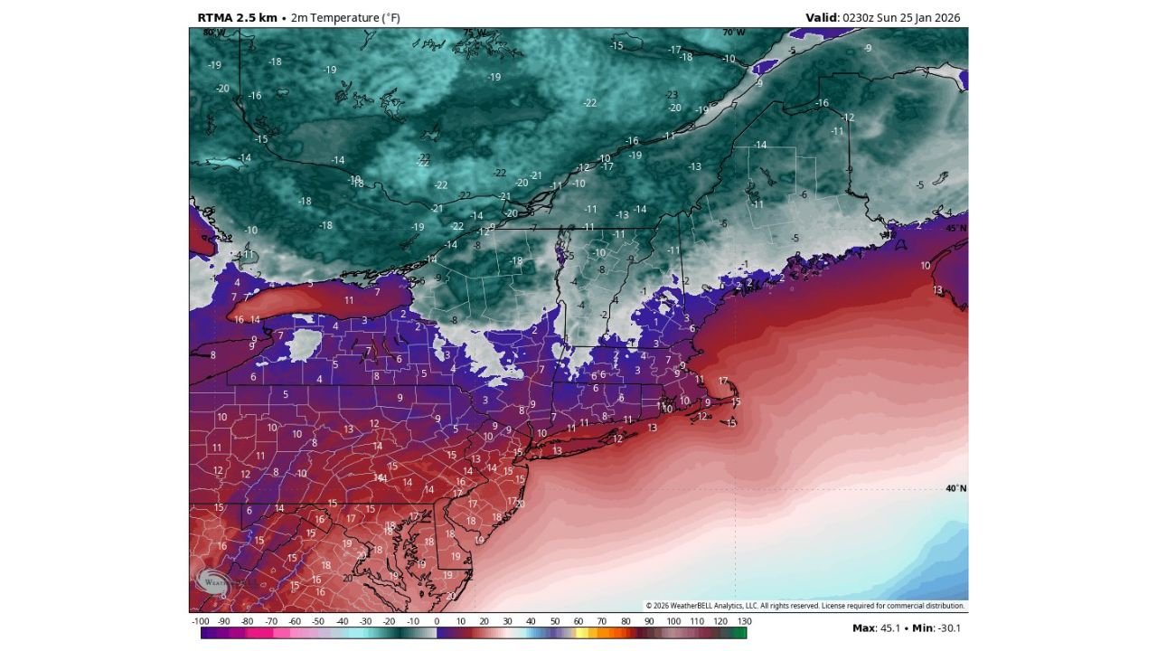
UNITED STATES — A dangerously cold Arctic night is unfolding across the Northeast, with temperatures already below zero in many inland locations as lighter winds allow the cold air to fully settle in. Real-time temperature analysis late Saturday night shows widespread subzero readings across interior New England and upstate New York, while coastal areas and the Mid-Atlantic hover in the teens — still well below seasonal norms.
Meteorologists warn this setup favors maximum radiational cooling, meaning temperatures may continue to fall through the overnight hours, especially away from the coast.
Subzero Temperatures Dominate Interior New England and Upstate New York
The coldest air is firmly entrenched across northern and interior sections of New York, Vermont, New Hampshire, and Maine, where temperatures have already dropped into the single digits below zero, with some pockets nearing -20°F to -25°F.
Large areas north of the Massachusetts Turnpike and across northern New England are locked beneath deep Arctic air, with readings well below freezing even before midnight. Snow cover from recent storms is enhancing the cold by reflecting heat away from the surface.
Coastal Northeast and Mid-Atlantic Still Bitterly Cold
While the immediate coastline is avoiding the worst of the subzero air, conditions remain harsh. Much of Massachusetts, Rhode Island, Connecticut, Long Island, New Jersey, eastern Pennsylvania, and coastal New England are sitting in the single digits to mid-teens.
Farther south across Maryland, Delaware, and southern New Jersey, temperatures range from the mid-teens to near 20°F, but lighter winds mean the cold feels sharper and more penetrating than typical winter nights.
Why This Night Is Especially Dangerous
This cold event is notable not just for the temperatures, but for the calm wind conditions accompanying it. With lighter winds:
- Heat escapes rapidly from the ground
- Temperatures fall faster overnight
- Frostbite risk increases during prolonged exposure
- Pipes and infrastructure freeze more easily
In many inland areas, wind chills are only marginally warmer than actual air temperatures, offering little relief for anyone outdoors overnight.
What Happens Through Early Sunday Morning
Temperatures are expected to bottom out just before sunrise, particularly across interior New England and upstate New York. Some locations may briefly touch their coldest readings of the season so far before a slow and limited warm-up begins Sunday.
Despite sunshine returning later in the day, temperatures will struggle to rebound, keeping much of the Northeast locked in below-freezing conditions through Sunday afternoon.
Safety Concerns as Cold Lingers
Officials urge residents to:
- Limit time outdoors overnight
- Dress in multiple insulating layers
- Protect pets and livestock
- Allow faucets to drip to prevent frozen pipes
- Check on vulnerable neighbors
The Arctic air mass responsible for this cold is slow to retreat, meaning frigid conditions will persist across the Northeast into early next week, even as the major winter storm exits the region.
For continued coverage of extreme cold, winter storm impacts, and regional weather trends across the United States, stay with ChicagoMusicGuide.com.