Eastern U.S. Faces a Sneaky but Dangerous Winter Hit as Narrow Snow Bands and Brutal Arctic Cold Target New England, New York, and the Mid-Atlantic
UNITED STATES — The first full weekend of February is shaping up to be one of the most deceptive and dangerous winter stretches of the 2025–26 season, as a weak-looking system combines with extreme Arctic air to produce localized heavy snow, plummeting temperatures, and life-threatening wind chills across the eastern half of the country.
While many areas will see only light snowfall, a few very narrow but intense snow bands could dramatically change conditions for select communities, especially from Upstate New York through Long Island and into New England. At the same time, a powerful Arctic front will crash south, ushering in the coldest air of the season for much of the Mid-Atlantic and Northeast.
Narrow Snow Bands Could Create Big Local Impacts
Forecast data shows this will not be a widespread blockbuster snowstorm, but rather a precision-driven event where placement matters everything.
- Most areas: 1–3 inches
- Western & Central New York / parts of New England: 3–6 inches
- Isolated “lucky” zones in Eastern Massachusetts & coastal New England: 5–8 inches possible
These heavier totals depend entirely on whether a town gets caught under one of the narrow snow bands that develop as the system moves offshore. Communities just a few miles apart could see vastly different outcomes.
Eastern Massachusetts currently has the highest odds of seeing one of these bands set up, though confidence in exact placement remains low.
Upstate New York and Long Island Remain Prime Targets
Model guidance continues to highlight:
- Upstate New York: Potential for accumulating, plowable snow with locally higher totals
- Long Island & NYC metro: Light to moderate accumulations possible, especially near the coast
- New Jersey Shore: Increasing signal for accumulating snow if bands shift slightly south
High snow-to-liquid ratios mean it won’t take much moisture to pile up totals quickly.
Arctic Front Brings the Coldest Air of the Season
Behind the snow comes the real story — an intense Arctic blast, possibly the strongest of the winter so far.
- Temperatures: Dropping into the teens and single digits by Saturday morning
- Wind gusts: 45–55 mph, especially overnight Friday into Saturday
- Wind chills:
- East of the Blue Ridge: 0 to -10°F
- West of the Blue Ridge & higher terrain: -20 to -30°F
Extreme Cold Watches and Warnings are already in effect across large portions of the Mid-Atlantic and Northeast, with upgrades expected as confidence increases.
Friday Night Through Saturday: The Most Dangerous Window
The most hazardous stretch appears to be Friday night into Saturday morning, when snow, wind, and rapidly falling temperatures overlap.
Snow will be blown and drifted, visibility may drop suddenly in squalls, and exposed skin could develop frostbite in minutes. Power outages are possible in mountain areas due to wind gusts exceeding 50 mph.
This will likely rank as the harshest 24-hour winter period so far this season for many communities.
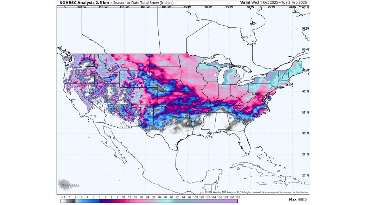
A Tale of Two Winters Across the U.S.
Season-to-date snowfall maps highlight a striking contrast:
- Eastern U.S.: Widespread above-average snowfall
- Western U.S.: Many mountain regions well below normal, with some areas seeing less than 60 inches where 200–300 inches are typical
This imbalance raises concerns heading into summer, with enhanced drought and wildfire risk expected across parts of the West in 2026.
What to Watch Next
Forecasters stress that pinpointing exact snow band placement remains the biggest challenge, and even small shifts could change local totals significantly. Another potential winter system may follow later next week, potentially ending the recent dry stretch for parts of the East.
Bottom Line
This weekend isn’t about how much snow everyone gets — it’s about who gets hit, when, and how cold it becomes afterward. For some, it will feel like a full-fledged winter storm. For others, a reminder of how unforgiving Arctic air can be when paired with wind. Stay weather-aware, limit exposure during peak cold, and keep an eye on updated forecasts as details sharpen. For ongoing winter weather updates, regional breakdowns, and how upcoming conditions could impact events and travel, follow along at ChicagoMusicGuide.com.