Mid-Atlantic Snowstorm Uncertainty Grows as Ensembles Signal Low-Probability but High-Impact Threat for Sunday–Monday
MID-ATLANTIC — While recent model runs no longer show a guaranteed major snowstorm for Sunday into Monday, new ensemble probability data reveals a more complicated picture across the Mid-Atlantic, including parts of Pennsylvania, New Jersey, Delaware, Maryland, and southern New York.
Most ensemble members do not show significant snowfall. However, among the members that do generate snow, many indicate a major snowstorm scenario — creating what meteorologists call a “low-likelihood, high-impact” setup.
Probability Maps Show Mixed Signals
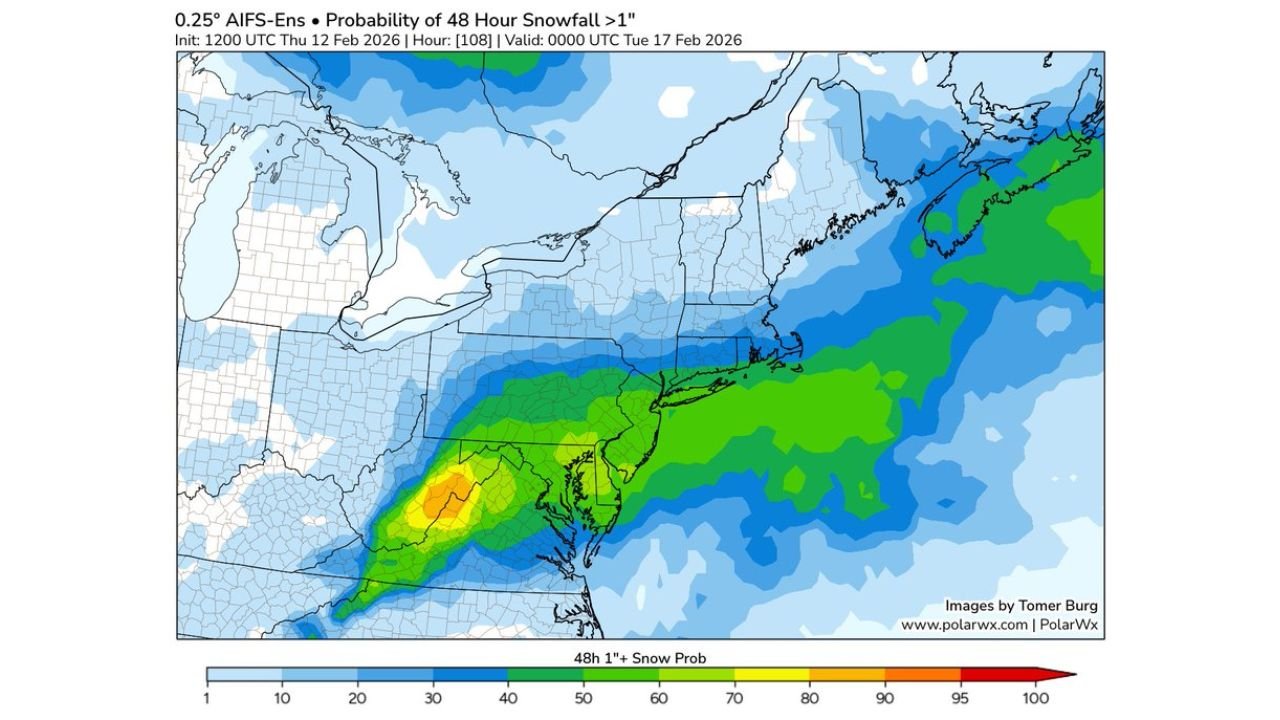
New 48-hour snowfall probability maps valid through early Tuesday show measurable snow chances stretching from central Pennsylvania through northern New Jersey and southern New York, extending into parts of Connecticut and Massachusetts.
The probability for greater than 1 inch of snow shows a broad corridor of modest chances across much of eastern Pennsylvania and New Jersey, with higher probabilities offshore and closer to the coastal Mid-Atlantic.
However, when looking at the greater than 6 inches probability map, the picture tightens significantly. Only a narrower band — primarily across parts of eastern Pennsylvania, central and northern New Jersey, and portions of Maryland and Delaware — shows meaningful odds of heavy snowfall.
This sharp contrast illustrates how most ensemble members are suppressing the storm, while a smaller subset of runs depict a stronger, more impactful system.
Why Forecast Confidence Remains Low
At first glance, it may seem unusual that uncertainty remains high so close to the event window. But this type of pattern often hinges on subtle atmospheric details.
Key factors still in play include:
- Exact storm track relative to the coastline
- Strength of upper-level energy phasing
- Availability of cold air at the surface
- Interaction with coastal low development
A slight northward shift could dramatically increase snowfall totals across the I-95 corridor, while a southern or weaker track would result in minimal impact for most areas.
This kind of setup explains why deterministic models may trend quieter, yet ensembles still flag the possibility of a high-impact outcome.
Low-Likelihood, High-Impact Explained
A low-likelihood, high-impact scenario means the probability of a major event is relatively small — but if it occurs, the consequences would be significant.
In this case, while most ensemble members limit snowfall, those that do produce snow often generate a robust winter storm across parts of the Mid-Atlantic and Northeast.
That creates a forecasting challenge. Forecasters must balance:
- The higher probability of little to modest snow
- Against the smaller but non-negligible chance of a disruptive winter storm
For residents in Philadelphia, central New Jersey, northern Delaware, and southern New York, this means staying alert even if the dominant forecast remains modest.
What Areas Are Most at Risk?
Based on current ensemble guidance, the highest conditional risk zone includes:
- Eastern Pennsylvania
- Northern and central New Jersey
- Northern Delaware
- Maryland’s eastern counties
- Portions of southern New York
Areas farther north into upstate New York and New England show lower heavy-snow probabilities at this time, while regions farther south could end up mostly rain depending on storm evolution.
Final Outlook Before Sunday
As of now, models do not show a locked-in major snowstorm. However, ensemble data makes clear that the threat cannot be fully dismissed.
Small changes in track or temperature could quickly elevate snowfall potential in parts of the Mid-Atlantic. Additional model runs over the next 24–48 hours will be critical in determining whether the stronger ensemble solutions gain support — or fade away.
Residents with travel plans Sunday night into Monday morning should continue monitoring updates, especially in areas with elevated heavy-snow probabilities.
For continued coverage of winter storm developments and regional weather impacts across the Mid-Atlantic and Northeast, visit ChicagoMusicGuide.com.