180-Knot Jet Stream Targets Los Angeles, California as Models Signal 3 to 8+ Inches of Rain Next Week
CALIFORNIA — A powerful Pacific storm is taking aim at Southern California next week, with multiple model runs showing a 250mb jet streak near 180 knots directed straight at Los Angeles from Monday morning through late Wednesday night. The setup, highlighted in Wednesday afternoon guidance, signals a prolonged period of heavy rain and significant impacts across coastal and interior portions of the state.
The latest consistent runs of the European (EU1) and GFS models show the upper-level jet core slamming into the Southern California coastline, creating a strong atmospheric river–type configuration. When jet energy of that magnitude aligns with deep Pacific moisture, it dramatically increases rainfall efficiency — especially along south-facing mountain slopes and coastal terrain.
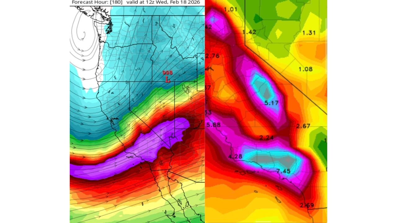
998mb Low and Strong Pacific Feed Drive the Storm
Forecast maps valid around 12z Wednesday, February 18, 2026, show a developing 998mb surface low positioned near or just offshore of California. This low acts as the engine pulling in a broad plume of moisture from the Pacific Ocean.
The rainfall projections on the model graphics indicate:
- 3.7 to 8.5 inches of total rainfall in parts of Southern California
- Widespread totals above 2 to 4 inches across coastal and valley areas
- Higher amounts possible in terrain-favored regions
The most intense precipitation corridor appears focused across Los Angeles County, Ventura County, and surrounding coastal ranges, with heavy bands extending into inland valleys and mountain zones.
Rainfall Bullseyes Over Southern California
Zoomed rainfall guidance highlights localized maxima exceeding 5 inches, with embedded pockets near or above 7 inches in the most persistent bands.
Areas that could see the greatest totals include:
- Coastal slopes and foothills near Los Angeles
- Transverse Ranges and nearby mountain communities
- Parts of Ventura and Santa Barbara counties
- Inland valleys where moisture convergence is strongest
Given the projected rainfall intensity and duration — spanning roughly Monday 8AM through Wednesday 11PM — flooding concerns will likely increase if the forecast verifies.
Why the Jet Stream Matters So Much
A 180-knot jet at 250mb is not just a minor feature — it represents a very strong upper-level wind maximum. When positioned correctly, it enhances:
- Upper-level divergence
- Surface pressure falls
- Vertical motion
- Sustained heavy precipitation bands
In this case, the jet is oriented directly into Southern California, meaning lift and moisture transport remain focused on the same region for an extended window.
That combination is what allows rainfall totals to climb well beyond typical winter storm amounts.
Impacts to Watch Across California
If projected totals materialize, potential impacts may include:
- Urban and small stream flooding
- Mudslide and debris flow risk in burn scar areas
- Rapid rises on creeks and rivers
- Travel disruptions due to heavy rainfall rates
While model fluctuations are still possible, guidance has shown relatively limited changes in overall rainfall magnitude during recent runs, increasing confidence in a significant precipitation event.
Timing Window
Current projections suggest:
- Storm onset: Monday morning
- Peak rainfall intensity: Late Monday through Tuesday
- Lingering showers: Wednesday before tapering late
The prolonged duration is just as important as rainfall intensity, as repeated rounds of moderate to heavy rain can overwhelm drainage systems.
Southern California is no stranger to winter Pacific systems, but the strength of this upper-level jet and the projected rainfall corridor make this one worth watching closely.
We’ll continue to monitor model trends, rainfall updates, and any flood advisories that may develop.
Stay with ChicagoMusicGuide.com for the latest national weather updates and regional impact analysis as this California storm evolves.