Washington, D.C. and Northern Virginia to See 0.3–0.6 Inches of Steady Rain Through Sunday Night, Offering Drought Relief and Snowpack Melt
WASHINGTON, D.C. — A steady, soaking rain is moving into the D.C. metro area and surrounding portions of Northern Virginia and Maryland, with forecast totals ranging from 0.3 to 0.6 inches through Sunday night, gradually tapering off around midnight. While not a high-impact storm, this rainfall is shaping up to be a beneficial event for the region.
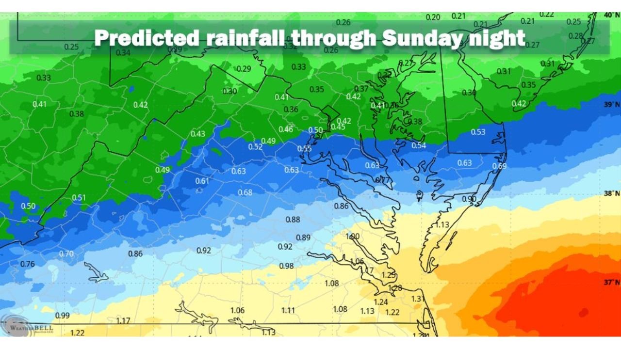
Forecast guidance shows a clear north-to-south gradient in rainfall totals, with the heaviest amounts south of the Beltway and lighter but still meaningful totals across the immediate D.C. corridor.
Rainfall Totals Across the D.C. Metro Area
Model projections indicate:
- Washington, D.C.: Around 0.4 to 0.5 inches
- Arlington, Alexandria, Fairfax (Northern Virginia): Approximately 0.5 to 0.6 inches
- Montgomery and Prince George’s Counties (Maryland): Near 0.4 to 0.5 inches
- Southern Maryland and southern Virginia: Locally higher amounts, nearing 0.8 to 1.2 inches
The core D.C. area remains in a moderate rainfall zone — enough to thoroughly wet the ground without triggering widespread flooding concerns.
Why This Rain Is Actually Welcome News
Although it brings gray skies and wet roads, this rainfall carries several important benefits for the Mid-Atlantic region.
Chipping Away at Lingering Snow and Ice
After a colder stretch that allowed snow and ice to compact into stubborn patches, this steady rain will help soften and erode what many refer to as “snowcrete.” Combined with above-freezing temperatures, the rainfall will gradually break down remaining icy layers, particularly in shaded and urban areas.
Providing a Modest Drought Boost
Parts of the Mid-Atlantic have been running dry. While half an inch of rain won’t erase drought conditions, it will make a noticeable dent in soil moisture deficits. Because the rainfall is steady rather than torrential, more of it can soak into the ground rather than run off immediately.
Minimal Flood Risk Expected
This system is not forecast to produce intense rainfall rates. Instead, residents can expect:
- Periods of steady light to moderate rain
- Wet roadways and reduced visibility at times
- Minor ponding in low-lying areas
- No widespread flash flooding concerns
The rain is expected to gradually wind down around or shortly after midnight Sunday.
Broader Mid-Atlantic Rainfall Pattern
Across the region:
- Northern Maryland and parts of Pennsylvania may see closer to 0.3–0.4 inches
- D.C. and Northern Virginia sit in the 0.4–0.6 inch corridor
- Southern Virginia and coastal areas could receive 1 inch or more
This pattern reinforces that the heaviest moisture remains south of the immediate D.C. urban core.
What Happens Next?
As the rain exits Sunday night, drier conditions are expected to return early next week. Temperatures should remain above freezing during the rainfall event, preventing winter weather complications.
Overall, this is shaping up to be a steady, helpful rain event — not dramatic, but meaningful. It will:
- Improve soil moisture
- Gradually melt lingering snowpack
- Provide modest drought relief
- Avoid major flooding impacts
For continued updates on impactful weather patterns across the country, stay tuned to ChicagoMusicGuide.com as we monitor conditions nationwide and keep you informed on what’s next.