Sun–Mon Snowstorm Threat Intensifies Across Pennsylvania, New York, and New England as Models Signal 6+ Inch Potential
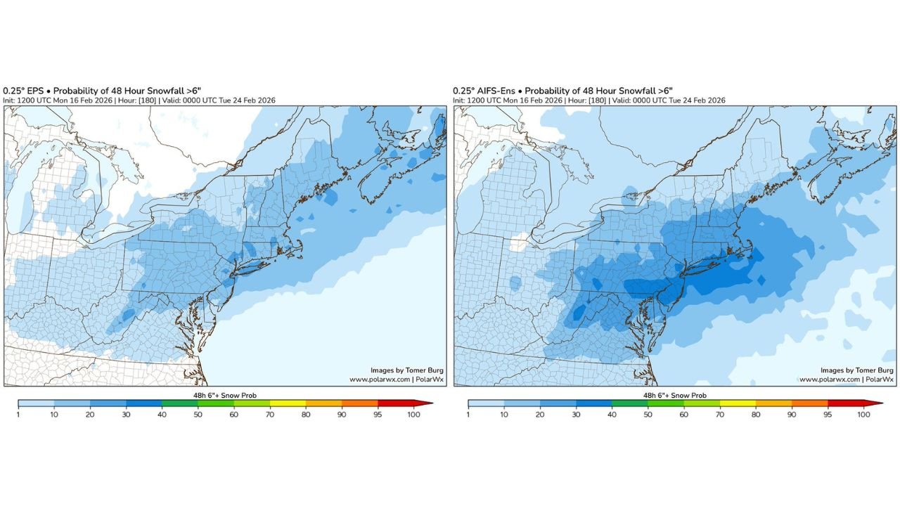
NEW YORK, NEW YORK — A developing Sunday into Monday storm system is drawing heightened attention as ensemble forecast guidance shows low but meaningful probabilities of a 6-inch or greater snowfall across parts of Pennsylvania, New York, and New England. While deterministic models remain volatile, the broader ensemble signal suggests that a winter storm scenario cannot be ruled out for the Northeast early next week.
Forecast probability maps valid through Tuesday, February 24, indicate a growing corridor of measurable snowfall risk extending from the Mid-Atlantic through southern and central New England.
Ensemble Models Show Expanding 6+ Inch Snow Signal
Recent 48-hour snowfall probability guidance highlights a widespread but moderate signal for accumulating snow across the Northeast. The most consistent ensemble support currently focuses on:
- Eastern and central Pennsylvania
- Southern and eastern New York
- New Jersey
- Connecticut
- Rhode Island
- Massachusetts
Several ensemble members show enhanced probabilities near the I-95 corridor, including areas surrounding New York City, Philadelphia, and Hartford. Coastal sections of southern New England also appear within the developing snow risk zone, though totals will depend heavily on storm track and coastal dynamics.
While probabilities are not yet extremely high, the consistency across multiple ensemble systems suggests a storm worth monitoring closely.
Deterministic Guidance Remains Highly Volatile
Forecasters emphasize that individual deterministic model runs continue to shift significantly from cycle to cycle. That volatility reflects uncertainty in several key elements:
- Exact placement of the surface low
- Interaction between northern and southern stream energy
- Timing of coastal development
- Thermal profiles near major metropolitan areas
A slight northward shift could push heavier snow into interior New York and New England. A southward or offshore solution could dramatically reduce impacts. This level of variability is typical at this range, but ensemble clustering provides early signals that snowfall potential remains on the table.
Pennsylvania to Coastal New England in the Primary Risk Zone
The current probability pattern places the greatest overlap of snowfall risk across:
Pennsylvania:
Central and eastern sections, including areas north and west of Philadelphia, show measurable potential for 6 inches or more.
New York:
The Hudson Valley, New York City metro area, and portions of southern New York fall within a moderate probability zone. Interior locations could see stronger snowfall if colder air remains firmly in place.
New England:
Connecticut, Rhode Island, and much of Massachusetts are included in the ensemble snowfall corridor. Coastal communities will be especially sensitive to storm track and marine air intrusion.
Northern areas such as interior upstate New York and northern New England show lighter probabilities at this time but remain within the broader cold pattern.
Timing Window: Late Sunday Through Early Monday
If the system develops as some ensemble members suggest, the primary impact window would occur late Sunday into early Monday. This timing could affect early-week travel across the Northeast, particularly along heavily traveled corridors such as Interstate 95.
Key forecast factors still under evaluation include:
- Strength of cold air in place ahead of the storm
- Degree of coastal amplification
- Phasing of upper-level energy
Should these ingredients align, snowfall rates could briefly become moderate to heavy in parts of the Northeast. However, forecasters stress that this is a potential setup — not a confirmed major snowstorm.
Confidence Still Moderate, But Trend Worth Watching
The overall message remains one of cautious attention. Ensemble probabilities show increasing but not guaranteed odds of a meaningful snowfall event. It remains too early to assign specific snowfall totals or pinpoint exact impact zones.
Forecast clarity is expected to improve over the next several days as models converge on a more stable solution. Until then, residents across Pennsylvania, New York, New Jersey, and New England should monitor updates and remain aware of possible winter weather impacts heading into the start of next week.
As this developing Sunday–Monday storm scenario evolves, ChicagoMusicGuide.com will continue tracking model trends, snowfall probabilities, and regional impacts across the Northeast. For ongoing updates on winter weather patterns affecting major cities and travel corridors, visit ChicagoMusicGuide.com.