Texas to Mississippi Valley Under Heightened Severe Weather Watch March 5–10 as Plains Pattern Expands Toward Dixie Alley
OKLAHOMA CITY, OKLAHOMA — Forecast guidance indicates that severe weather will be possible from March 5 through at least March 10, with the highest early focus centered over the Central to Southern Plains, including Oklahoma, North Texas, and parts of Kansas, before potentially expanding east into Arkansas, Louisiana, Mississippi, Alabama, and Tennessee.
Multiple ensemble and composite parameters show increasing signals for organized thunderstorms during this window, though meteorologists stress that specific outbreak timing and intensity will be refined closer to the event.
Ensemble Trends Show Increasing Severe Signal
The GEFS daily summed severe parameter trends display a noticeable upward shift beginning around March 5, continuing through March 10. While variability remains in individual ensemble members, the mean trend shows a clear bump in severe potential during this period.
This increase aligns with strengthening upper-level dynamics and improved moisture return from the Gulf of Mexico. When ensemble averages begin trending upward several days in advance, it typically signals a broader atmospheric pattern becoming more supportive of severe convection.
The highlighted timeframe suggests multiple opportunities for storms rather than a single isolated day.
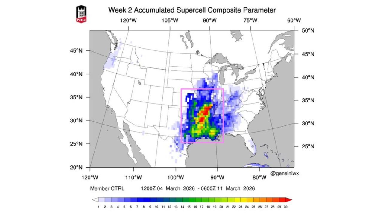
Supercell Composite Focused on Central and Southern Plains
Week 2 accumulated Supercell Composite Parameter (SCP) projections concentrate the strongest signals across:
- Central and eastern Oklahoma
- North and central Texas
- Southern Kansas
- Western Arkansas
The most intense clustering appears near the Red River region and central Oklahoma, a corridor historically favorable for early-season supercell development.
Supercell composite values indicate the potential for rotating thunderstorms capable of producing:
- Damaging wind gusts
- Large hail
- Isolated tornadoes
Although precise storm mode will depend on smaller-scale features closer to event time, the broader signal suggests the Plains will likely be the initial focus.
Jet Stream Pattern Supports Organized Storm Development
Upper-level wind projections show a strengthening 500mb jet stream segment extending from Texas into the Lower Mississippi Valley during the March 6–8 window.
This jet configuration enhances:
- Vertical wind shear
- Storm organization potential
- Large-scale lift
The pattern shows a trough positioned over the western United States with strong southwest flow overspreading Texas, Oklahoma, Arkansas, and Louisiana. Such setups frequently support multi-day severe weather episodes across the Southern Plains before shifting eastward.
Expansion Toward Dixie Alley Possible
As the jet stream advances eastward later in the period, guidance suggests the severe threat could expand into portions of:
- Arkansas
- Northern Louisiana
- Mississippi
- Alabama
- Western Tennessee
This region, often referred to as Dixie Alley, is particularly vulnerable during early spring due to strong wind shear and abundant Gulf moisture.
While March outbreaks can vary widely in intensity, historical patterns show that Plains-origin systems frequently track east into the Mississippi Valley within a few days.
Uncertainty Remains, But Window Bears Watching
Forecasters caution that this outlook remains several days away, meaning storm placement and severity levels will evolve. However, the consistency across:
- Ensemble severe parameter trends
- Supercell composite projections
- Jet stream alignment
adds confidence that the March 5–10 timeframe deserves close monitoring.
Residents in Oklahoma City, Tulsa, Dallas, Wichita Falls, Little Rock, Shreveport, Jackson, Birmingham, and Memphis should stay alert for updated forecasts as the window approaches.
Early March Transition Pattern Taking Shape
The broader atmospheric pattern reflects a seasonal transition, where increasing warmth, strengthening jet dynamics, and deepening Gulf moisture begin interacting more frequently.
For the Central and Southern Plains, this typically marks the start of a more active severe weather season. As systems organize and track eastward, the Mississippi Valley and Deep South often follow.
Although it is too early to determine whether this period will produce isolated events or a more widespread outbreak, the pattern strongly favors at least some severe potential.
As March approaches, preparedness remains key across Oklahoma, Texas, and the broader Mississippi Valley. For ongoing updates on severe weather trends, Plains storm development, and potential impacts across the South and Midwest, visit ChicagoMusicGuide.com.