Arkansas to Ohio Valley in Focus as Early–Mid March Pattern Shift Signals Heavy Rain and Possible Severe Thunderstorms
LITTLE ROCK, ARKANSAS — Forecast models are increasingly aligning around a significant pattern shift across the United States in early to mid-March, with the central U.S. positioned beneath a corridor of heavy rainfall and potential thunderstorms. While still several days away, ensemble agreement suggests a dynamic setup that could bring widespread precipitation from the Southern Plains through the Mississippi Valley and into the Ohio Valley.
Meteorologists caution that specific severe weather details remain uncertain, but the large-scale signals are strong enough to warrant attention.
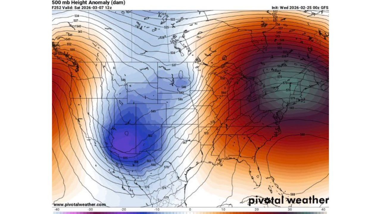
Strong Trough-West, Ridge-East Setup Emerging
The 500mb height anomaly maps show a pronounced upper-level trough digging into the western United States, centered over parts of Arizona, New Mexico, and West Texas, while a strong ridge builds across the eastern half of the country.
This classic configuration supports:
- Southwest flow aloft across the Plains
- Gulf moisture transport northward
- Repeated storm system development
The ridge positioned over the Southeast and Mid-Atlantic enhances temperature contrasts between western and eastern air masses, strengthening the overall storm track.
Such amplified patterns are often associated with active severe weather periods during March.
Heavy Rain Corridor Extends from Texas to the Great Lakes
The 120-hour quantitative precipitation forecast (QPF) highlights a broad swath of heavy rainfall stretching from:
- North and East Texas
- Arkansas
- Louisiana
- Mississippi
- Tennessee
- Kentucky
- Southern Illinois
- Indiana
- Into portions of the Ohio Valley and Great Lakes
The most intense rainfall shading appears concentrated across Arkansas, western Tennessee, northern Mississippi, and western Kentucky, suggesting several inches of rain may fall during the early March window.
This axis aligns with the expected storm track beneath the strengthening upper-level jet.
Potential for Thunderstorms and Severe Weather
With a western trough and eastern ridge in place, the thermodynamic environment could support thunderstorms — and possibly severe storms — depending on how instability and wind shear align as the event approaches.
The southwest flow aloft over the Southern Plains and Mississippi Valley enhances vertical wind shear, a critical ingredient for organized storms. Meanwhile, Gulf moisture streaming northward raises the possibility of:
- Strong thunderstorms
- Damaging winds
- Large hail
- Isolated tornado risk
At this stage, forecasters emphasize that thermodynamic details will determine the magnitude of any severe threat. However, the broader pattern is consistent with early-season severe setups.
Mississippi Valley and Mid-South Bear Watching
The region from Dallas to Little Rock to Memphis to Louisville sits directly under the projected storm corridor. If the pattern verifies, multiple waves of rain and storms could track along this axis.
Areas particularly worth monitoring include:
- Central and eastern Arkansas
- Western Tennessee
- Northern Mississippi
- Southern Illinois
- Western Kentucky
Repeated rounds of rainfall could also raise localized flooding concerns, especially in areas where soils become saturated.
Models Showing Growing Agreement
One of the more notable aspects of this forecast is that multiple model cycles are beginning to converge on the same general pattern. While exact storm placement will continue to evolve, early consensus often increases confidence in the overall setup.
The projected trough-and-ridge alignment is a textbook early-spring configuration that frequently produces impactful weather across the central and eastern United States.
Still Several Days Away, But Worth Monitoring
Although details remain limited this far out, the consistency in model output suggests early to mid-March could bring:
- Widespread heavy rainfall
- Multiple storm systems
- Potential for severe weather depending on instability
Residents across Arkansas, Texas, Louisiana, Mississippi, Tennessee, Kentucky, Illinois, and Indiana should stay alert for updated forecasts as the timeframe draws closer.
As the early–mid March window approaches, preparation and awareness will be key across the Mississippi Valley and Southern Plains. For continued updates on developing storm systems, heavy rain risks, and potential severe weather trends, visit ChicagoMusicGuide.com.