Orlando, Ocala and Daytona Beach in Target Zone as Central Florida Braces for Late-Friday Storms Amid Extreme Drought Concerns
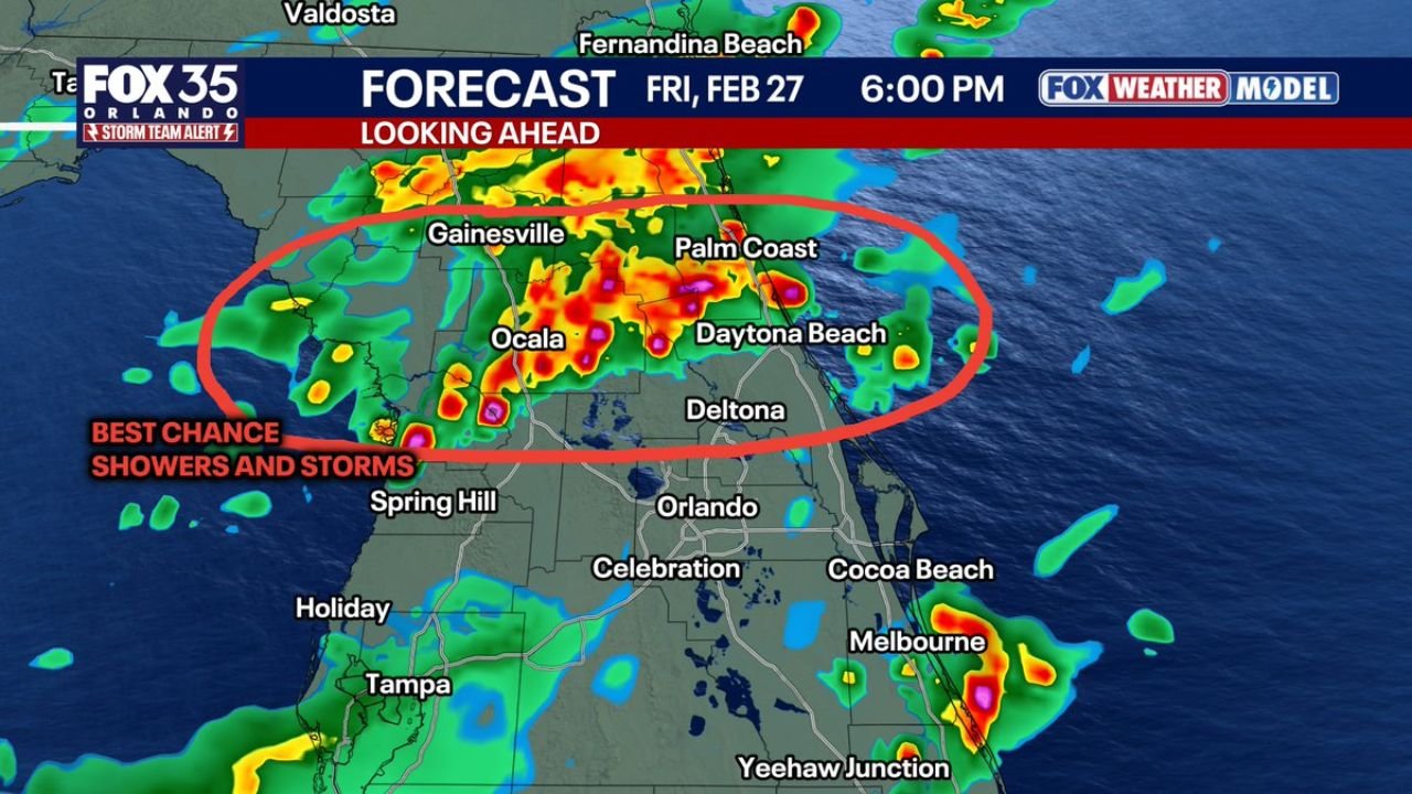
FLORIDA — Rain and scattered thunderstorms are forecast to develop across central Florida Friday afternoon and evening, with the most concentrated activity stretching from Ocala through Gainesville and Palm Coast to Daytona Beach.
Forecast model guidance valid around 6:00 PM Friday shows a corridor of heavier showers and storms pushing west to east across the region. The highest storm coverage appears north of Orlando, with a pronounced band extending across:
- Gainesville
- Ocala
- Palm Coast
- Daytona Beach
Meanwhile, additional scattered activity is visible near Melbourne along the east-central coast and portions of the I-4 corridor.
Best Chance for Showers and Storms
The strongest signals for thunderstorms are concentrated across north-central and east-central Florida, particularly between Ocala and Daytona Beach. Embedded heavier cells within that band could produce:
- Frequent lightning
- Brief heavy rainfall
- Gusty winds
The activity is expected to move from west to east during the late afternoon and evening hours, meaning inland areas such as Ocala and Gainesville may see storms first before they track toward Palm Coast and Daytona Beach.
Lightning a Major Concern
While rain is generally beneficial, especially in dry conditions, lightning presents a unique concern across Florida.
With parts of the state experiencing extreme drought conditions, lightning strikes — even during rain events — can ignite new wildfires quickly if rainfall is uneven or short-lived.
Dry vegetation combined with gusty winds can allow any new ignition to spread rapidly, particularly in wooded or brush-heavy areas near Ocala and rural stretches west of Daytona Beach.
Orlando Area: Lower but Not Zero Risk
The Orlando metro area appears just south of the primary storm axis, though scattered showers could still develop nearby. Areas such as:
- Orlando
- Deltona
- Celebration
may see spotty rainfall, but the highest storm concentration is projected north of the city.
Residents should still monitor radar trends, as Florida convection can shift quickly with subtle boundary changes.
Coastal Storms Also Possible
Farther south along the Atlantic coast, isolated stronger cells are indicated near Melbourne and offshore waters. These storms may produce localized downpours and lightning before drifting eastward into the Atlantic.
What to Expect Friday Evening
Timing suggests:
- Storms developing inland during mid to late afternoon
- Eastward movement toward the coast into the early evening
- Gradual weakening after sunset
Not everyone will see rain, but where storms develop, impacts could be briefly intense.
Bottom Line
Central Florida — especially Ocala, Gainesville, Palm Coast and Daytona Beach — sits in the best zone for Friday evening thunderstorms. While rainfall will be welcomed in drought-stricken areas, lightning remains a significant wildfire concern.
Residents should stay weather-aware late Friday as storms move from west to east across the region.
For continued national and regional weather updates, stay with ChicagoMusicGuide.com.