Active Jet Stream Pattern to Bring Severe Storms from Texas to Ohio Valley and Late-Season Snow to Midwest and Great Lakes Through March 9
UNITED STATES — A significantly more active weather pattern is preparing to unfold across the country over the next two weeks, with multiple storm systems expected to track from the Plains into the Midwest and East.
Forecast guidance shows an amplified jet stream setting up across the United States, a configuration that often supports repeated storm development. The result could be multiple rounds of severe weather across the South and Ohio Valley, along with periods of accumulating snow on the colder side of these systems across the Central Plains, Midwest, and Great Lakes.
Severe Weather Risk from Texas to the Ohio Valley
The developing pattern favors storm tracks beginning across:
- Texas
- Oklahoma
- Arkansas
- Louisiana
Storms are then expected to advance northeast into:
- The Mississippi Valley
- The Tennessee Valley
- The Ohio Valley
Cities such as Dallas, Oklahoma City, Little Rock, Memphis, Nashville, Louisville, and Cincinnati could see multiple opportunities for strong to severe thunderstorms as waves eject from the Plains.
With Gulf moisture returning northward ahead of each system, the setup may support:
- Damaging winds
- Large hail
- Tornado potential
- Heavy rainfall
Exact timing for each severe weather round will become clearer in the coming days, but the overall pattern signals repeated storm chances rather than a single isolated event.
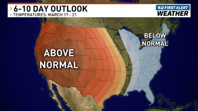
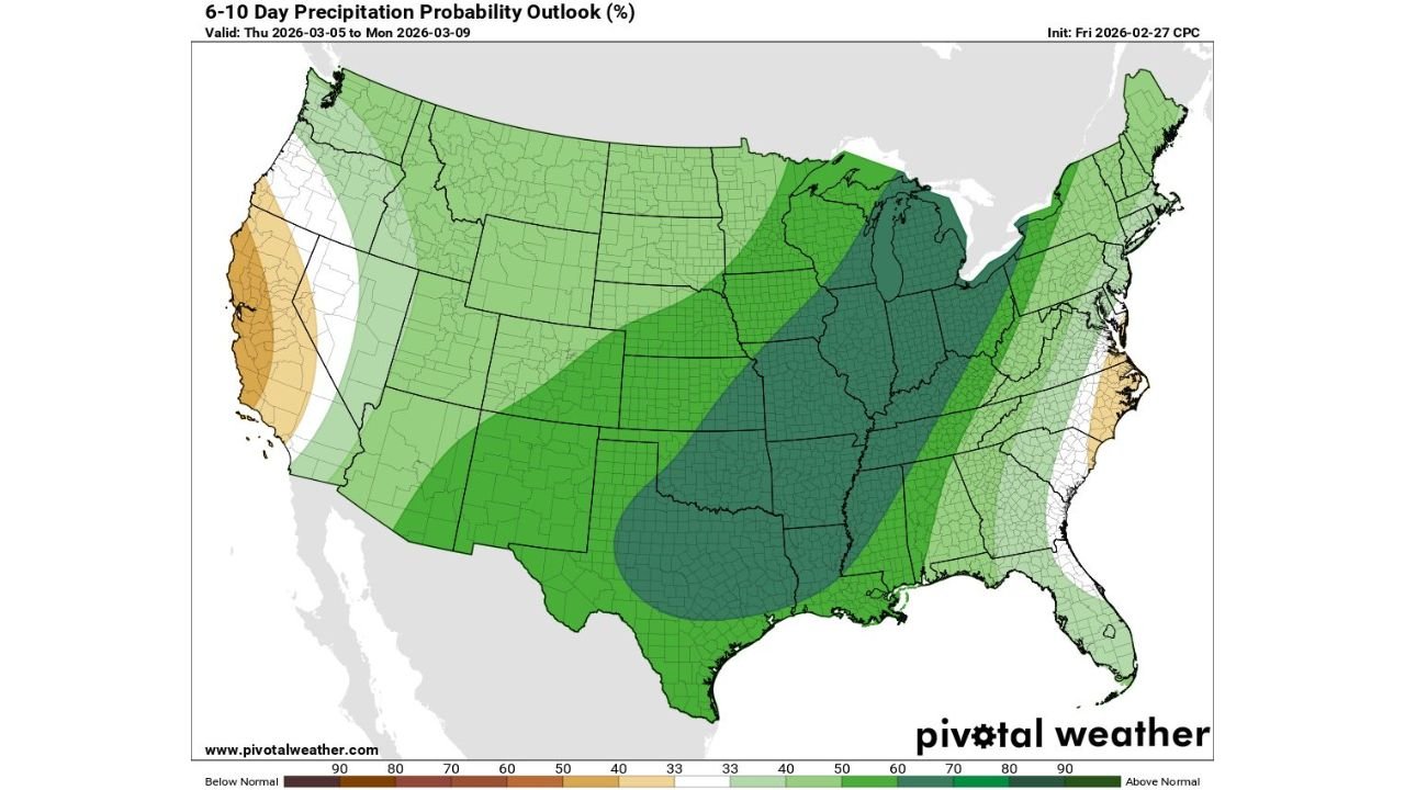
Above-Normal Precipitation Signal Expands Across the Midwest and Great Lakes
The 6–10 day precipitation outlook (valid March 5–9) highlights a broad swath of above-normal precipitation probabilities extending from:
- Eastern Texas
- Oklahoma and Kansas
- Through Missouri and Arkansas
- Into Illinois, Indiana, Ohio
- Northward into Michigan and Wisconsin
The darker green shading across the Great Lakes region, including Chicago, Detroit, Milwaukee, Indianapolis, and Cleveland, suggests a strong signal for wetter-than-normal conditions during this window.
This supports the idea of multiple storm systems moving through the region.
Late-Season Snow Potential for the Colder Side
While severe weather dominates the southern tier, colder air wrapping into these systems may produce accumulating snow across:
- Portions of the Central Plains
- The Upper Midwest
- The Great Lakes
- Possibly interior sections of the Northeast
Areas north and west of the main severe weather corridor — including parts of Minnesota, Wisconsin, northern Illinois, Michigan, and northern Indiana — could find themselves on the colder side of individual storm tracks.
Given that we are entering early March, snow placement will be highly track-dependent, meaning small shifts could dramatically change who sees rain versus snow.
Amplified Jet Stream Driving the Setup
An amplified jet stream pattern typically features:
- Deep troughs over the western or central U.S.
- Strong ridging downstream
- Increased storm intensity
- More frequent storm development
This pattern favors repeated rounds of active weather rather than extended quiet stretches.
As energy ejects from the western trough into the Plains, it can trigger severe weather across the South while simultaneously generating wintry impacts farther north.
What This Means for Chicago and the Great Lakes
For the Chicago metro and surrounding Midwest communities:
- Expect multiple precipitation chances between March 5–9
- Monitor potential for at least one system to bring accumulating snow
- Prepare for fluctuating temperatures depending on storm track
For southern states from Texas to the Ohio Valley, the focus will be on severe weather preparedness as instability and wind shear align during individual storm passages.
Bottom Line
An active pattern is set to take shape across the United States over the next two weeks, bringing:
- Repeated severe weather opportunities from Texas through the Mississippi and Ohio Valleys
- Above-normal precipitation across the Midwest and Great Lakes
- Potential late-season snowfall on the colder northern side of these systems
As this amplified jet stream pattern develops, details on timing and placement will sharpen. For now, confidence is growing that early March will be anything but quiet.
Stay with ChicagoMusicGuide.com for continued updates as this multi-system pattern begins to unfold.