Minnesota, Wisconsin, Michigan, Iowa, and Illinois Face Major Weekend Winter Storm With 8+ Inches Likely From Minneapolis and Duluth to Milwaukee and Marquette
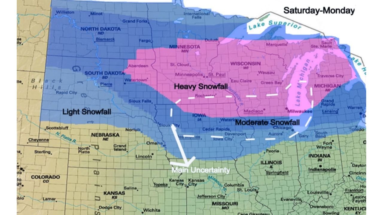
MINNEAPOLIS, MINNESOTA — A major winter storm is expected to develop this weekend and continue into Monday, bringing the potential for significant snowfall totals of 8 inches or more across portions of Minnesota, Wisconsin, and Michigan, while moderate accumulations extend southward into Iowa and northern Illinois.
Forecast mapping highlights a broad swath of heavy snow centered over the Upper Midwest, with impacts likely to intensify from Saturday through early next week.
Heavy Snow Zone: Minnesota, Wisconsin, and Michigan
The core of the storm is projected to stretch from central and northern Minnesota through much of Wisconsin and into northern and central Michigan.
Cities that may fall within the heavier snowfall axis include:
- Minneapolis–St. Paul
- St. Cloud
- Duluth
- Wausau
- Green Bay
- Marquette
- Areas near Lake Michigan and Lake Superior
This region is highlighted for heavy snowfall, where totals of 8 inches or more appear increasingly likely. The storm’s track suggests strong forcing across this corridor, enhancing snowfall rates and increasing the potential for widespread travel disruptions.
Lake-enhanced effects near Lake Superior and Lake Michigan could locally boost totals, particularly in parts of northern Wisconsin and Michigan’s Upper Peninsula.
Moderate Snow Extending Into Iowa and Northern Illinois
South of the heavy snow band, a zone of moderate snowfall is projected across northern Iowa and into northern Illinois, including areas near:
- Cedar Rapids
- Davenport
- The Chicago metro region
- Portions of southern Wisconsin
While snowfall totals here may be lower than in the heavy band to the north, several inches of accumulation remain possible. This could still result in slick roads and reduced visibility during peak snowfall periods.
Light Snow Across the Dakotas and Western Nebraska
Farther west, lighter snowfall is expected across parts of:
- North Dakota
- South Dakota
- Western Nebraska
Though accumulations in this region may be less significant, snow-covered roads and localized impacts remain possible, especially in rural and open areas where blowing snow could become an issue.
Main Uncertainty Near Kansas City and Missouri
The southern edge of the storm system carries notable uncertainty. A marked “main uncertainty” zone extends near Kansas City, northern Missouri, and into eastern Kansas.
Small shifts in the storm track could significantly alter snowfall totals in this corridor. If the system trends slightly north or south, areas currently on the edge could either see accumulating snow or remain largely rain.
Timing: Saturday Through Monday
The storm is expected to unfold beginning Saturday, intensifying through Sunday, and potentially lingering into Monday in parts of the Great Lakes region.
Given the multi-day nature of the system, snowfall totals will accumulate over time, increasing the risk of:
- Difficult travel conditions
- Delayed flights in major hubs such as Minneapolis and Chicago
- Hazardous rural roadways across Minnesota, Wisconsin, and Michigan
Residents across the Upper Midwest should prepare for winter driving conditions and monitor local updates as the storm track becomes more refined.
For continued updates on major winter systems and regional impacts across the United States, visit ChicagoMusicGuide.com.