Dangerous Overlap Emerges From Memphis and Nashville to Louisville and Indianapolis as 70 MPH Wind Threat Targets Regions Still Recovering From January Ice Storm
NASHVILLE, TENNESSEE — A growing severe weather threat Sunday night is raising new concerns across parts of the Mid-South and lower Ohio Valley — not just because of the potential for 70 mph wind gusts, but because many of these same communities are still recovering from January’s catastrophic ice storm.
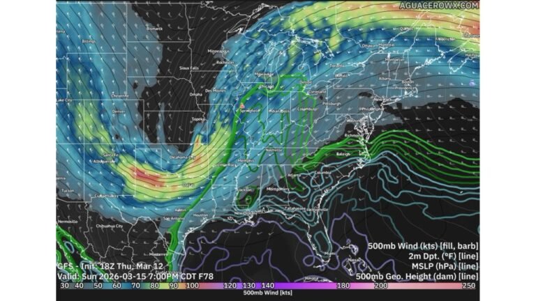
Forecast maps show a high-probability severe weather corridor stretching from northeast Arkansas through western and middle Tennessee, southern Kentucky, southern Illinois and into central Indiana — areas that were heavily impacted by significant ice accumulations earlier this year.
January Ice Storm Left Lasting Damage
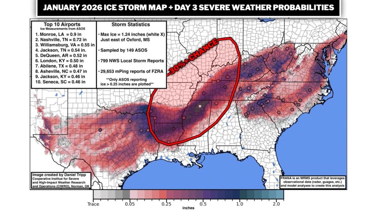
The January 2026 ice storm brought substantial glaze accumulations across a wide swath of the South and lower Midwest.
Reported ice totals included:
- Nashville, Tennessee — 0.72 inches
- Jackson, Tennessee — 0.54 inches
- DeQueen, Arkansas — 0.52 inches
- London, Kentucky — 0.50 inches
- Asheville, North Carolina — 0.47 inches
- Monroe, Louisiana — 0.9 inches
The maximum reported ice accumulation reached 1.24 inches just east of Oxford, Mississippi.
Thousands of local storm reports were logged, and nearly 30,000 mPing reports of freezing rain were recorded. Trees, limbs and power infrastructure suffered extensive damage — and full recovery has been slow in many communities.
Severe Wind Threat Now Overlapping Ice Damage Zone
Now, the Day 3 severe weather outlook shows a 30 percent or greater probability of severe storms across much of that same corridor.
The highlighted zone includes:
- Memphis, Tennessee
- Nashville, Tennessee
- Clarksville, Tennessee
- Evansville, Indiana
- Louisville, Kentucky
- Portions of southern Illinois
This alignment is particularly concerning because many trees weakened or partially damaged during January’s ice event remain structurally compromised.
If widespread wind gusts of 70 mph or greater materialize Sunday night, the risk of tree failures could be significantly elevated compared to a typical wind event.
Power Outage Risk Could Be Higher Than Usual
The primary severe hazard appears to be damaging straight-line winds from a fast-moving squall line.
In areas where ice accumulation previously stressed trees and utility lines, even slightly lower wind speeds could produce:
- Increased tree fall
- Expanded power outages
- Longer restoration times
- Road blockages
Middle Tennessee, including Nashville and surrounding counties, may be especially vulnerable given the documented ice damage earlier this winter.
Strong Squall Line Expected
Meteorologists continue to signal the likelihood of a strongly forced line of storms developing Sunday evening and surging northeast overnight.
Embedded tornadoes remain possible, but the larger and more widespread threat appears to be wind damage.
This will be a fast-moving system, meaning impacts could occur quickly and spread across multiple states within just a few hours.
Preparation Urged
Residents across Tennessee, Kentucky, southern Illinois and Indiana should prepare not only for severe weather — but for the realistic possibility of extended power outages.
Officials recommend:
- Charging devices in advance
- Having flashlights and backup batteries ready
- Securing outdoor objects
- Reviewing severe weather safety plans
The overlap between January’s ice damage footprint and Sunday night’s high wind corridor creates an elevated vulnerability that should not be overlooked.
Stay with ChicagoMusicGuide.com for continuing updates as timing and impact details become clearer heading into Sunday night.