Georgia, South Carolina and North Carolina Face Rare Level 4 Moderate Risk as SPC Signals High-End Wind Damage Threat From Atlanta to Charlotte and Raleigh on Monday
ATLANTA, GEORGIA — The Storm Prediction Center is now discussing a potential upgrade to a Level 4 out of 5 Moderate Risk for severe weather across parts of Georgia, South Carolina and North Carolina on Monday, underscoring growing concern about widespread and potentially destructive wind damage.
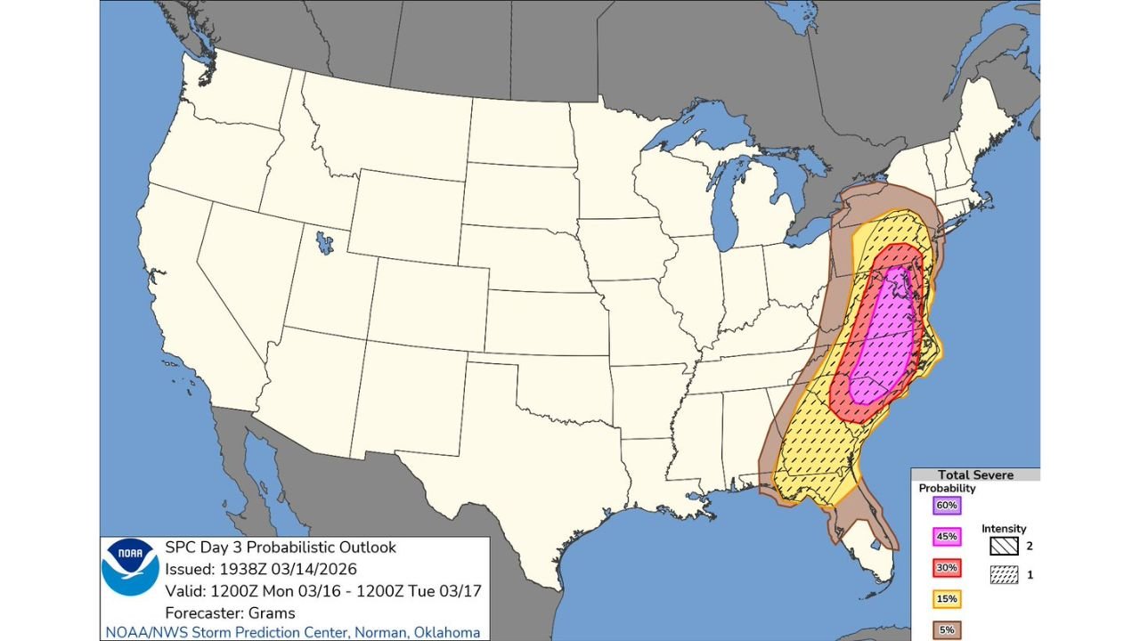
According to the latest Day 3 probabilistic outlook valid Monday into early Tuesday, a broad corridor of significant severe weather stretches from northern Florida through Georgia and the Carolinas, reaching as far north as portions of Virginia and Pennsylvania.
Rare Moderate Risk on the Table
Moderate Risk designations are not issued often for this region. Forecasters noted that only a handful have been issued in past records for this area, highlighting the magnitude of concern for Monday’s setup.
The highest probabilities currently focus on:
- Atlanta, Georgia
- Augusta, Georgia
- Columbia, South Carolina
- Charlotte, North Carolina
- Raleigh, North Carolina
The core of the highest severe probabilities — including 45% and 60% zones — runs from central Georgia through South Carolina into central North Carolina.
Wind Damage the Primary Concern
Forecasters are particularly focused on high-end wind potential.
The outlook map shows hatched probability zones, signaling the risk for significant severe weather — including wind gusts capable of causing structural damage and widespread power outages.
If upgraded to Level 4 Moderate Risk, it would signal confidence in:
- Numerous severe reports
- Organized squall lines
- Long swaths of damaging winds
Given the orientation of the risk corridor, a powerful line of storms could sweep northeast from Georgia into the Carolinas during peak daytime or evening hours Monday.
Tornado Risk Also Present
While wind appears to be the dominant threat, embedded tornadoes remain possible within the broader severe zone.
The probabilistic map includes enhanced severe totals across Georgia and the Carolinas, meaning rotating storms could develop within or ahead of the main line.
Areas from Atlanta, Georgia through Columbia, South Carolina and into Charlotte and Raleigh, North Carolina should closely monitor forecast updates.
Geographic Extent of the Threat
The severe corridor stretches from:
- Northern Florida
- Central and eastern Georgia
- Much of South Carolina
- Central and eastern North Carolina
- Into southern Virginia
The highest probabilities remain centered over Georgia and the Carolinas, where instability and strong wind shear are expected to overlap.
Why This Upgrade Matters
Moderate Risk forecasts signal high confidence in widespread severe weather.
For cities like Atlanta, Georgia; Columbia, South Carolina; and Charlotte, North Carolina, this could mean:
- Extensive tree damage
- Power outages
- Travel disruptions
- Potential school and business impacts
Forecasters emphasized that discussions about upgrading to Moderate Risk reflect serious concern about wind damage potential.
Timing and Next Steps
The outlook is valid from Monday morning through early Tuesday.
Additional refinements are expected as the Day 2 and Day 1 outlooks are issued. If the Moderate Risk is officially posted, it would be one of the more significant severe setups for this region in recent years.
Residents across Georgia, South Carolina and North Carolina are urged to review severe weather safety plans now and ensure multiple ways to receive warnings are in place.
Stay with ChicagoMusicGuide.com for continued updates as the SPC finalizes risk categories and watches are issued.