Texas, Louisiana, Mississippi and Tennessee Enter Dangerous Late March Severe Storm Zone as Deep South Faces Explosive Weather Pattern Shift
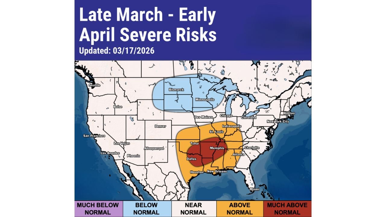
UNITED STATES — A developing late March to early April 2026 weather pattern is placing Texas, Louisiana, Mississippi, and Tennessee directly in the path of a growing severe storm threat, with meteorologists highlighting the Deep South and Tennessee Valley as the primary risk corridor. Forecast data updated on March 17, 2026 shows a concentrated zone of warm, unstable air that could lead to multiple rounds of strong storms.
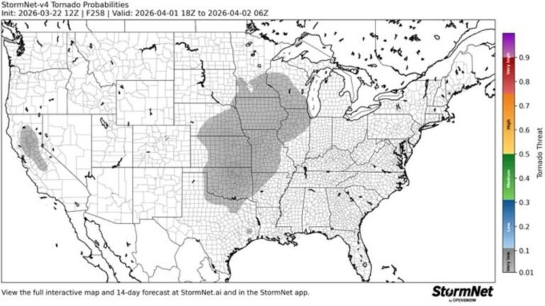
The highest concern centers on a clear “bullseye” stretching from Dallas, Texas to Memphis, Tennessee, where atmospheric conditions are expected to become increasingly favorable for severe thunderstorms, heavy rainfall, and possible tornado activity as the pattern strengthens into early April.
Deep South Severe Weather Corridor Expands Across Texas, Louisiana and Mississippi
The latest outlook places Texas, Louisiana, and Mississippi at the core of the severe weather corridor, where above-normal temperatures and high moisture levels are combining to create an unstable environment. This setup is driven by warm Gulf air pushing northward, interacting with incoming weather systems.
Major cities including Dallas, Houston, and New Orleans are positioned within the most intense zone, where forecast models indicate the potential for damaging winds, large hail, and isolated tornadoes. The presence of a deep red zone on the map highlights where conditions could become most volatile.
Surrounding areas, including parts of Arkansas and eastern Oklahoma, are also expected to experience elevated storm risks. This suggests the severe weather threat will not be isolated but could impact a wide portion of the Southern United States.
Tennessee Valley Including Memphis Faces Increasing Storm Risks
As the pattern evolves, the severe weather threat is expected to expand into the Tennessee Valley, with Memphis, Tennessee identified as a key impact zone. The region will remain under persistent warm and unstable air, creating ideal conditions for repeated storm development.
Unlike single-day events, this setup may produce multiple rounds of storms over several days, increasing the risk of flash flooding and prolonged severe weather impacts. The consistency of this pattern is one of the primary concerns for meteorologists.
Cities such as Nashville, Tennessee and surrounding areas may also see increasing impacts as the storm corridor shifts slightly eastward. The ongoing supply of moisture and instability will continue to fuel storm development.
Late March to Early April Marks Start of Peak Severe Season
The timing of this pattern is critical, as late March into early April traditionally signals the start of peak severe weather season across the Deep South. This period often brings the first major outbreaks of the year, especially when warm and unstable air dominates the region.
Current data suggests that this season could begin with a more active and potentially dangerous setup, particularly across Texas, Louisiana, Mississippi, and Tennessee. The combination of atmospheric ingredients points toward an elevated risk for organized storm systems capable of producing severe weather.
Meanwhile, areas further north, including parts of the Upper Midwest near Minneapolis and Bismarck, are expected to remain in below-normal temperature zones, reducing the likelihood of severe storm development in those regions.
What Residents Across Texas, Louisiana, Mississippi and Tennessee Should Expect
With the severe storm pattern intensifying, residents across Texas, Louisiana, Mississippi, and Tennessee should prepare for a range of potential weather hazards. These include:
- Strong thunderstorms with damaging wind gusts
- Large hail in more intense storm cells
- Isolated tornado development in high-risk areas
- Heavy rainfall leading to localized flooding
Meteorologists emphasize that the evolving nature of this pattern means conditions could change quickly. Staying updated on forecasts will be essential, especially as the late March to early April timeframe approaches peak activity.
As this severe weather setup continues to strengthen across Texas, Louisiana, Mississippi, and Tennessee, the potential for impactful storms is becoming more apparent. With a clear signal pointing toward an active start to severe weather season, residents across the Deep South and Tennessee Valley should remain alert. For continued updates on severe weather trends and major climate developments across the United States, visit ChicagoMusicGuide.com.