Ohio, Pennsylvania, West Virginia and Maryland in Bullseye for 2”+ Hail as Pittsburgh, Columbus, and Harrisburg Face Robust Midwest–Mid-Atlantic Severe Threat
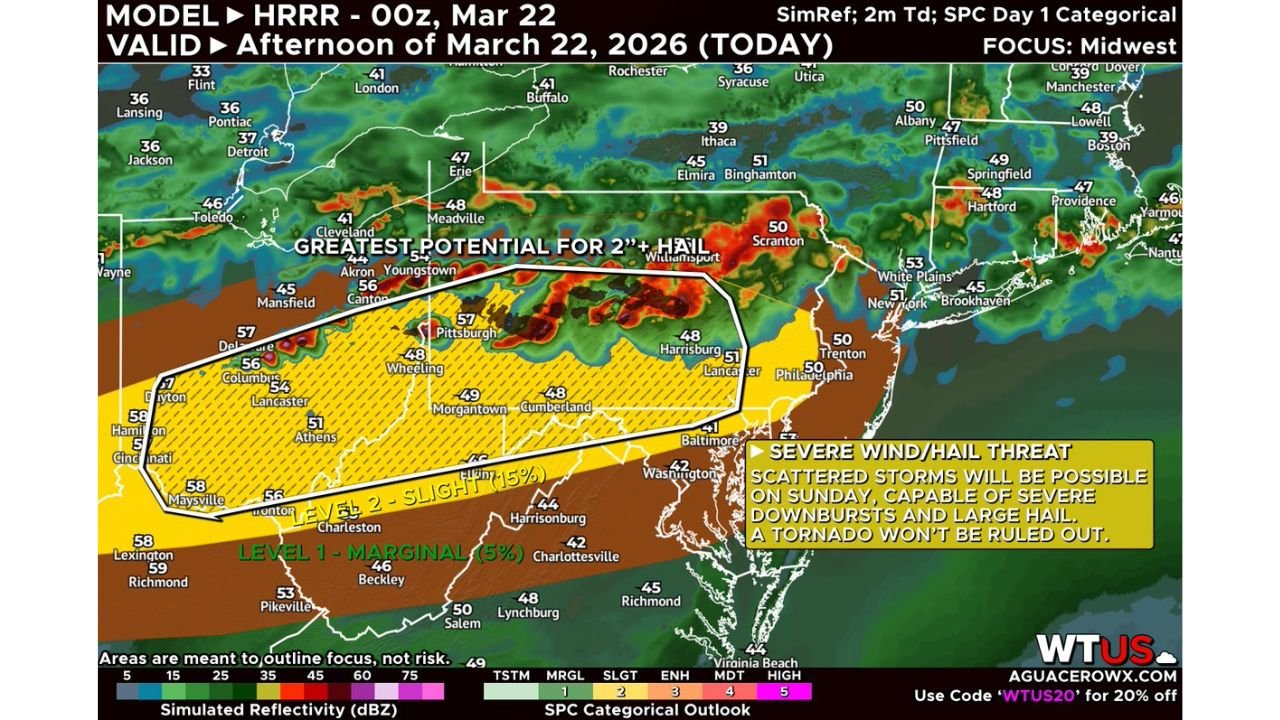
PITTSBURGH, PENNSYLVANIA — A fairly robust hail threat is taking shape across parts of the Midwest and Mid-Atlantic, with a corridor from central Ohio through western Pennsylvania into West Virginia and western Maryland highlighted for the greatest potential of 2-inch or larger hailstones Sunday afternoon and evening.
High-resolution model guidance indicates that supercells and storm clusters are likely to develop by mid to late afternoon, capable of producing large to very large hail and intense downbursts. While hail and damaging winds are the primary concerns, forecasters caution that a tornado or two cannot be ruled out.
Greatest 2”+ Hail Potential from Columbus to Pittsburgh
The most concerning zone stretches from Columbus and Lancaster, Ohio, eastward through Wheeling, Morgantown, and Pittsburgh, and into parts of central Pennsylvania including Harrisburg and near Scranton.
Within this corridor, atmospheric conditions appear favorable for strong rotating updrafts — a key ingredient for producing hailstones exceeding 2 inches in diameter.
Cities under the greatest hail potential include:
- Columbus, Ohio
- Pittsburgh, Pennsylvania
- Wheeling, West Virginia
- Morgantown, West Virginia
- Harrisburg, Pennsylvania
Large hail is most likely during the earlier, more discrete phase of storm development before storms consolidate into clusters or lines.
Level 2 Slight Risk Across the Region
The Storm Prediction Center categorical outlook places much of this area under a Level 2 (Slight) risk, indicating scattered severe storms are possible, some of which could be intense.
South of the primary hail corridor — including portions of West Virginia, eastern Kentucky, and western Virginia — a Level 1 (Marginal) risk is in place, where isolated severe storms may develop.
Damaging Downbursts Also Possible
As storms evolve later in the afternoon and evening, clusters may produce intense downbursts, leading to damaging straight-line winds.
The transition from discrete supercells to organized clusters could expand the wind threat eastward toward Baltimore, Washington, and surrounding Mid-Atlantic communities, though the highest hail potential remains farther west.
Tornado Risk Low but Not Zero
While the main focus is on hail and wind, forecasters note that a tornado or two cannot be ruled out, particularly if any storms remain isolated long enough to maintain strong low-level rotation.
Localized spin-ups would most likely occur within the Slight Risk zone across Ohio, western Pennsylvania, and northern West Virginia.
Afternoon and Evening Timing Critical
Storm initiation is expected by mid to late afternoon, with activity intensifying into the early evening hours.
Residents across Columbus, Pittsburgh, Morgantown, Harrisburg, and surrounding areas should prepare for rapidly developing storms capable of producing severe hail in a short period of time.
Vehicles, outdoor property, and roofing materials are particularly vulnerable when hailstones reach or exceed 2 inches in diameter.
As the Midwest and Mid-Atlantic prepare for a potentially active severe weather day, residents are urged to monitor forecasts closely and have multiple ways to receive warnings.
For continued national severe weather coverage and real-time updates, stay with ChicagoMusicGuide.com.