Thursday Severe Weather Threat in Iowa, Illinois and Missouri Faces a Critical Complication as Early Morning Storms Erode the Warm Sector That Afternoon Supercells Need to Develop
DES MOINES, IA — It is the scenario that experienced Midwest storm chasers and forecasters dread most — a setup that had all the ingredients for a significant severe weather day, now being quietly undermined before most people have even had their morning coffee. Early morning thunderstorm activity on Thursday is carving directly into the warm sector across Iowa, Illinois, and Missouri, and the latest model data raises a legitimate question about whether the afternoon severe weather threat can deliver on what the atmospheric setup originally promised.
The problem is not the storm system itself. The problem is timing — and in Midwest severe weather, timing can be everything.
What a Warm Sector Is and Why Losing It Matters
To understand why this development is significant, it helps to understand what the warm sector actually does. In a classic severe weather setup, the warm sector is the corridor of warm, moisture-rich air that sits ahead of an advancing cold front. It acts as the engine room of the entire severe weather event — it is where CAPE (Convective Available Potential Energy), the explosive fuel that powers violent thunderstorm updrafts, builds to its highest values during the afternoon heating hours.
When overnight or early morning thunderstorms fire ahead of schedule, they do not just produce rain and lightning — they dump large volumes of cold outflow air across the warm sector like pouring ice water into a fire. That cold air stabilizes the atmosphere, effectively capping the fuel supply that afternoon supercells would otherwise tap into. Forecasters call this process warm sector erosion, and it is one of the most common reasons that high-potential Midwest severe weather days fail to produce the organized storm activity the morning setup suggested was possible.
Current analysis indicates that is exactly what is happening across Iowa, northern Missouri, and Illinois on Thursday morning.
What the Data Is Showing
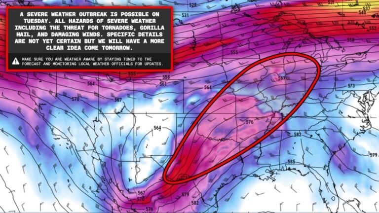
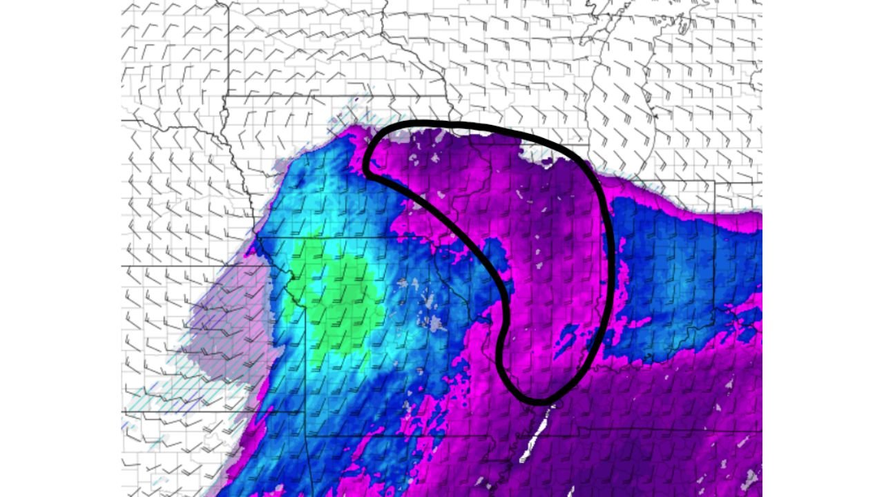
The latest model run, valid through the morning hours, shows a clearly defined area where early convection has already taken a significant bite out of the warm sector across the Iowa and northern Missouri corridor. The boundary between the stabilized, storm-chewed air to the northwest and the still-intact warm sector to the southeast is visible in the moisture and instability field — a curved intrusion of cooler, drier air pushing into a region that was supposed to remain primed for afternoon storm development.
The hand-drawn analysis on the map outlines this compromised zone directly. Inside that boundary, the atmosphere has been partially stabilized by morning storm outflow. Outside it — across southern Missouri, southern Illinois, Indiana, and Kentucky — the warm sector remains largely intact, and the potential for organized severe weather during the afternoon hours is better preserved.
The cold front itself, which will be the primary forcing mechanism pushing storms eastward through the afternoon, is not expected to be sufficient on its own to overcome the stabilized air in the northern corridor. Storm track data suggests the most productive severe weather environment Thursday will be anchored to wherever the low-pressure center tracks — because low pressure systems can generate enough lift to punch through a stabilized boundary layer in ways that a cold front alone cannot.
The Thursday Setup: What Still Works and What Does Not
| Factor | Status | Impact on Severe Weather |
|---|---|---|
| Warm Sector (Northern Zone) | Partially Eroded | Reduces afternoon supercell potential |
| Warm Sector (Southern Zone) | Largely Intact | Best remaining severe weather corridor |
| Cold Front Forcing | Moderate | Insufficient alone to overcome stabilization |
| Low-Pressure Center | Primary Hope | Best lift source for afternoon development |
| Morning Convection | Active/Ongoing | Continuing to erode northern warm sector |
| Afternoon Heating Window | Uncertain | Depends on cloud cover from morning storms |
| Overall Setup Ceiling | Lowered | High-end day now less likely in northern zones |
State-by-State Assessment for Thursday
🔴 Missouri (Southern) and Illinois (Southern) — Best remaining severe weather potential on Thursday. The warm sector across the southern portions of both states is more intact than the north, and storm development along and ahead of the low-pressure track could still produce organized severe weather during the afternoon and evening hours. Damaging winds, large hail, and an isolated tornado remain possible here.
🟠 Iowa (Southern Fringe) and Missouri (Central) — Elevated but reduced risk compared to earlier outlooks. The warm sector erosion is most pronounced across the northern tier. Some recovery is possible if morning storm activity diminishes and afternoon heating can partially rebuild instability, but this is the zone most affected by the setup complication. Current analysis suggests the severe weather potential here is notably lower than it appeared 24 hours ago.
🟠 Indiana and Kentucky (Western) — Elevated risk. The intact warm sector to the southeast keeps these states in play for Thursday afternoon severe weather, particularly if the low-pressure track pushes organized activity eastward into the afternoon hours. Damaging winds and large hail are the primary threats.
🟡 Illinois (Northern) and Iowa (Central and Northern) — Marginal risk. This is the zone most directly impacted by the warm sector erosion. While isolated strong storms are possible, the stabilized atmosphere significantly limits the potential for organized severe weather development Thursday afternoon.
🟡 Wisconsin (Southern) and Nebraska (Eastern) — Marginal risk. The outer edges of the storm system may produce strong thunderstorms, but the severe weather environment here is limited and dependent on how aggressively the low pressure lifts northward.
🟢 Minnesota, Michigan, Ohio — Low risk for Thursday. These states are outside the primary corridor for organized storm development.
Forecast Confidence
Forecast Confidence: Low to Moderate — and Intentionally So. This is one of those forecast situations where intellectual honesty matters more than projecting false certainty. The warm sector erosion visible in the morning data introduces genuine uncertainty that was not present in the 24-hour outlook. Setups where early convection chews into the warm sector before afternoon heating can take over have a well-documented history of underperforming compared to their morning potential.
That does not mean the threat disappears entirely. The low-pressure center remains the wild card — if it tracks favorably and generates enough lift to work with whatever instability survives the morning, organized severe weather is still possible across southern Missouri, southern Illinois, and Indiana during the afternoon hours. Storm chasers and meteorologists tracking this event will be watching the 10 AM surface analysis closely to gauge how much of the warm sector has survived and whether afternoon recovery is realistic.
Residents across the affected states should maintain weather awareness Thursday but understand that this is a conditional and uncertain setup — one where the atmosphere has already thrown a significant complication into the forecast.
More severe weather pattern analysis is always on the horizon. Stay informed at ChicagoMusicGuide.com — your source for Midwest storm tracking, tornado outlooks, and severe weather analysis across Iowa, Illinois, Missouri, and the entire United States.