Illinois, Indiana, and Michigan See Late Night Storms Push Southeast From Chicago With Lingering Strong Storm Threat Into Overnight Hours
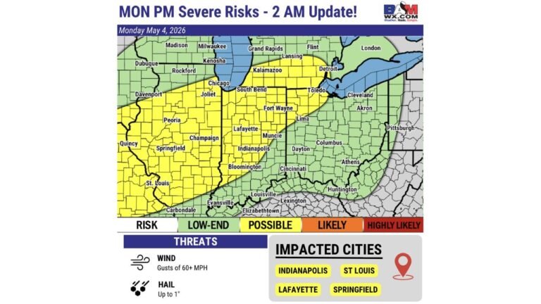
ILLINOIS, INDIANA, MICHIGAN — A line of strong thunderstorms is pushing southeast from the Chicago area late this evening, with storms extending from Milwaukee through Chicago down toward Peoria and St. Louis, and continuing into parts of Indiana and Michigan. Current radar trends show the system gradually weakening, but a few stronger storms are still expected to persist into the overnight hours.
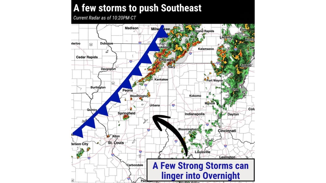
Storm Line Moves From Chicago Toward Indiana and Michigan
Radar imagery shows a well-defined line of storms stretching across northeastern Illinois, including Chicago, Waukegan, and Gary, and trailing southwest through Peoria, Bloomington, and Springfield toward St. Louis.
As this line advances, storms are beginning to push southeast into Indiana, impacting areas such as Kankakee, Kokomo, Indianapolis, and Bloomington, while additional storm clusters remain active across western Michigan, including Grand Rapids, Kalamazoo, and Lansing.
This movement indicates a continued progression of storms into the Midwest corridor, with the system following a typical southeast track along a frontal boundary.
Storms Gradually Weakening but Not Fully Dissipating
While the overall trend suggests gradual weakening and slowing of the main storm line, conditions remain supportive enough for isolated strong storms to continue, especially in areas downstream of the current activity.
The weakening trend is a positive sign, reducing the likelihood of widespread severe impacts. However, embedded cells within the line could still produce brief bursts of heavy rain, gusty winds, and localized lightning activity.
Areas across central and eastern Illinois into Indiana should remain alert as the line continues to evolve through the night.
Overnight Risk Focused Across Indiana and Southern Michigan
As storms continue moving southeast, the focus shifts toward Indiana and southern Michigan, where lingering storm activity is expected into the overnight hours.
Cities including Indianapolis, Fort Wayne, South Bend, and Detroit may see scattered showers and storms, with a few cells maintaining enough strength to produce locally strong wind gusts.
Meanwhile, parts of southern Michigan, including Kalamazoo and Grand Rapids, could continue to experience ongoing storm activity as the system slowly pushes through.
Localized Heavy Rain and Gusty Winds Still Possible
Even as the storm line weakens, it still carries the potential for localized impacts, particularly where storms briefly intensify.
Rainfall could become moderate to heavy at times, especially in areas where storms train over the same locations. Additionally, gusty winds may accompany stronger cells, creating brief but noticeable impacts.
Drivers and overnight travelers across Illinois, Indiana, and Michigan should remain cautious, particularly in areas experiencing reduced visibility or wet road conditions.
What to Expect as the System Continues Overnight
The overall trend suggests that storms will continue to weaken gradually overnight, with activity becoming more scattered and less intense as it moves farther southeast.
However, the presence of lingering instability means that a few stronger storms cannot be ruled out, especially during the early overnight hours before conditions stabilize further.
Residents across the region should continue monitoring updates, especially in areas where storms are still active or approaching.
As storms track across Illinois, Indiana, and Michigan tonight, staying aware of changing conditions is important. For continued storm tracking, weather alerts, and regional updates, visit ChicagoMusicGuide.com.