Texas Oklahoma Kansas To Chicago And Milwaukee Face Conditional Severe Storm Threat With Tornado Risk And Large Hail Potential April 12 Through April 14
UNITED STATES — A complex and highly conditional severe weather pattern is setting up across the central and southern Plains into the Midwest, with cities including Dallas, Oklahoma City, Wichita, Kansas City, Chicago, and Milwaukee potentially facing isolated but intense thunderstorms between April 12 and April 14.
Storm Setup Builds From Texas To Midwest With Uncertain Triggers
The atmosphere across Texas, Oklahoma, and Kansas is expected to become increasingly unstable, with strong instability (storm fuel) and wind shear (spin) in place—two critical ingredients for severe weather development.
However, despite these favorable conditions, a major limiting factor remains: weak large-scale forcing. This means that while the environment is primed for storms, there may not be enough triggers to initiate widespread thunderstorm activity.
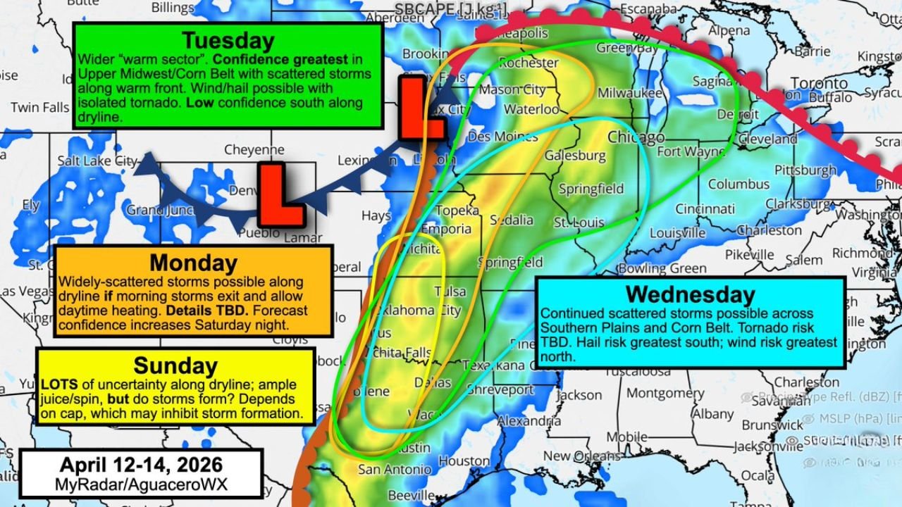
Cities like Dallas, Wichita Falls, Oklahoma City, and Tulsa sit directly in this volatile zone where storms may struggle to form—but could become severe quickly if they do.
Capping Layer May Suppress Storms But Raise Risk Of Explosive Development
A key feature of this setup is the presence of a strong “cap”, or a layer of warm, dry air located above the surface. This cap acts like a lid, preventing storms from forming in most areas.
In many locations across the central and southern Plains, this cap is expected to hold firm, leading to mostly quiet weather conditions despite high instability.
However, if this cap weakens even slightly—especially during Sunday into Monday—it could allow isolated supercells to rapidly develop. These storms would have access to a high-end environment capable of producing:
- Large hail, potentially baseball-sized
- Isolated tornadoes
- Damaging wind gusts
This creates an “all-or-nothing” scenario, where 90% of the region may see little activity, but the remaining 10% could experience significant severe weather impacts.
Severe Weather Risk Shifts Toward Midwest By Tuesday
As a warm front lifts northward, the focus for more organized storm activity is expected to shift into the Corn Belt and Upper Midwest by Tuesday.
Cities including Des Moines, Cedar Rapids, Waterloo, Chicago, Milwaukee, and Springfield are more likely to see scattered thunderstorms along this boundary.
In this region, confidence is higher for storm development, with risks including:
- Damaging winds
- Large hail
- A few isolated tornadoes
Unlike the Plains, where storm formation is uncertain, the Midwest setup offers better forcing mechanisms, increasing the likelihood of widespread storm coverage.
Wednesday Extends Risk Across Southern Plains And Midwest
By Wednesday, the storm threat expands across a broader corridor from the southern Plains into the Midwest, impacting cities like Kansas City, St. Louis, Tulsa, Little Rock, and Louisville.
Storms during this phase may remain scattered, but hazards will vary by region:
- Tornado risk remains uncertain but possible
- Hail threat is expected to be higher in southern areas
- Damaging winds could become more prominent farther north
Forecast confidence for exact storm placement and timing remains low to moderate, as small-scale atmospheric features will play a critical role in determining where storms actually develop.
Why This Severe Weather Pattern Is Difficult To Predict
One of the biggest challenges with this setup is its reliance on mesoscale features—small-scale atmospheric processes that cannot be fully predicted until hours before storms form.
Weather models often struggle in these scenarios, meaning:
- Storm development may not be clear until the night before or same day
- Some areas may remain completely dry despite high risk indicators
- Others could see sudden, intense severe storms with little warning
This makes it essential for residents across Texas, Oklahoma, Kansas, and the Midwest to stay alert for rapid forecast updates.
What Residents Across Affected States Should Watch For
From Dallas and Oklahoma City to Chicago and Milwaukee, residents should be aware of:
- Rapidly changing storm forecasts
- Localized severe weather risks despite overall quiet conditions
- The potential for isolated but dangerous thunderstorms
- Updates issued close to storm development time
Even though many areas may not see storms, those that do could experience high-impact severe weather in a short time window.
For continued updates on severe weather risks, storm tracking, and regional forecasts, visit ChicagoMusicGuide.com and stay informed as this dynamic weather pattern evolves.