Dallas Oklahoma City Tulsa Wichita Kansas City St Louis Des Moines And Chicago Face Another Round Of Severe Storms Wednesday With Tornado And Hail Threats Returning
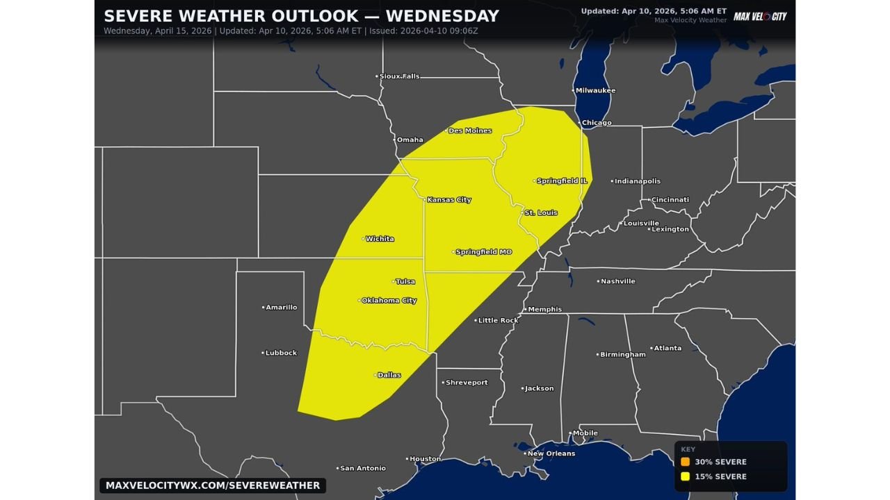
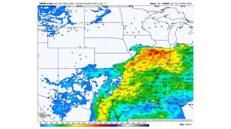
UNITED STATES — A continuing active severe weather pattern is set to bring another round of dangerous thunderstorms on Wednesday, stretching from Dallas and Oklahoma City through Tulsa, Wichita, Kansas City, St. Louis, Des Moines, and into Chicago as the storm system reloads across the Plains and Midwest.
Storm Corridor Expands From Texas To Illinois With Multiple Hazards
The latest outlook shows a broad zone of severe weather potential covering much of the central Plains into the Midwest, with key cities like Dallas, Tulsa, Wichita, Kansas City, and Chicago directly in the path.
Storms are expected to develop along this corridor and move northeast, bringing threats that include:
- Large hail capable of causing damage to vehicles and property
- Strong to damaging wind gusts
- A few isolated tornadoes embedded within stronger storms
While this may not be the most intense day of the overall pattern, the concern is increasing due to repeated rounds of storms impacting the same regions over multiple days.
Chicago And Midwest Cities Brace For Incoming Storm Activity
As storms track northeast, cities across the Midwest—including St. Louis, Springfield, Des Moines, and Chicago—are expected to see increasing storm coverage by late Wednesday into the evening hours.
The environment across this region remains favorable for organized thunderstorm clusters, with enough instability and wind energy to support severe weather development.
For Chicago and surrounding areas, the primary concerns will be:
- Damaging winds from fast-moving storm lines
- Periods of heavy rainfall reducing visibility and causing localized flooding
- An isolated tornado risk, especially with any discrete storms ahead of the main line
Storm Fatigue Builds As Pattern Remains Active
One of the biggest concerns with this setup is not just a single event—but the cumulative impact of repeated storm days. Even if Wednesday’s storms are not the most explosive, ongoing activity increases the risk of damage and disruption.
Communities from Texas through Missouri and into Illinois may already be dealing with prior storms, making them more vulnerable to:
- Tree damage and power outages
- Saturated ground increasing wind damage potential
- Reduced response time due to back-to-back weather events
This “storm train” effect means impacts can quickly add up, even with moderate storm intensity.
Why This Pattern Keeps Reloading Across The Plains And Midwest
The ongoing severe weather setup is driven by a persistent atmospheric pattern that continues to funnel warm, moist air from the Gulf of Mexico into the Plains, while disturbances move in from the west.
This combination allows the atmosphere to reset and recharge daily, leading to:
- New rounds of thunderstorm development each day
- Shifting storm zones from the southern Plains to the Midwest
- Uncertainty in exact timing and placement of the strongest storms
Because of this, forecasts may continue to evolve, and residents should stay alert for updates.
What Residents From Dallas To Chicago Should Watch Closely
From Dallas and Oklahoma City to Chicago and Milwaukee, residents should prepare for:
- Rapidly developing storms during the afternoon and evening
- Warnings for severe thunderstorms or tornadoes issued with short lead times
- Changing weather conditions as storms move quickly northeast
Even areas that avoid the strongest storms could still see gusty winds, lightning, and brief heavy rain.
Staying weather-aware will be critical as this multi-day severe weather pattern continues to unfold across the central United States.
For ongoing updates, storm coverage, and detailed forecasts affecting major cities and regional events, visit ChicagoMusicGuide.com and stay informed as this active weather pattern continues.