Dixie Alley and the Ohio Valley Face Damaging Winds and Tornadoes Monday as the Mid-South Breaks Its Long Quiet Stretch
NASHVILLE, TN — For the first time in a long time, Dixie Alley and the Ohio Valley are staring down a legitimate severe weather day — and the outlook for Monday, April 27, 2026 is drawing serious attention from forecasters who have watched this region stay relatively quiet while the Midwest and Plains absorbed outbreak after outbreak through early spring.
That quiet ends Monday. Damaging winds and tornadoes are the primary concerns across a broad corridor covering St. Louis, Louisville, Nashville, Memphis, Little Rock, Jackson, and Birmingham — a zone that sits at the heart of Dixie Alley, one of the most historically tornado-prone regions in the entire United States.
What the Monday Outlook Shows
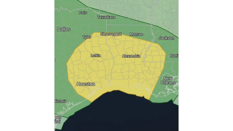
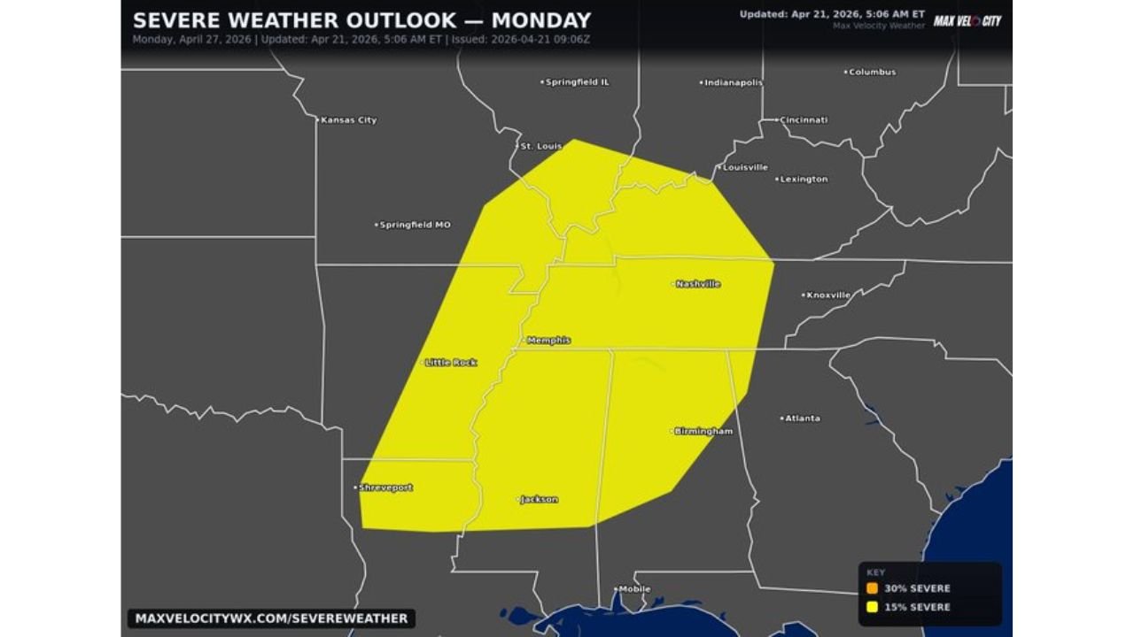
The severe weather outlook map issued April 21, 2026 shows a 15% severe weather probability zone — shown in yellow — covering a large swath of the mid-South and Ohio Valley for Monday, April 27. This zone encompasses one of the most populated and tornado-vulnerable corridors in the country, stretching from St. Louis southward through Memphis and Little Rock and into Jackson, Mississippi and Birmingham, Alabama, while simultaneously reaching northeastward through Louisville, Lexington, and toward Cincinnati.
The 15% severe probability zone is a meaningful designation for a six-day outlook — it reflects forecaster confidence that organized severe weather will impact this region Monday even at this lead time. When that signal appears this far in advance over Dixie Alley, experienced meteorologists pay close attention.
Damaging winds and tornadoes are explicitly identified as the two main concerns for Monday’s event. This threat combination is the signature of an organized storm system with strong wind shear and sufficient instability to support rotating thunderstorms — exactly the setup that Dixie Alley has historically produced its most significant tornado events from.
Monday Severe Weather Probability Summary
| Zone | Probability | Key Cities |
|---|---|---|
| Yellow — 15% Severe | Slight Risk level | St. Louis, Louisville, Nashville, Memphis, Little Rock, Jackson, Birmingham |
| Outside Zone | Below threshold | Kansas City, Atlanta, Knoxville, Indianapolis, Columbus |
State-by-State Breakdown
Tennessee — Nashville and Memphis Both of Tennessee’s largest cities fall squarely inside Monday’s severe weather zone. Nashville sits near the northeastern edge of the risk corridor where the overlap between the Ohio Valley and mid-South storm tracks converges. Memphis is positioned in the western portion of the zone where the storm system will be most mature and organized. Damaging winds and tornadoes are both credible threats for Tennessee on Monday.
Kentucky — Louisville and Lexington Louisville and Lexington fall inside the northern portion of Monday’s risk zone. The Ohio Valley corridor through Kentucky has been largely bypassed by significant severe weather for an extended period, making Monday’s setup a notable change in the pattern. Damaging winds are the primary concern across Kentucky, with tornadoes possible particularly along and south of the warm front boundary expected to be draped across the state Monday.
Missouri — St. Louis St. Louis sits at the northwestern corner of Monday’s risk zone. Storm systems organizing to the south and southwest will track toward St. Louis through Monday afternoon and evening. Damaging winds and large hail are the primary threats for the St. Louis metro.
Arkansas — Little Rock Little Rock and central Arkansas fall inside the core of the risk zone for Monday. Arkansas has been identified as a focus area for the late April severe weather pattern breaking the region’s extended quiet stretch — and Monday represents one of the better setups the state will see this week. Tornadoes and damaging winds are both real concerns across Arkansas Monday.
Mississippi — Jackson Jackson falls at the southern end of Monday’s risk corridor. The storm system pushing through Dixie Alley Monday will reach Mississippi and the lower mid-South during the afternoon and evening hours. Damaging winds and an isolated tornado are possible across central Mississippi.
Alabama — Birmingham Birmingham sits on the eastern edge of Monday’s risk zone. Alabama falls within the Dixie Alley corridor where tornado events can occur with any organized severe weather system. The Birmingham metro should be weather-aware Monday with the same damaging wind and tornado threat profile as the broader mid-South corridor.
Illinois — Springfield Springfield, Illinois sits just outside the northern fringe of Monday’s primary risk zone. The storm system may clip the southern Illinois corridor, and residents near Springfield should monitor whether the risk zone expands northward as Monday’s setup comes into clearer focus through midweek model runs.
Why Monday Matters for This Region
Dixie Alley — the tornado-prone corridor covering Arkansas, Tennessee, Mississippi, Alabama, and surrounding states — historically produces some of the deadliest tornado events in the United States due to the region’s combination of dense forest terrain, nighttime storm activity, mobile home concentrations, and population centers that sit in low-lying river valleys. When a legitimate severe weather signal appears over this corridor after an extended quiet period, the combination of atmospheric priming and potential resident complacency makes preparation especially important.
Current analysis indicates Monday’s event represents the first legitimate organized severe weather threat to the Ohio Valley and Dixie Alley corridor in a meaningful stretch of time. The region’s population is not in a heightened state of weather awareness after weeks of quiet — which makes the urgency of preparation ahead of Monday all the more critical.
Forecast Confidence
Confidence: Low to Moderate for the overall pattern and geographic placement of Monday’s risk zone. The six-day lead time on this outlook means details will evolve considerably through Wednesday and Thursday as the system approaches and short-range models bring the storm track, timing, and intensity into sharper focus. What is consistent across current guidance is the geographic target — St. Louis through Nashville and Memphis into Little Rock, Jackson, and Birmingham — and the primary threats of damaging winds and tornadoes.
Residents across all identified cities should begin monitoring forecast updates daily through the weekend and have shelter plans confirmed before Monday afternoon.
More Dixie Alley and Ohio Valley severe weather coverage is always on the horizon. Stay informed at ChicagoMusicGuide.com — your source for tornado and damaging wind tracking across Tennessee, Arkansas, Kentucky, Mississippi, and the entire United States.