Morning Rain Across Central Illinois Could Be the One Factor That Limits Monday Severe Weather as Atmospheric Recovery Becomes the Key Question
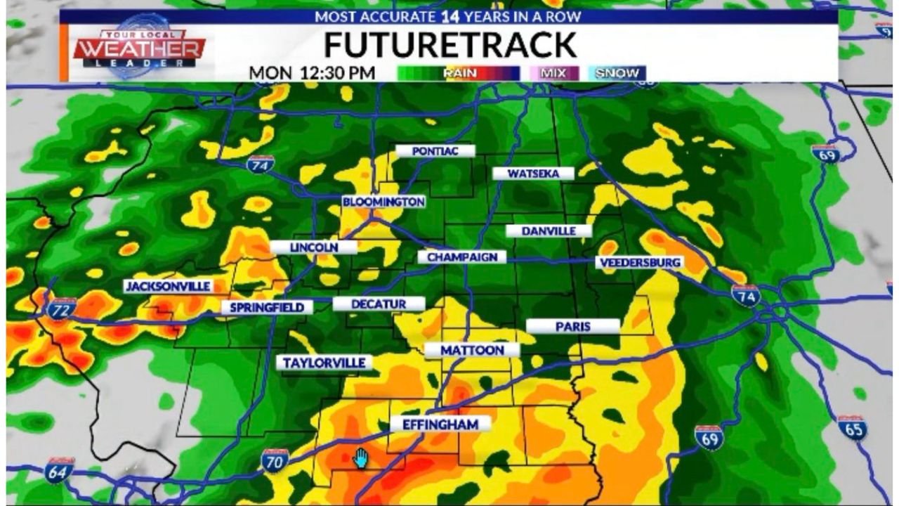
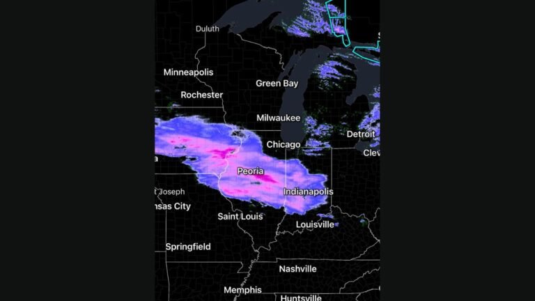
SPRINGFIELD, IL — There may be a saving grace buried inside Monday’s dangerous severe weather setup — and it comes from the very storms that are already falling. Forecast radar data valid for Monday at 12:30 PM CDT shows a widespread shield of rain and storm activity blanketing central Illinois, covering communities from Jacksonville and Springfield eastward through Decatur, Champaign, Bloomington, and into Danville and Veedersburg. This is not the severe weather event itself. This is the morning rain that could determine whether the afternoon severe weather event reaches its highest possible potential — or gets partially throttled before it ever gets started.
The atmosphere has a finite amount of energy to work with on any given day. When morning rain consumes that energy early, less of it is available for the dangerous rotating supercells expected later. How quickly and how completely the atmosphere recovers after that morning rain clears is now the single most important forecasting question remaining for Monday, April 27, 2026 across central and southern Illinois.
What the 12:30 PM Forecast Radar Is Showing
Futuretrack data for Monday midday paints a clear picture of the challenge. A broad, disorganized rain mass — shown in greens, yellows, and isolated orange cores — is draped across the heart of central Illinois at the critical pre-storm window. The coverage is not trivial. Rain is shown from Jacksonville in the west through Springfield, Taylorville, Effingham, Mattoon, Paris, and Champaign — essentially the entire central corridor of the state is wet at noon.
The orange and red cores near Springfield, Taylorville, and the Effingham area indicate pockets of heavier rainfall within the broader rain shield, not severe thunderstorms. But heavy rain at midday in these locations means the ground is saturated, the atmosphere is being worked over, and the critical destabilization process that severe storms need is being delayed or disrupted.
The yellow and green rain coverage extending northward toward Bloomington, Pontiac, and Watseka shows the rain shield reaching well into the northern fringe of the primary severe weather risk zone as well.
The Atmospheric Recovery Question
The core forecasting debate for Monday now comes down to a single variable: how fast will the atmosphere recover after the morning rain exits?
When a rain mass moves through a region, it cools the surface, saturates the soil, increases cloud cover, and consumes the convective energy — the atmospheric fuel — that afternoon severe thunderstorms depend on. Once the rain exits, the sun needs to heat the surface back up, dry out the lowest layers of the atmosphere, and rebuild the instability that was depleted. This process takes time. The faster it happens, the more dangerous the afternoon severe weather window becomes. The slower it happens, the more the overall threat is suppressed.
Current analysis indicates this recovery question is unresolved as of Sunday evening. There is meaningful uncertainty in how quickly central Illinois can rebuild its instability after what is showing up as a substantial midday rain shield. If recovery is fast and the atmosphere fully recharges by 2:00 or 3:00 PM, the large tornado and significant hail threat discussed in previous analysis remains fully intact. If recovery is slow or incomplete, the most dangerous storm scenarios — long-track tornadoes, EF-2 and stronger — become less likely, and the event trends toward a more wind-driven squall line outcome.
What This Means Community by Community
Springfield and Sangamon County — Sitting directly under the midday rain shield. Surface heating will be suppressed through the noon hour. Severe weather potential in the afternoon depends entirely on how fast skies clear and instability rebuilds. Still within the tornado risk zone regardless — this data does not eliminate the threat, it introduces uncertainty.
Decatur and Macon County — Similar situation to Springfield. Heavy midday rain shown in current futuretrack data. Atmospheric recovery timing is critical for determining afternoon severe weather intensity here.
Champaign-Urbana and east-central Illinois — Rain coverage shown through the Champaign corridor at midday. The eastern fringe of Illinois may actually see faster clearing than the western areas, which could make this corridor an important zone to watch for afternoon storm development once the morning rain moves through.
Effingham and south-central Illinois — The southernmost communities shown with midday rain coverage. Effingham, Mattoon, and Paris all sit in the rain shield at noon. Farther south, where the rain coverage may be lighter or exit earlier, recovery could be faster and the severe weather threat more robust.
Bloomington, Pontiac and north-central Illinois — On the northern fringe of the rain shield. Less heavy coverage here compared to the Springfield corridor. If the warm front stabilizes north of this area as expected, these communities transition to the primarily wind-driven threat scenario discussed in previous analysis.
The High-End Scenario vs. the Suppressed Scenario
| Scenario | Condition | Outcome |
|---|---|---|
| Fast Recovery | Morning rain exits by noon, sun heats surface quickly | Large tornadoes and significant hail — full severe weather threat realized |
| Slow Recovery | Rain lingers into early afternoon, instability suppressed | Squall line with damaging winds — tornado threat reduced but not zero |
| Partial Recovery | Clearing in south, clouds persist in north | Split event — south IL sees severe supercells, north IL sees wind-driven line |
| Current Forecast Lean | Uncertain — monitoring ongoing | Southern IL still primary tornado zone regardless of scenario |
Forecast Confidence
Overall confidence in the Monday severe weather event remains intact. What this morning rain data introduces is uncertainty in the ceiling of the event — not whether severe weather occurs, but how extreme the worst outcomes could be. Confidence that southern Illinois south of the Springfield-Effingham corridor produces significant severe weather including tornadoes is MODERATE to HIGH even accounting for the morning rain complication, as recovery is expected to be faster farther south where the rain coverage is lighter. Confidence in the highest-end outcomes — multiple long-track EF-3 tornadoes — is MODERATE and conditional on how quickly the atmosphere recovers. This forecast will continue to evolve through Monday morning as the rain shield moves and clearing begins.
The alarm bells are not ringing yet. But they are sitting right there on the table. Watch the skies Monday morning. Watch how fast the clouds break. That will tell the story of the afternoon.
More severe weather coverage is always on the horizon. Stay informed at ChicagoMusicGuide.com — your source for real-time storm tracking, hour-by-hour forecast updates, and breaking severe weather coverage across Illinois and the entire United States.