High-Resolution Tornado Probability Tool Prints a Massive 15% Risk Corridor Over Illinois and Indiana Pointing Toward a Likely Outlook Upgrade on Monday
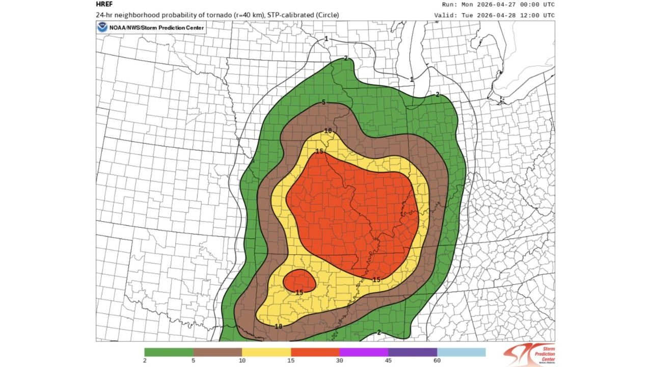
SPRINGFIELD, IL — The data just got harder to ignore. The latest run of one of the most sophisticated tornado probability tools used by the Storm Prediction Center has printed a sweeping and expansive 15% tornado probability corridor valid through Tuesday, April 28, 2026 at 12:00 PM UTC — and the geographic footprint of that risk zone is striking. It covers an enormous swath of Illinois, Indiana, and surrounding states, with an inner core pushing well above 30% and 45% tornado probability across the heart of the Midwest.
This is not a background tool. The Storm Prediction Center actively uses this data when constructing official severe weather outlooks. And current analysis indicates that at minimum, a 15% tornado corridor should appear in the next official outlook update — with the potential for something larger depending on how the morning convection situation resolves across Illinois.
What the Probability Tool Is Showing
The HREF — which stands for High-Resolution Ensemble Framework, a collection of multiple high-detail models blended together to produce calibrated probability estimates — is one of the most reliable short-range severe weather probability tools available to operational forecasters. Its STP-calibrated tornado probability output, shown here on a 40-kilometer neighborhood radius, is specifically tuned using the Significant Tornado Parameter — a composite index combining instability, wind shear, and low-level rotation — to produce statistically meaningful tornado probabilities.
The current run, initialized Monday April 27 at 00:00 UTC, shows the following probability structure across the Midwest:
The deep orange and red core — representing 30% to 45%+ tornado probability — is centered across a broad zone covering central and southern Illinois and extending into western and central Indiana. This is an exceptionally large footprint for a 30%+ tornado probability zone. Surrounding that core is the 15% probability zone shown in yellow, which expands the significant tornado risk across an even wider corridor encompassing much of Illinois, Indiana, western Kentucky, and portions of adjacent states. The 10% zone in tan and the 5% zone in brown push the outer tornado threat boundary into Iowa, Wisconsin, Michigan, Ohio, and Tennessee.
A separate secondary 15% probability bullseye is visible in the southern portion of the map, isolated below the main risk zone, indicating a distinct secondary area of tornado concern farther south — likely tied to storm activity across the Missouri-Arkansas border region.
Why This Tool Matters for the Official Outlook
The Storm Prediction Center’s operational forecasters directly reference HREF STP-calibrated output when building official Day 1 convective outlooks. When this tool produces a 15% tornado corridor of this geographic size, it creates a strong statistical argument for the official outlook to reflect at least that same threshold — and potentially higher if the forecasters’ subjective analysis of the atmospheric setup supports it.
Current analysis suggests the next official outlook update should include at minimum a 15% tornado probability corridor covering the Illinois-Indiana corridor. Whether that corridor expands to reflect the 30% and 45% inner zone values shown in the HREF output depends on how confident forecasters become in the afternoon atmospheric recovery question that has been the central wildcard of this entire Monday setup.
The morning convection complication — widespread rain across central Illinois through midday — is the one factor holding back full commitment to the highest probability tier in the official outlook. If subsequent model guidance shows faster clearing and stronger instability recovery, an upgrade to reflect the 30%+ inner zone becomes increasingly probable.
Probability Zone Breakdown Table
| Probability Zone | Color | Geographic Coverage | Significance |
|---|---|---|---|
| 45%+ | Deep Red Core | Central IL, western IN | Extremely high tornado probability — major outbreak level |
| 30% | Orange | Broader IL, IN corridor | High — multiple tornadoes likely in zone |
| 15% (Main) | Yellow | IL, IN, western KY, MO fringe | Significant — official outlook upgrade expected |
| 15% (Secondary) | Yellow isolated south | MO-AR border region | Separate secondary tornado area |
| 10% | Tan | Iowa, Wisconsin, Michigan fringe | Elevated — tornado-warned storms possible |
| 5% | Brown | Ohio, Tennessee, broader Midwest | General tornado threat |
| 2% | Green | Outer boundary — broad reach | Background tornado awareness zone |
State-by-State Impact Based on Probability Data
Illinois — The centerpiece of the entire probability map. The 30% to 45% core zone is planted directly over central and southern Illinois. Communities including Springfield, Decatur, Champaign, Effingham, Carbondale, and Bloomington all sit within or adjacent to the highest-probability corridor. This is the state where the tornado risk is most concentrated and most statistically significant on Monday.
Indiana — Shares the high-probability core with Illinois. Terre Haute, Indianapolis, Bloomington, Lafayette, and Evansville all fall within the 30%+ zone. The HREF data places Indiana as a co-equal risk state with Illinois for Monday’s tornado threat, which is consistent with what high-resolution model storm track data has been showing across multiple runs.
Kentucky — Western Kentucky including the Paducah and Owensboro corridors falls within the 15% zone. Tornado-warned storms pushing northeast out of Illinois will impact this area during the evening and overnight hours.
Missouri — The secondary 15% probability bullseye visible in the southern portion of the map affects portions of southern Missouri and the Missouri-Arkansas border region. This represents a separate and distinct tornado threat area tied to storm activity south of the main Illinois-Indiana corridor.
Wisconsin and Michigan — The outer 10% zone clips the southern portions of both states. Brief tornado-warned storms are possible, particularly from fast-moving squall line segments pushing northeast through the evening.
Iowa and Ohio — Within the 5% to 10% outer probability rings. General severe thunderstorm and isolated tornado threat during Monday evening and overnight.
Forecast Confidence
Confidence that the next official Storm Prediction Center outlook will include at minimum a 15% tornado corridor across Illinois and Indiana is HIGH based on the HREF output currently in hand. Confidence in the 30% to 45% inner zone being reflected in official products is MODERATE and dependent on morning convection resolution. Confidence in a significant tornado event occurring somewhere within the Illinois-Indiana corridor on Monday regardless of official category designation is HIGH. The HREF STP-calibrated tool has a strong track record of identifying tornado outbreak environments at this range, and what it is currently printing for Monday is one of the largest and most intense probability footprints seen this spring season.
Watch for updated Storm Prediction Center outlooks through Monday morning. Each new issuance will sharpen the picture significantly as the morning convection situation clarifies across Illinois.
More severe weather coverage is always on the horizon. Stay informed at ChicagoMusicGuide.com — your source for probability-driven tornado outbreak analysis, official outlook tracking, and breaking severe weather coverage across Illinois, Indiana, and the entire United States.