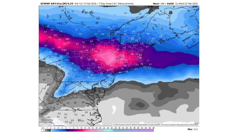
Particularly Dangerous Situation Tornado Watch Issued Until 11 PM CDT for Northeast Arkansas, Southern Illinois, Southern Indiana, Western Kentucky, Southeast Missouri and Western Tennessee
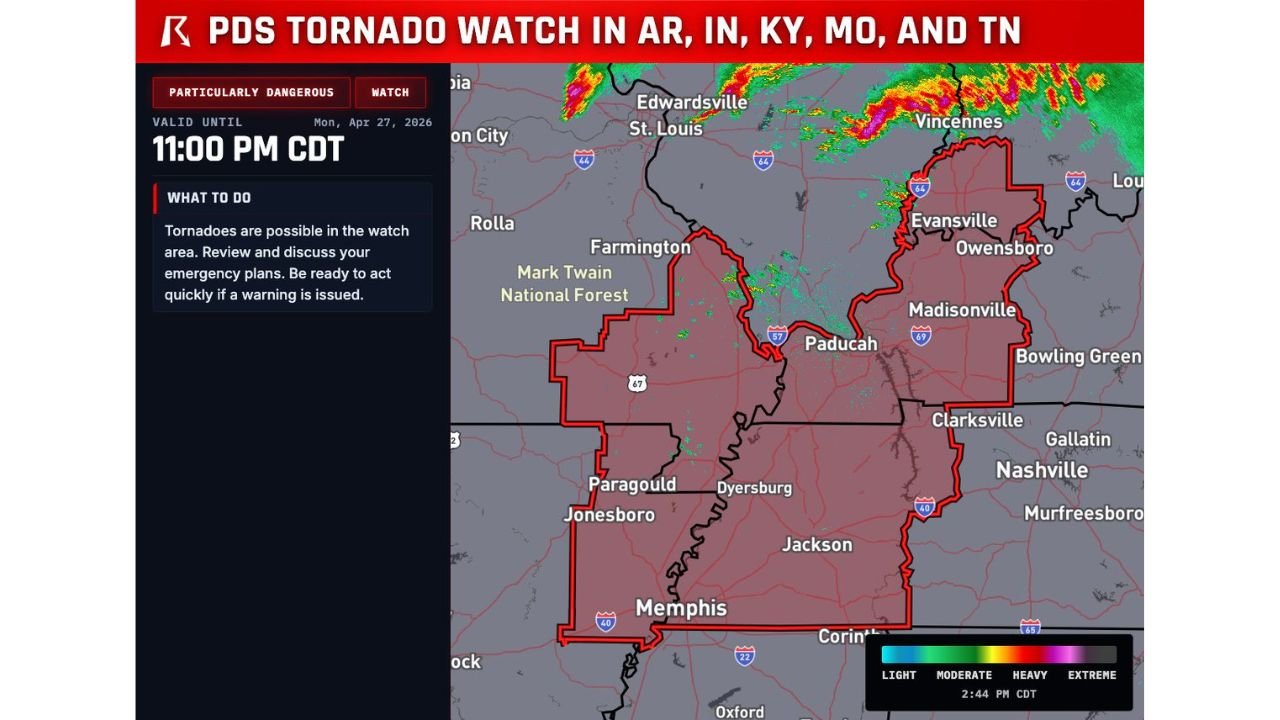
MEMPHIS, TN — This is not a routine tornado watch. A Particularly Dangerous Situation Tornado Watch — the highest-tier tornado watch the Storm Prediction Center can issue — has been declared valid until 11:00 PM CDT on Monday, April 27, 2026, covering a sprawling six-state corridor that includes northeast Arkansas, southern Illinois, southern Indiana, western Kentucky, southeast Missouri, and western Tennessee. Millions of residents across this region are now inside one of the most serious tornado watch designations in American meteorology.
A PDS Tornado Watch — where PDS stands for Particularly Dangerous Situation — is reserved for environments where forecasters have high confidence that multiple strong to violent tornadoes are possible, including tornadoes rated EF-2 or stronger, potentially reaching EF-4 or EF-5 intensity. These watches are issued rarely and only when the atmospheric data demands the highest level of public alert. Tonight, the data demanded it.
What This Watch Means and Who Is Inside It
The watch polygon covers an enormous geographic footprint across the mid-South and lower Midwest. Key communities confirmed inside the PDS Tornado Watch include Memphis, Jonesboro, Paragould, Dyersburg, Jackson, Paducah, Evansville, Owensboro, Madisonville, and Vincennes. The watch boundary extends northward through southern Illinois toward the St. Louis metro fringe and eastward into southern Indiana through the Evansville corridor.
The watch instructs all residents in the zone to review emergency plans immediately, identify their safe shelter location, and be ready to act the moment a tornado warning is issued. A watch means conditions are favorable for tornadoes to develop. A warning means one has been detected or is imminent. The time between a watch and a warning can be measured in minutes. Do not wait for the warning to move to shelter.
The Atmospheric Setup Behind a PDS Watch
A PDS Tornado Watch does not get issued without extraordinary atmospheric justification. Tonight’s environment across this corridor has been building all day and the data supporting this watch is exceptional across multiple parameters.
Surface dewpoints across the watch zone are running between 79 and 81 degrees Fahrenheit — an extraordinarily moist airmass that provides near-unlimited low-level fuel for supercell thunderstorms. The Significant Tornado Parameter — a composite index forecasters use to assess violent tornado potential — has been reading well above 1.0 across the watch area, with values identified earlier in the analysis period reaching as high as 1.8 in the most volatile portions of the environment. Values above 1.0 are associated with significant tornado environments. Values approaching and exceeding 2.0 are associated with violent tornado outbreaks.
Storm-relative helicity in the lowest kilometer of the atmosphere — the measurement of how much spin is available for tornado development at the surface — has been at extreme levels throughout the day across this corridor. That low-level rotational energy, combined with the extraordinary moisture and strong deep-layer wind shear, creates the trifecta of ingredients that produces violent, long-track tornadoes.
Watch Area City and State Breakdown
| State | Key Communities Inside PDS Watch |
|---|---|
| Arkansas | Jonesboro, Paragould, northeast AR counties |
| Illinois | Southern IL corridor, approaching St. Louis fringe |
| Indiana | Evansville, Vincennes, southern IN corridor |
| Kentucky | Paducah, Owensboro, Madisonville, western KY |
| Missouri | Southeast MO, Farmington area, Mark Twain National Forest fringe |
| Tennessee | Memphis, Dyersburg, Jackson, western TN |
What to Do Right Now If You Are Inside This Watch
Every person inside the PDS Tornado Watch boundary needs to act immediately. This is not a situation to monitor casually. The specific actions required right now are straightforward and critical.
Identify your shelter location before any warning is issued. The safest options are a basement or underground shelter. If no basement is available, go to an interior room on the lowest floor of the sturdiest building available — a bathroom, closet, or hallway away from all windows. Put as many walls between you and the outside as possible.
Make sure you have an active way to receive tornado warnings. A weather radio with battery backup is the gold standard. Smartphone emergency alerts must be enabled. Do not rely on outdoor sirens as your only warning — sirens are designed for people who are already outside, not for people who are indoors or asleep.
Mobile homes and vehicles offer no protection from a significant tornado. If you are in either, you must relocate to a sturdy structure before storms arrive.
Keep children, elderly family members, and pets close to the shelter location. Do not wait until a warning is issued to start moving.
Forecast Confidence
Confidence in significant tornado activity across the PDS Tornado Watch zone through 11:00 PM CDT is VERY HIGH. The Storm Prediction Center issues this designation only when the data is compelling and the threat is real. The atmospheric profile across this region — extreme moisture, very high instability, exceptional wind shear, and strong low-level helicity — is fully consistent with an environment that produces violent and long-track tornadoes. Confidence in EF-2 or stronger tornadoes occurring within the watch zone before the watch expires is HIGH.
This is a serious situation. Treat it as one.
More severe weather coverage is always on the horizon. Stay informed at ChicagoMusicGuide.com — your source for live tornado watch and warning coverage, PDS event tracking, and breaking severe weather alerts across the mid-South and the entire United States.