Tornado-Warned Supercells Strike Southern Missouri and Northern Arkansas as Storms Exit Dense Forests Toward the Mississippi Delta
POPLAR BLUFF, MO — A dangerous line of tornado-warned supercells is carving through the Ozark forest country of southern Missouri and northern Arkansas Monday evening, and what happens next has forecasters watching closely. As these intense rotating storms push out of the dense, friction-heavy forested terrain and into the flatter, open geography of the Mississippi Delta, the atmospheric conditions waiting on the other side could allow them to strengthen further — at exactly the moment warning lead times become most critical for populated communities downstream.
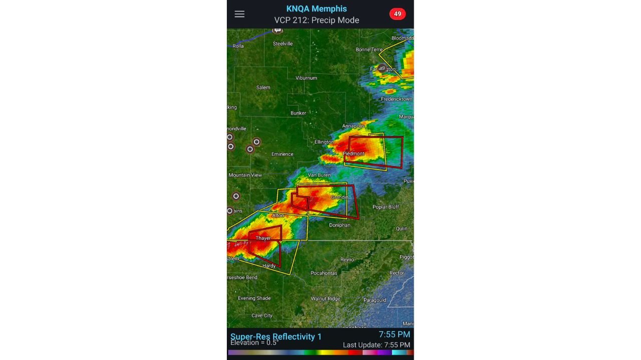
Live radar data from the Memphis radar site captured at 7:55 PM CDT shows the situation unfolding in real time.
What Radar Is Showing Right Now
Current radar out of Memphis operating in precipitation mode is displaying a northwest-to-southeast oriented line of intense supercell cores tracking across southern Missouri and into northern Arkansas. Multiple tornado warnings — shown as red polygons on current radar displays — and severe thunderstorm warnings — shown in yellow — are stacked along the storm line simultaneously, indicating a complex and rapidly evolving severe weather situation across this corridor.
The most intense radar cores, with reflectivity values shown in deep red and reaching into the 60+ dBZ range, are positioned near Piedmont, Grandin, Thayer, and Hardy. These are not isolated cells. The storm cores show a consistent structural signature — what current analysis describes as nearly identical mid-level cores with an increasing merger and intensification signature along the southwestern flank of each storm. When multiple supercells in a line begin showing the same internal structure, it signals a coherent, organized severe weather setup rather than a random collection of individual storms.
The area currently under the most active tornado warning boxes includes communities near Piedmont and Grandin in Missouri and extending southward toward Thayer and Hardy in northern Arkansas. Residents in these areas should be sheltered and underground if possible right now.
The Forest-to-Delta Transition — Why This Moment Matters
One of the most meteorologically significant aspects of this evening’s storm event is the terrain transition these supercells are about to make. The Ozark Plateau and the dense forested hill country of southern Missouri and northern Arkansas create what meteorologists call vegetation friction — the physical drag that trees, hills, and rough terrain impose on surface winds. This friction acts as a partial brake on storm-scale processes, particularly on the low-level inflow winds that feed supercell rotation.
As these storms push southeast out of the forests and into the flat, open Mississippi Delta lowlands — the agricultural floodplain stretching across eastern Arkansas and western Mississippi — that friction disappears almost entirely. Surface winds accelerate over open ground. Low-level inflow into storm bases intensifies. The boundary layer — the critical lowest layer of the atmosphere where tornadoes draw their rotation — becomes better connected and more energetically charged.
Current surface observation data shows dewpoints in the 79 to 81 degree Fahrenheit range across central and eastern Arkansas including Little Rock, Conway, Pine Bluff, Jonesboro, and Memphis. Dewpoints at this level represent an extraordinarily moist and unstable airmass. When storms exit the forest and tap directly into surface air this rich in moisture over open terrain, the conditions for tornado intensification are maximized.
Surface Moisture and Instability Data
| Location | Dewpoint (F) | Significance |
|---|---|---|
| Pine Bluff, AR | 81 | Extremely high — exceptional storm fuel |
| Little Rock, AR | 79-81 | Very high moisture in storm inflow layer |
| Memphis, TN | 80 | Delta moisture corridor fully loaded |
| Jonesboro, AR | 79-80 | Direct path of storm motion |
| Conway, AR | 79 | Central AR moisture well established |
| Hot Springs, AR | 79-80 | Western AR — high dewpoints statewide |
| El Dorado, AR | 79-80 | Southern AR fully saturated |
Dewpoints in the 79 to 81 degree range are among the highest values observed this far north this early in the season. This level of atmospheric moisture, when combined with the strong wind shear present in tonight’s environment, creates a fuel-rich environment for severe and tornadic thunderstorms.
Communities in the Storm Path
Piedmont and Wayne County, Missouri — Currently under active tornado warning. Intense radar core directly over this area at time of analysis. Immediate shelter required.
Grandin and Carter County, Missouri — Within active warning polygon. Storm cores tracking directly through this corridor.
Thayer and Oregon County, Missouri — Southern Missouri communities directly in the path of the advancing storm line. Tornado warning in effect.
Hardy and Sharp County, Arkansas — Northern Arkansas communities on the immediate southern end of the active warning zone. Storm motion carrying cells directly into this area.
Pocahontas and Randolph County, Arkansas — Positioned in the downstream path as storms exit forest terrain toward the Delta. High tornado risk as terrain transition occurs.
Jonesboro and northeast Arkansas — Sits directly in the path of storm motion as cells push into open Delta terrain. With dewpoints at 79 to 80 degrees and terrain friction dropping to near zero, tornado potential increases as storms approach this corridor.
Memphis, Tennessee and the Mid-South — Downstream recipient of storm activity as the line pushes southeast. Dewpoints at 80 degrees in Memphis confirm the unstable airmass is fully in place ahead of the storms.
Forecast Confidence
Confidence in continued significant severe weather including tornado-warned storms across southern Missouri, northern and eastern Arkansas, and the Mississippi Delta corridor through Monday evening is HIGH. The radar signature, surface moisture data, and terrain transition all support a scenario where storm intensity is maintained or increases as cells move into the open Delta. Confidence that the forest-to-Delta transition represents a critical intensification window is HIGH based on the atmospheric boundary layer characteristics currently observed. Tornado threat for northeast Arkansas and the Memphis area is MODERATE to HIGH for the evening hours.
If you are in northeast Arkansas, Jonesboro, or the Memphis metro area — do not wait to see what these storms do once they clear the trees. Be sheltered before they arrive.
More severe weather coverage is always on the horizon. Stay informed at ChicagoMusicGuide.com — your source for live storm tracking, tornado warning coverage, and breaking severe weather alerts across Missouri, Arkansas, Tennessee, and the entire United States.